
|
|
Area/Range |
|---|---|
|
|
56.66830°N / 4.95209°W |
|
|
Hiking, Mountaineering, Sport Climbing, Ice Climbing, Scrambling, Skiing |
|
|
Spring, Summer, Fall, Winter |
|
|
Overview
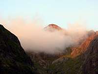
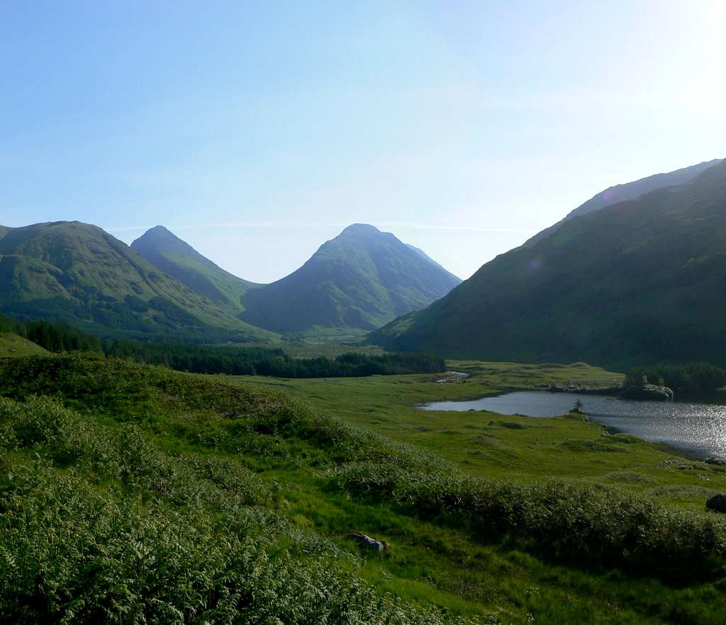
For anyone who has had the pleasure of driving through Glencoe, you will understand the difficulty in me truly describing its sheer beauty. For those of you who have had the pleasure of summiting its wonderful peaks you will know that it really is a wonderful and magical place.
Some of the finest hiking and climbing is available in this region the whole year round and I will cover the peaks (and their links) in more detail further down the page. These mountains are some of the most well known and frequented peaks in the Central Highlands of Scotland. The main peaks that are known in the area are Bidean nam Bian, Aonach Eagach and Buachaille Etive Mor; however Glencoe is home to plenty of beautiful mountains.
Geologically, Glencoe is part of the remains of the great range that stood almost 400 million years ago. The dramatic formation that we see today shows evidence of a huge volcano that erupted and then collapsed in on itself. Glaciations’ are also evident with the creation of the ‘U’ shaped valleys with their truncated spurs and hanging corries. The vast majority of the peaks in Glencoe are made up of Granite, Slate or Quartzite.
Historically, Glencoe is renowned for the unfortunate events of 1692 when the Campbell’s massacred the MacDonald’s. It wasn’t really the volume of people killed that made this so treacherous, it was the way that it was done that sent shock waves round the land. Having spent almost two weeks as guests of the McDonalds, Campbell of Glenlyon and his 128 soldiers turned on their hosts in the early hours of the morning on the 13th February, killing 38 as the rest fled to the supposed safety of the snowy peaks around. The following link details the entire story in three parts; Glencoe Massacre.
The following link has the song Glencoe Massacre by The Corries.
Getting There
Airports
For arriving in Scotland and making your way to Glencoe, the best airports to arrive in are;
Car
From Glasgow take the A82 road via Loch Lomond northbound direct to Glencoe.
From Inverness take the A82 southbound via Fort William direct to Glencoe.
From Edinburgh take the M9 to Stirling, then take the A84 Callander road, becoming the A85 until merging with the A82 northbound road at Crianlarich then on to Glencoe.
Rail, Bus or Ferry
Traveline Scotland - A one stop shop for all of the above

Red Tape
There is no red tape in Scotland due to the Land Reform (Scotland) Act 2003 which incorporated the Scottish Outdoor Access Code. This code, which commenced on the 9th of February 2005, has established statutory rights of access to land and inland water for outdoor recreation.
The Land Reform(Scotland) Act 2003
The following aspects should be taken into consideration when you are in the Scottish countryside;
- Seek local advice in regard to deer stalking or grouse shooting activities
- Ensure that all gates are closed behind you
- During the lambing season (March to May) ensure that all dogs are kept on a lead
- Please refrain from feeding or annoying any animals
- Limited parking space is available at the start of many routes, please ensure that you are not blocking a road and/or entrance
- Parking is provided at the start of some routes by the local farmers, it is polite to ask if you can use this facility
- Try to refrain from crossing fields with animals and/or crops if an alternative route is available
- Ensure that you treat the local environment with care by leaving it as you found it and by taking any litter home with you
- Any camp fires should be carefully watched and only used away from dense forest areas
The Peaks
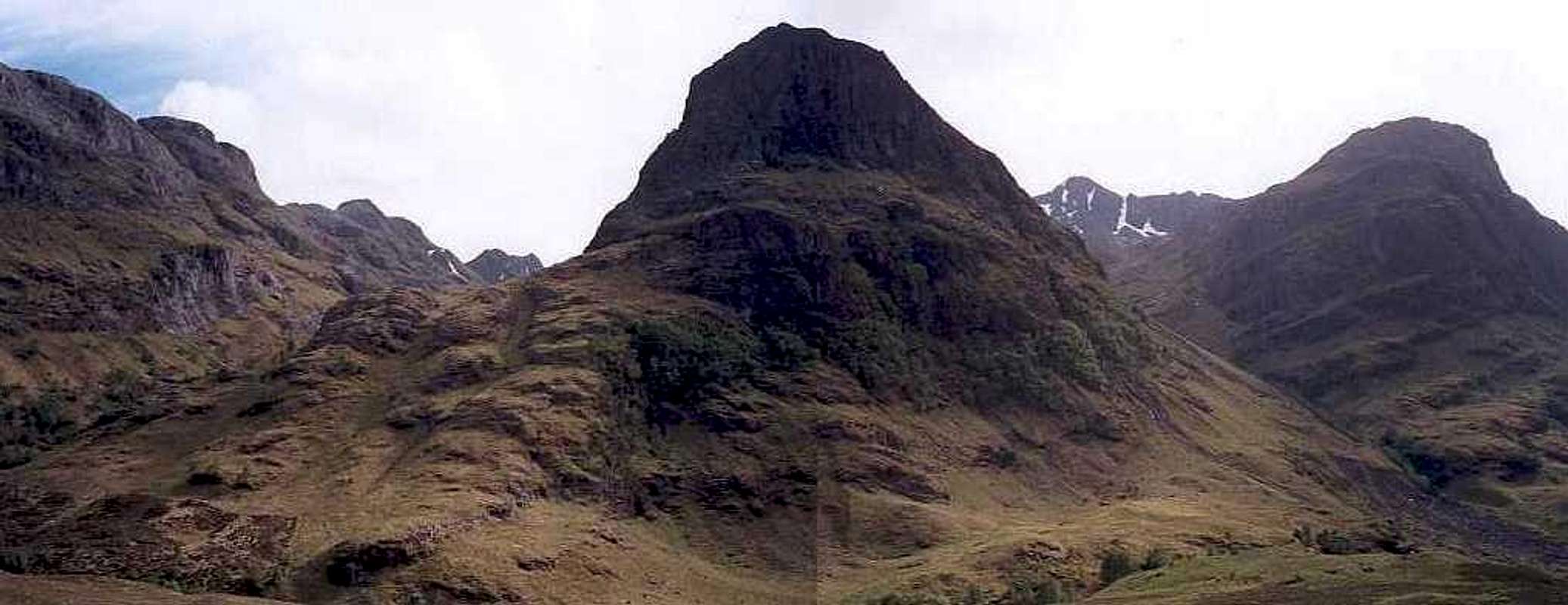
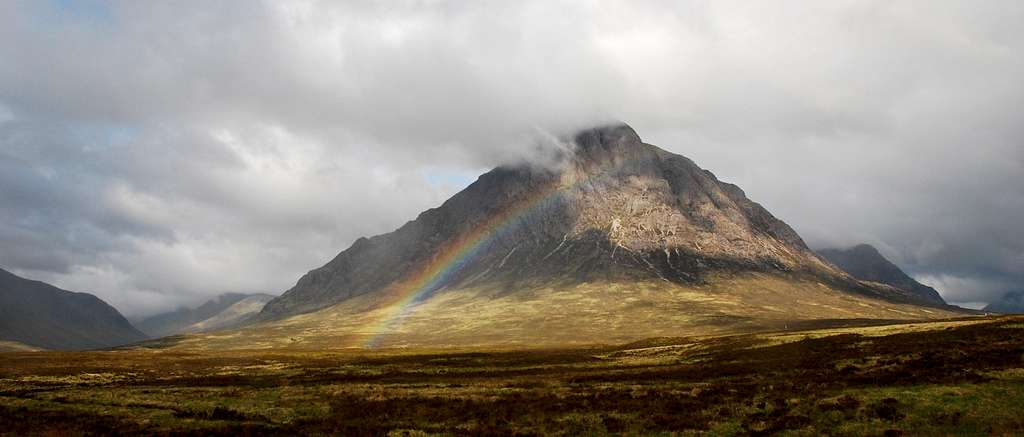
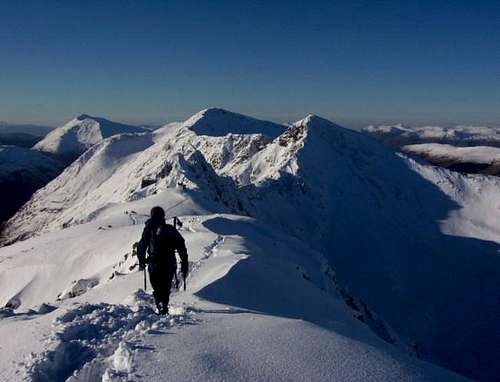
The Buachaille Etive Mor (Translated means; The Big Herdsman of Etive) (Pronounced; Booachil Etiv Moar) offers one of the finest views available from a main road (A82). In polls naming peoples favourite Scottish peaks the Buachaille Etive Mor is consistently found within the top five peaks. Undoubtedly the most photographed sections Stob Dearg, offers various rock climbing routes, these include Tower ridge, Crowberry ridge, and curved ridge. One of the earliest rock climbing peaks in Scotland with one of its initial ascents being made in 1895. The Buachaille Etive Mor is basically a long ridge made up of the following peaks plus one unnamed peak;
Stob Dearg(Translated means; Red Peak) (Pronounced; stop jerrack) 1022m/3350ft, Munro No. 110.
Stob na Doire(Translated means; Peak of the Copse) 1011m/3316ft, Munro Top.
Stob Coire Altrium(Translated means; Peak of the Corrie of Rearing) 941m/ 3087ft, Munro Top.
Stob na Broige(Translated means; Lively Peak) (Pronounced; stop na broo-ka) 956m/3136ft, Munro No. 207.
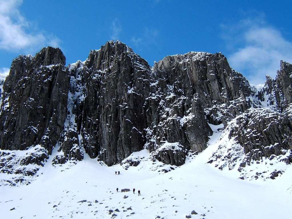
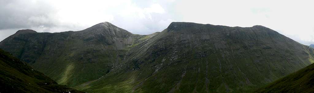
Bidean nam Bian (Translated means; Peak of the mountains) (Pronounced; Beetyan nam Beeoan) is most definitely the Queen of Argyll. Standing at a height of 1150m/3773ft (Munro No. 23) Bidean nam Bian is a complex multitude of ridges and peaks, which is hidden from view by the Three Sister of Glencoe when travelling along the A82 road. Bidean nam Bian offers numerous rock/ice climbing opportunities with the most notable routes being Church Door Buttress, Diamond, Pyramid and Broad Gully. The following make up the surrounding peaks and ridges of Bidean nam Bian;
Stob Coire nan Lochan(Translated means; Peak of the Corrie of the Lochans) 1115m/ 3657ft, Munro Top.
Stob Coire nam Beith(Translated means; Peak of the Corrie of Birches) 1107m/ 3631ft, Munro Top. Offers a fine 2km ridge walk which often carries a delicate snow arête in winter.
Stob Coire Sgreamhach(Translated means; Peak of the Fearful Corrie) (Pronounced; Stop korra skree-yach) 1072m/3517ft, Munro No. 65. This outlier and Beinn Fhada form the jagged outline at the head of the Lost Valley.
Beinn Fhada(Translated means; Long Hill) (Pronounced; Byn Faada) 931m/3123ft.
Gearr Aonach(Translated; Short Ridge) 692m/2267ft.
Aonach Dudh(Translated means; Dark Ridge) 892m/ 2924ft, This ridge contains ‘Ossian Cave’ the black cleft high on the north face that offers a wet scramble in order to get to, however it should be noted that there have been numerous accidents when parties have been descending.
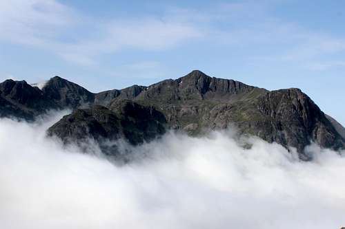
Glencoe’s infamous ridge is only truly appreciated when traversing its jagged pinnacles. In winter conditions the Aonach Eagach (Translated means; Notched Ridge) (Pronounced; Oenoch Egoch) is a grade III, although certain sections could be easily graded higher. Most people carry out the traverse from east to west, giving the easiest way of dealing with the awkward sections. The Aonach Eagach is made up of the following peaks;
Meall Dearg(Translated means; Red Hill) (Pronounced; Myowl Jerrack) 953m/3127ft, Munro No. 212.
Sgorr nam Fiannaidh(Translated means; Peak of the Fingalians) (Pronounced; Sgor nam Feeanee) 967m/3173ft, Munro No. 188.
Am Bodach(Translated means; The Old Man) 943m/3094ft, Munro Top.
Stob Coire Leith(Translated means; Peak of the Corrie of Slopes) 940m/ 3084ft, Munro Top.
The Buachaille Etive Beag (Translated means; The Little Herdsman of Etive) (Pronounced; Booachil Etiv Bek) is the smaller brother of the two herdsmen of Etive. The reasoning for the names is clear to see when both peaks are viewed from Glen Etive; however both offer excellent ridge walks with this peaks being smaller. Due to its location in Glencoe, next to the Aonach Eagach, Buachaille Etive Mor and Bidean nam Bian, the peak is generally overlooked, thus making it a quieter venue for a days walking. The Buachaille Etive Beag is made up of the following two peaks;
Stob Dubh(Translated means; Dark Peak) (Pronounced; Stop Doo) 958m/3143ft, Munro No.201.
Stob Coire Raineach(Translated means; Peak of the Bracken Corrie) (Pronounced; Stop Kora Ran-ach) 925m/3035ft, Munro No. 263.
Sgor na h-Ulaidh (Translated means; Peak of the Treasure) (Pronounced; Skor na Hoolya) is the lost mountain of Glencoe, hiding itself from view behind the giant of Argyll, Bidean nam Bian. Even when close to this peak on adjacent tops it is still difficult to ascertain the true shape of this peak with its complex ridges. Standing at a height of 994m/3261ft this peak is No. 149 in the list of Munro’s.
Beinn a’ Bheither
Beinn a’ Bheither (Translated means; Hill of the Thunderbolt) is basically made up of three peaks that form a north facing horseshoe. The peaks rise to the south of Loch Leven above the village of Balluchulish. The entire glen contained within is full of mature forest and a planned assault of these peaks should ensure you leave time to leave the forestation prior to the sun setting. These are the following three peaks that make up the Beinn a’ Bheither horseshoe;
Sgorr Dhearg(Translated means; Red Peak) 1024m/3360ft, Munro No. 107.
Sgorr Bhan(Translated means; White Peak) 947m/3107ft, Munro Top.
Sgorr Dhonuill(Translated means; Donald’s Peak) 1001m/3284ft, Munro No. 137.
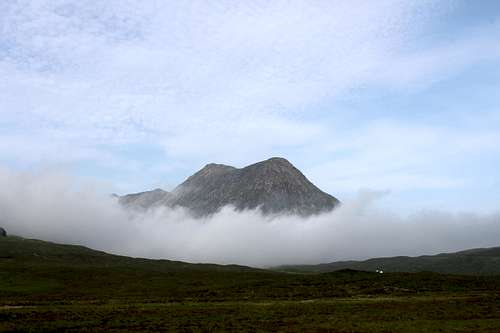
Sgorr na Ciche (Pap of Glencoe)
Sgorr na Ciche (Translated means; Peak of the Breast) is a fine peak that offers excellent views on a fairly easy morning/afternoons walk, as it stands at a modest height of 741m/2431ft. At a lower point (NN115586) a series of trenches can be found that are thought to have been made by Fingal’s horde as a means of defence against Norse invaders.
Garbh Bheinn
Garbh Bheinn (Translated means; Rough Hill) stands at 867m and is situated close to Kinlochleven, to the north of the Aonach Eagach. Again this is a fine hill that is largely neglected due to the stature of its near neighbours. Best ascended from the track on the south bank of Loch Leven, it is possible to ascend this and then traverse the Aonach Eagach via the connecting bealach.
Beinn a’Chrulaiste
Beinn a’Chrulaiste (Translated means; Rocky Hill) is located to the north of the Kingshouse hotel and stands at 857m. The peak appears as a great lump of a hill compared to it’s neighbours but offers some excellent views. Best ascended from the rear of the Kingshouse via the Allt a’Bhalaich and then by ascending its eastern ridge.
Beinn Maol Chaluim
Beinn Maol Chaluim (Translated means; Calum’s Bare Hill) is a fine peak with steep flanks to either side of it. Again, this is another peak that is hidden by the giants of Glencoe, but standing at a height of 907m still makes this peak of Corbett status. This peak can be ascended from either Glencoe or Glen Etive. In hard winters a gully on the eastern flanks offers a grade II climb.
Meall Lighiche
Meall Lighiche (Translated means; Doctor’s Hill) stands at 772m and is of Corbett status. This is truly retiring hill that is hemmed in on all sides. Located just to the north-west of Sgor na h-Ulaidh it requires a fair walk in and one that follows a narrow glen through rugged mountain scenery.
The Devils Staircase
The Devils Staircase peaks at roughly the 525m mark. Not really a peak, more of a killer for the poor souls trying to complete The West Highland Way. After 3 or 4 days walking suddenly to be presented with a steep climb seems rather harsh, but considering the location it could be a lot worse!
Accommodation


The best place to base yourself for climbing Sgorr na Ciche is in or around the Glencoe area. Below is a selection of available accommodation;
Hotels
Lodges & B&B's
Hostels & Campsites
Caolasnacon Caravan & Camping Park


Wild Camping
Wild camping is totally legal in Scotland and can be done in various locations in Glencoe. This is due to the Land Reform (Scotland) Act 2003 that was mentioned earlier. Here are some of the basic rules that should be adopted when wild camping;
- The larger the group, the harder it is to keep impacts to a minimum. Keep groups small.
- Camp as unobtrusively as possible.
- Remember that noise travels from tents disturbing wildlife as well as humans.
- Enjoy the freedom of wild camping without leaving a trace of your passage. Protect our country's outstanding scenery and wildlife as well as the wilderness experience.
- Camping on the same spot harms vegetation. Aim to move frequently and do not stay for any longer than 3 nights in the same place.
- Lighting fires poses a high fire risk on peaty soils and close to tinder dry grass. A high risk of fire can exist at any time of year, and not just in times of drought.
- Watercourses and loch sides are important sites for birds and animals. Take extra care when camping near burns and lochs, and try to avoid camping immediately beside them.
- Always find a spot at least 30 metres from fresh/running water when going to the toilet.
- Bury excrement in a small hole (not under boulders). A trowel or ice axe can be used to lift a flap of turf.
- Remove all litter (even other peoples!) Think ahead and only carry in what you are prepared to carry out.
Mountain/Weather conditions
The weather conditions in Glencoe can alter rapidly and you should ensure you are fully prepared for all weather eventualities. The following websites will provide invaluable information on the expected conditions for your planned trip;
Mountain Weather Information Service - West Highlands
Mountain Forecast - Pap of Glencoe
Met Office Mountain Forecast - Southwest Highlands
Scottish Avalanche Information Service - Glencoe
As stated, the peaks in the Glencoe region sit close to the west coast of Scotland. This can have a strong affect on the conditions on the mountains and it is a regular occurrence for Glencoe to experience its very own weather system and for it to totally differ to the weather in the nearby towns and villages. More detail can be found on the reasons for this occurrence on Proterra's article: Mountain meteorology of Scotland.
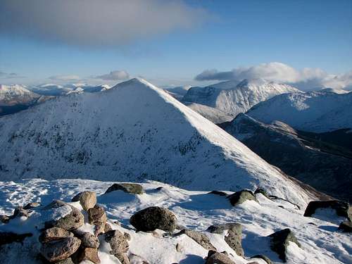
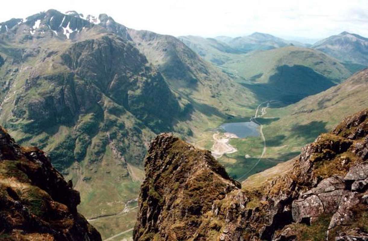
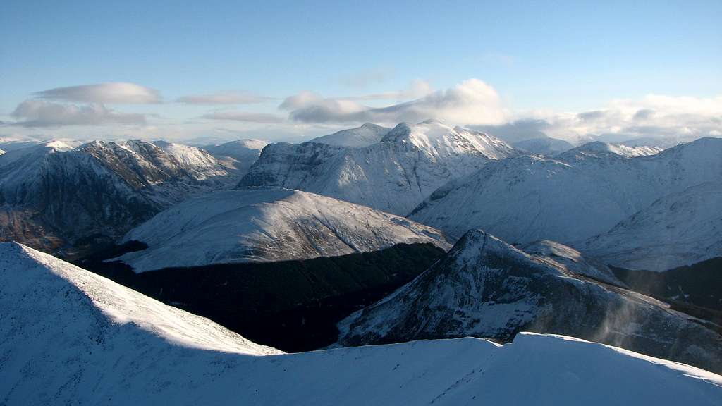
 Glencoe Panorama from Stob Coire nan Lochan
Bodies of Water
Within the Glencoe region there are numerous bodies of water. The main lochs/river is as follows:
•Blackwater Reservoir: This used to be a scatter of Lochans prior to the construction of the dam through 1905/1906.
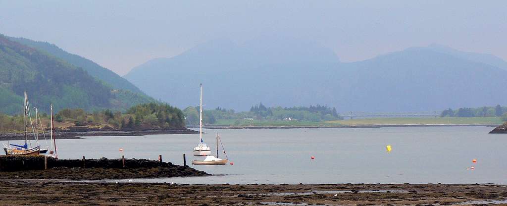
•Loch Leven: There is a crossing of this loch at the Corran Ferry, which leads to Ardnamurchan. One of the major lochs in Scotland, this offers ideal opportunities for fishing.
•Loch Achtriochtan:
•River Etive:
•River Coe:
•Lochan na Fola:
•River Coupall:
•River Leven:
Some of the minor bodies of water within the Glencoe region include:
•Dubh Lochan
•Lochan na Feithe
•Wabicks Loch
•Lochan nam Breac Reamhar
Scottish Allts (Mountain Streams) and Rivers
Scottish Lochs/Lochans
Gaelic Names Basic Glossary
Gaelic is a very rich language topographically, and this basic guide to some of the elements of place names should hopefully assist in understanding how/why the mountains on this page (and Scotland as a whole) are derived. It should be noted that in Gaelic a describing word would be placed at the end of a mountain name; i.e. Sgorr (peak) Dhearg (red), Sgorr Dhearg translated is Red Peak. This would read in English as Peak Red. For a full detail of Gaelic mountain pronunciations I recommend the following book;
•Scottish Hill and Mountain Names; by Peter Drummond.
Glossary
Allt = Mountain stream
Aonach = Ridge, moor
Ard, Aird = High place
Ba = Cattle
Ban = White, pale
Beag = Little
Bealach = Pass
Beinn(Ben) = Mountain
Beith = Birch
Buidhe = Yellow
Binnean = High, conical hill
Both = Hut
Cas = Steep
Caorach = Sheep
Carn = Heap of stones
Ceann = Head, headland
Clach = Stone
Coille = Wood, forest
Creag = Crag, rock, cliff
Cuil = Nook, recess
Damh = Stag
Dearg = Red
Dubh = Black
Eilean = Island
Eun = Bird
Fada = Long
Fionn = White, holy
Fraoch = Heather
Fuar = Cold
Fuaran = Well, spring
Gabhar = Goat
Garbh = Rough
Gearr = Short
Glas = Grey, green
Gorm = Green, blue
Guala = Shoulder of hill
Iolair = Eagle
Labhar = Loud
Lairig = Pass
Leacach = Stony slope
Leathad = Slope, brae
Liadh = Grey
Maol = Bare top
Meall = Round hill
Mheadhoin = Middle
Mor = Large
Mullach = Top, summit
Odhar = Dun coloured
Ruadh = Red, brown
Sgorr, Sgurr = Rocky peak
Sneachd = Snow
Sron = Nose, spur
Stob = Point or Peak
Uisge = Water, river
Books & Maps
Books
Central Highlands by Peter Hodgkiss
The Munros by Donald Bennet & Rab Anderson
The Corbetts and Other Scottish Hills by Rob Milne & Hamish Brown
The Grahams and The Donalds by Rab Anderson & Tom Prentice
Glencoe Climbers Guide by Rab Anderson, Ken Crocket & David Cuthbertson
Highland Scrambles South by Iain Thow
Ski Mountaineering in Scotland by Donald Bennet & Bill Wallace
Hostile Habitats by Mark Wrightham & Nick Kempe
Scottish Hill Names by Peter Drummond
Ben Nevis & Glencoe by Ronald Turnbull
Maps
OS Explorer 384 - Glencoe and Glen Etive
OS Landranger 41 - Ben Nevis: Fort William & Glencoe
Harvey Superwalker Map - Glencoe
External Links
Mountain Rescue Committee of Scotland
Heading For The Scottish Hills
The Scottish Mountaineering Club
National Trust Scotland - Glencoe
Glencoe Massacre
The West Highland Way
Boydie - May 14, 2019 11:53 am - Hasn't voted
Re: The very first letterCheers for pointing that out Yatsek. I've now input the letter G