
|
|
Area/Range |
|---|---|
|
|
56.83695°N / 4.15283°W |
|
|
Hiking, Mountaineering, Trad Climbing, Sport Climbing, Toprope, Bouldering, Ice Climbing, Aid Climbing, Big Wall, Mixed, Scrambling, Skiing |
|
|
Spring, Summer, Fall, Winter |
|
|
4416 ft / 1346 m |
|
|
Introduction

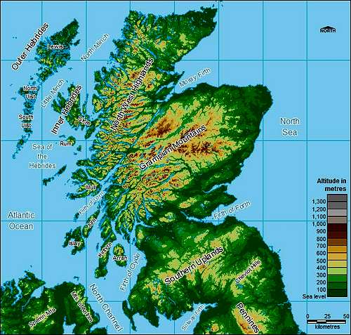
Map of Scotland
There are many reasons to introduce Scotland as an "Area/Range" here on SP.
Some may underline, with good reasons, that Scotland is a political country, and that administrative borders do not delimitate a range. Furthermore, Scotland itself is divided in at least 3 completely distinct geologic ranges, and from the pure geological point of view, it would seem more appropriate to encapsulate also in such a unit the Pennines, then the Lake District, and so on, and perhaps all ranges in Great Britain....
However, for many foreign people interested in mountains, Scotland is a mountainous area, and very few foreigners know exactly what are for example the Grampians. Apart from that, we can also underline the very strong culture and regionalism of Scotland, in which mountains have their part (folkloric songs, places where whiskies are distilled, etc).
Finally, this page aims to summarize facts, information, and main specificities about Scottish mountains, whose place is in a main page, leaving all more specific details for existing and forthcoming sub-range pages.
All suggestions are welcome in order to improve and enrich this page. All owners of objects (routes, ranges, tops) located in Scotland are welcome to attach them to this page, except if a sub-range is already existing for them.
For the moment, and as long as many main areas of Scotland are not created yet in SP, attachment structure of Scotland doesn't have to be very strict, but as soon as the regions coverage will be more complete, I invite everyone to follow as close as possible the taxonomy of Scotland described in this forum thread.
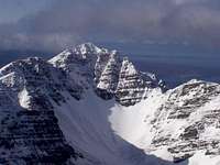
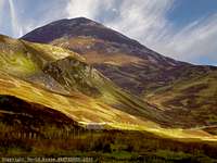
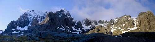
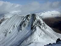
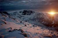
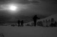
 The Cairngorms in winter
All pictures of Scotland are welcome to be added to this page.
Overview
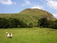
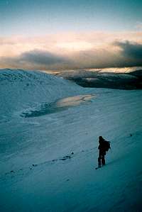
For some of you who hiked in the Great Britain or northern countries, this feedback may sound a bit odd, but there are many unaware foreigners who hike completely unprepared in Scotland for the first time.
It will never be repeated enough: the Scottish "hills" are small (the average height of the high ones is 1000m), but they can turn quickly into BIG mountains, real mountains, and should NEVER be underestimated.
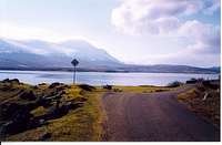
First of all, besides mountains, Scotland is a country of sea. Many “lochs”, linked or not to the sea, are near the altitude zero. In Scotland, there are also no roads climbing very high, no high passes, no lacets. Roads are also always staying near the zero level, often circumventing the shores. This means that for a mountain of 1200m, there is often 1200m to climb.
Scottish mountains are also northern mountains. Out of the meteorology scope, it’s about the the nature of the ground. There are very few maintained paths of rocky consistence, and to climb a top off the beaten tracks, you will often need to make your way in the middle of nowhere, in the grass, in the moss, in the bogs...
Scottish pastures are not the same at all than most of mountain meadows as we know them in mountains of continental Europe. In most places, this is peat, mud, water. The highest you go, the most, and especially in grassy hollows. You can put your whole leg in it. Some people who are very fit to hike on dry and rocky mountains can suddenly experience big difficulties and extreme tiredness walking hours on such ground.... On the other hand, those with knees problems might find it fantastic kind of terrain to walk on !
Weather
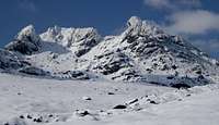
Scottish mountain weather, despite some specificities, is a real mountain climate, as one can experience for example in the Alps, and winter in Scottish mountains is a real mountain winter.
One common joke says British keep measuring in feet, as the same altitude corresponds to the same conditions and environment in other “continental” European ranges, in meters... But is joke is more true than ironic !
Out of the high season, when you climb a peak of more than 1000m. Everything is ice, rock, and wind. The same as we find over 2500m in Alps or Pyrenees.
The main difference with continental mountain climate is that weather can be good and bad several times during a walk.
Scottish people used to say that you can “experience the four seasons in the same day”. But, very often, Scottish rain is not a heavy mountain rain as we know. This is just a misty rain.
Huge mountain thunderstorms, as we know in Alps or Pyrenees, never occur in Scotland (or extremely rarely), and there is no obvious logic about what time to make the walk during a day. In continental mountains, we use to say the earliest the best, but in Scotland, during such days, the best moment often tends to be in the middle of the day, or any other moment.
This doesn’t mean that you should systematically cancel your trip. Long approaches, when the trail is obvious, can be done in misty rain and/or darkness. But, of course, if you are really sure that there is a chance to expect an improvement during the day. Hesitating weather often provides spectacular lighting effects and amazing colors on the mountainsides. This is all what makes the charm of hiking in Scotland.
In few words, Scottish hiking is a water sport, and waterproof gear is essential!
Orientation
Tricky weather and featureless grassy landscape means also ORIENTATION.
If you think you are infallible in orienteering just because you always find the right way on the maintained trails of the Alps or Pyrenees, or just by watching landscape features, you should completely review your opinion of yourself, and make sure you can really use a compass and a map. And not just by watching where the north or that top is, but to really use a map, which means keep steadily an azimuth, and have a precise idea of the distance you walked during a lap of time, and precisely locate yourself on the map. If you are an addict of the GPS, forget the idea of only relying on it, and learn to use maps.
Scottish landscape is made of endless grassy bumps all similar to each other, and mountains out of the beaten track (and they are many), have simply no trail. If weather changes, you quickly find yourself trapped in the middle of nowhere, and without such knowledge, you can easily hike down a mountain the wrong side, and find yourself lost in an area where there is absolutely nothing, and no one to rescue you. The whole Scotland is made of such places. Worse, if this happens in winter at dawn, you are done. Getting lost in Scotland can be really dangerous !
Equipment

Of course, mountaineering in Scotland will require a similar mountain gear than in many other mountains, but, according to all what was mentioned above, a special attention must be paid for few items :
- Good waterproof boots. If you don’t like walking with the feeling to wear cold wet sponges instead of shoes, make sure you have high boots which do not let water get in between the laces. Keep the impermeability by maintaining them regularly with waterproof spray.
- Gaiters. Because you can dig your leg in the mud much higher than the ankle !
- Out of the high season during uncertain weather, waterproof trousers are not a luxe too.
- Ban the jeans as hiking trousers, they are very unpractical when wet, choose rather trousers made of a flexible (and not too spongy) material. Lycra is ideal.
- Polar, waterproof jacket with good hood (Scotland can be also horribly windy) ; during cold days a warm hat covering ears. Gloves.
- Plastic map folder in order to keep it dry. A wet map will get torn by the wind in a second...
- A compass, a mobile phone (in all Scottish mountains you have the network).
- If you have an expensive camera or other items that need to be kept dry in the rucksack, have some plastic bags for the worse situations.
- Dry clothes (socks especially) in the boot of the car for when you finish ! And few pounds for the pint near the fire in some inn on the way back :)
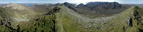
Geography and landscapes
The aim is not to make a list of the areas like a geography book, neither to make a complete lesson of Scottish Geology, but to give a general idea of the general shape of mountainous areas in Scotland.
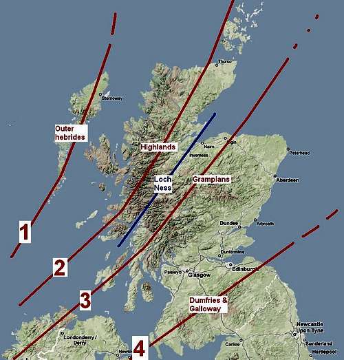
Scotland, with the mountains of Wales and Ireland, is located on a geologic fault whose continuity is the Alps of Scandinavia. This fault runs from South-West to North-Eat, and in Scotland, we can say that approximately four parallels stripes that follow this direction, with depressions in between.
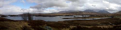
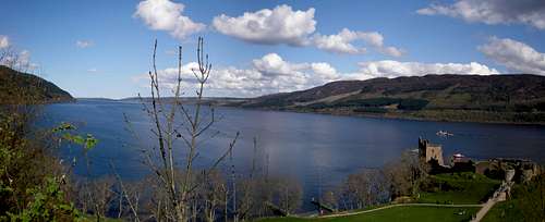
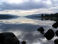
In the very middle lies the Loch Ness, perfectly straight and oriented in diagonal. No other geographic feature illustrate so well the direction of the Scottish fault.
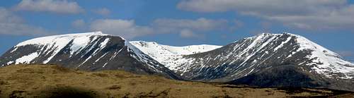
 Scotland in few lines Scotland in few lines |
 Map of Scotland Map of Scotland |
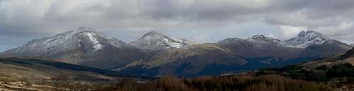
The Grampians make the most important mountainous range lying just under it, and fading out near the axis Glasgow-Edinburgh. This area owns the highest tops of Scotland. They are described in a very detailed page a href="https://www.summitpost.org/custom-object/459145/grampian-mountains.html">here.
On the opposite side of the Loch Ness lie what Scottish call “the North-West Highlands”.
Often, for the foreigner, partly due to whiskies advertisements and so on, the word “highlands” is a bit usurped and we tend to use it for the whole wild areas of Scotland. But geographically speaking, the “highlands” mean all areas north from the Grampians, including them. Then, for this very area, the best term is “North-West Highlands”.
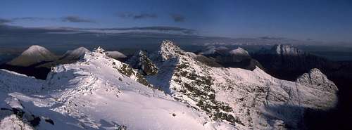
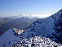
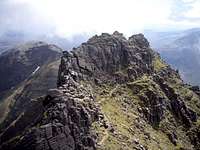
They also have their fair amount of high mountains, despite less numerous than the Grampians, and more concentrated on the West. But this is compensated by the fact that few of them (and this without the unclassifiable Isle of Skye) have particularly sharp shapes and original features, for example in the region of Torridon.

South from the Grampians is located a wide depression in which are located the two biggest cities, Glasgow and Edinburgh, 40km far from each other, respectively on the Firth of Clyde and the Firth of Forth . Looking at the shape of Scotland, under this depression, Scotland becomes wider again, before narrowing again at the English border. This region constitutes the 3rd mountainous part, which we commonly call Dumfries and Galloways, sometimes including also the Borders . None of these hills are “Munros”, but they offer peaceful walks out of the crowds.
As for the “fourth stripe”, the northernmost one, geologically speaking, it is separated by the sea from the rest of Scotland and is represented by the group of hilly islands of the Outer Hebrides, also running parallel to the SW-NE axis. The little island of St Kilda, far away from the Hebrides, is the only part of Scotland not to belong to these four groups running parallel to each other....
Still speaking landscapes, Let’s comment now a bit about the East-West contrast. For all these ranges, we can state approximately the same tendency.
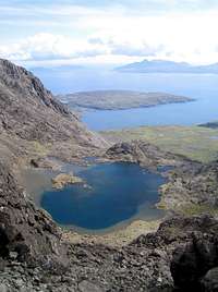
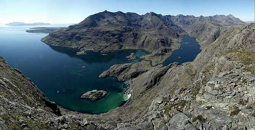
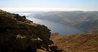
On the westernmost regions are located the steepest mountains. Very often, these mountains are surrounded by long lochs, more or less linked to the sea, making the access to few of them quite long, and some very long walking approaches in few cases. There are even a fair number of famous Scottish mountains located on islands, the “Inner Hebrides”. Some of these mountainous islands are : Mull, Jura, Arran, Skye, Eigg, Rum...
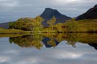
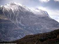
In the West, all valleys have a perfect “U shape”. This geography is the heritage of the ice age which, due to the proximity of the Gulf Stream (and then more wet weather), dug deeper glaciers as we go west. The same logic applies to the west coast of Norway, Chili, or the North-American continent. Due to this proximity of the sea and exposure to the elements, the vegetation is also more scarce in the westernmost mountains. The first of them start rising straight from the sea without a single forest, just grass, while mountains of the same size and shape, further in central Scotland, have at least 200-300m of forest on their base.
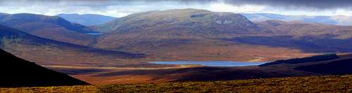
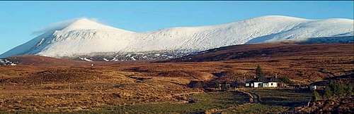
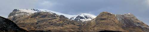
Going further East, the morphology continues to change. Mountains tend to be less and less sharp and steep. In the Cairngorms, the most famous mountainous region located in Eastern Scotland, landscape and morphology are completely different. Mountains look rather like big granitic plateaux in which the ice erosion worked in more dispersed places, leaving softer shapes. But still very strongly, leaving in few places more varied and original shapes of erosion. Lairig Ghru, Scotland’s biggest canyon, is one of them.
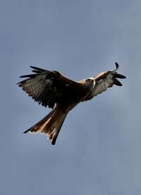
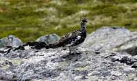
The mountains in these regions are also covered with much more vegetation, generous forests, including some of the rare specimens of the original Scot Pine; meadows covered of heather. Fauna is also more present, with countless deer’s, hares, ptarmigans.
Weather is also completely different than on the West Coast. By the mean of the “barrier effect” of the many tops located more west, and many combined Foehn winds, the eastern mountainous areas of Scotland experience a sort of micro-climat, less oceanic, which sometimes give the impression of a mini “continental weather” in the heart of Scotland herself. During winter for example, it usually receives much more snow.
All these aspects are very well detailed and explained in the excellent article about Scottish meteorology by Proterra.
The Munros

If you hike in Scotland for the first time, while reading about mountains or talking to other people, soon or late you will hear this word. First, if you don’t ask what is it, you will think about some famous mountain range somewhere in Scotland! But the “Munros” are everywhere...
The Munros are the summits in Scotland over 3000 feet, or 914m. Why this 3000ft limit? Because this is a round number which most high Scottish mountains tend to reach, and which usually makes the limit to the high mountain environment (rock, ridges, ice, snow…). The same way Alps have their four-thousanders, Himalaya the 8000’s, etc, etc.
There are 284 Munros in Scotland. Every walker collect them as stamps, some of them manage to do all of them in a life. they were first documented by Sir Hugh Munro, an original member of the SMC (Scottish Mountaineering Club), in 1891. He did not climb his own creations and died in 1919 when working on a revison of his infamous 'tables'. The name 'Munro' has become synonymous was Scottish mountains over 3000ft (915m).
It is only recently that all tops were correctly measured, thanks to recent laser technologies. During many decades before, their number kept changing (often increasing, but not always…). Unpopular areas occasionally became suddenly highly frequented, and the opposite also occurred as “unlucky mountains” happened to lose the “Munro status” for a story of few metres…

Besides this “trainspotting” aspect of Munro-bagging, as long as you are not too obsessed by the exactitude of the term, it is an excellent sporting activity. Many hikers go to ranges that own several “Munros”, and bag several in a row. In some cases, this is a real physical challenge, and most of such trips are very rewarding. Looking for unpopular Munros will also take you to secret places in Scotland.
The Munros are not the only list of tops in Scotland. You have also the Corbetts, from 2500 to 3000. These were first documented by John Logie Corbett in the early 20th century to provide a basis for cataloguing lower Scottish mountains and one a munroist himself, Their merit includes promotion of many interesting tops which fail to reach the Munro status (ex: the Cobbler, Quinag, etc), and many very interesting, sometimes wide, mountainous areas, in which no Munros are located (ex: Dumfries and Galloway, some islands like Arran, etc).
Besides these two lists, some other lists exist; more or less known as the altitude goes lower and lower :
- The Donalds : hills in Central & Southern Scotland chosen by Percy Donald with a drop of at least 100ft of primary factor.
- The Grahams : hills between 2000 and 2499 ft with primary factor of 500ft chosen by Fiona Graham
Some people also refer to “British Munros”, including the rest of the British mountains that reach 3000ft, in Welsh Snowdonia, Irish Kerry, or England's Lake District, all of them just around a dozen all together. Not a very significant amount compared to the “mass” of Scotland, but not less attractive mountains !
Rock-climbing in Scotland
The mountain activities in Scotland are not only limited to hiking. Despite Scotland is mostly made of mountains with gentle shapes, there is a fair number of world-renowned spots.
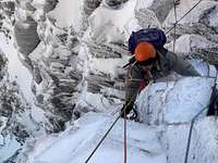
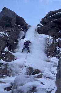
Ben Nevis, Scotland's highest mountain, owns one of the tallest vertical drops one can find in UK, and many gorgeous routes are located on the North East Face. Ben Nevis is also in winter an ice climbing heaven.
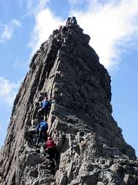
On the Island of Skye are located the most atypical mountains of UK, the Cuillins. Of volcanic origin, made of a very tought and abrasive kind of granite called "Gabbro", they are extremely sharp and jagged. Thousands of rockclimbing routes are located on the dozen of main peaks. This is the prefect area to practice "real mountaineering", involving both rockclimbing and mountaineering skills.
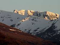
The Cairngorms, in Eastern Scotland, as mentioned above, were subject to particllarly strong ice erosion concentrated in some places, which created some of the most important cliffs in Scotland. Cairngorms are mostly made of a granite of very good consistency which make a fine rock to climb.
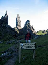
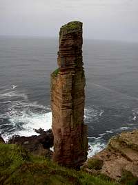
Finally, some of the finest rockclimbing spots are also located on coastal crags, for example on the Old Man of Hoy, and more in general everywhere where cliffs are made of a thought rock and provide a significant vertical drop.
A good website which contains a lot of information about rockclimbing in Scotland (and UK) is : www.UKClimbing.com
Books
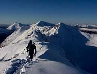
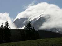
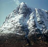
Carn Mor Dearg Arete

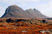
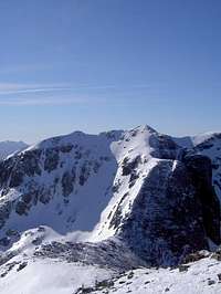
Baosbheinn
The two reference books for the Munros and the Corbetts are undoubtly the two edited by the Scottish Mountaineering Club, and titled identically (“The Munros”, and “The Corbetts”). These books, especially the first, are the bible of the Scottish hiker, and you will spend many evenings dreaming between the chapters and the pictures.
The Cicerone guides also have a wide choice of books about Scotland: catalogue.
The Scottish author and mountaineer Cameron McNeish also has a fine selection of books and dvd's on the Scottish peaks.
..............
more books welcome in this section !
When to hike
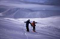
Scottish mountainners can go during the four seasons, each has advantages and inconvenients.
* Summer is the warmest season, and perhaps the only one during when you can afford going out not with too many clothes. You will meet more people on popular trails. The Scottish landscapes are also not the most beautiful during this period, as all tend to be uniformly green. On the other hand, when perfect weather is settling for a whole day, you can enjoy the daylight during a lot of hours, from the very early morning, to the sunset around 10pm.
* Autumn can provide splendid days with the most stable weather during the whole year, but also some horrible rainy periods. During this time, the whole landscape get warm colours turning yellow-orange-reddish. The grass on the slopes of the montains get an infinity of different tones, depending on the exposure to the sun and the height. After cold periods, it is also not rare to see all scottish tops topped with a white cap, starting exactly at the same height on every hill, with a precision of only few meters. This kind of landscape which can rarely be observed out of Scotland (or British mountains), has something magical and cannot leave indifferent the eye of the visitor.
* Winter can be really harsh, with very low temperatures baning any trip to mountains, especially during January-February. But not systematically. There will always be some periods warmer than others, during which you will experience great snow conditions on the tops, while the lower parts are still uncovered. One should also be aware that during this period, days are very short, and for a long hike, starting early is always much safer. Winter trips are on the other hand very rewarding for the photographers, as the sun tend to stay close to the horizon, providing colorful luminosities all day long, especially when clouds play with the rays of light.
* The Spring start when snow is melting, first on the pastures, and, much later, in the corries where it remains out reach from the sun. When the pastures reappear after the melting of the snow, landscapes are not very attractive: dead grass is between dark green and brown. Mountains experience some of the most capricious moments of the year with more sudden and unpredictable rainfalls than ever. After the passage of cold fronts, it is not rare to experience some late conditions of good fresh snow (which, however, do not last long). From the month of May, grass and trees recover their green vivid tones, with a wide range of tones: again, one of the finest moments of the year. But, partly wasted by the presence of a famous insect...
The midges
The midges are some very small insects who live in Scotland, as well as some wet parts of Scandinavia.
More exactly, in Scotland, the midges are a familly of the Nematoceran Diptera, the "mountain midges", called Deuterophlebiidae.
The midges, whose larval stage is aquatic, appear at the end of the spring, as soon as the temperature grows, and the mountain bogs packed with water. This period of the year corresponds usually to the end of the spring and the summer.
Their presence is not very identifiable during windy days, but without wind, they suddenly become a terrible scourge for the mountaineers, especially when in short clothes (T-shirt, etc)
Almost completely invisible to the bare eye, you notice their mischief long after they have started... your skin is covered with very small red spots, and becomes very itchy; painful, even, in some extreme cases. Several hours later, they fade out and the feeling completely disappear.
Some people are in fact more sensitive to this pain than others. Also, it seems that the midges tend to prefer some kind of skins more than others !
Few methods exist to get rid of them. Some flagrance sprays, which act like repellents are sold in some shops in Scotland. When walking, if you are surrounded by them, never stop for too long in one place, keep walking: the most windy, the less damage... Always wear some light clothes with long sleeves and legs, even if the weather is hot.
If you camp, beware of always zip the mosquito-net as soon as you enter or leave. Some people whose skin is highly sensitive even hike sometimes with special hats with mosquito net around the face, like in Africa !
Mountain access and erosion
In most of the Scottish mountains, hiking is allowed in total freedom.
But, in some exceptional cases, some routes are not possible, just because the land belongs to someone.
Most of the time, such areas are fenced fields. Always avoid climbing fences, or penetrating deliberately in what seems to be someone's property. Sometimes, this is not very obvious, but always behave respectfully, and politely if you are caught in such situation.
If you are forced to cross a fenced area with cattle (which can happen for example if you walk down a mountain in a way you didn't expect very much), always mind to close the gate behind you, this is one of the most important things.
For more information, read this website :
http://www.outdooraccess-scotland.com
Another important issue is the mountain erosion due to hikers.
Most of the Scottish mountains, and especially the northernmost ones are made of a rocky base, on which lie a certain thickness of various nature: sand, peat, mud; which is covered by a vegetal layer like moss, grass.
Scottish mountains are extremely exposed to the oceanic climate and experience very often heavy rains. The vegetal layer prevents these heavy rains to sweep away the slopes of the mountains, even in the most fragile places. On some popular mountains, the frequency of passage of hikers is such that the vegetal layer is distroyed. Fortunately, in most cases, this "erosion" makes just a bare line without grass, in which everyone tend to follow. But, as soon as the traffic is excessive, the trail gets deeper and deeper. You can find yourself sometimes walking in a trench so deep that your hands and elbows are touching the grass on the right and on the left.
When a trail becomes too uncomfortable to walk, people tend then to walk aside, finding the bumps and irregulatities of the terrain finally more comfortable than walking in a trench. A second trail appears, with a second trench...Then, the trail gets wider and wider.... And hikers are not the only scourge, now the rain participates, and carries away important masses of mud and soil.
On some mountains like Schiehallion, or Stac Pollaidh, the wound is several meterw wide, and visible from several kilometers far, detroying for ever the original aspect of the mountain. In order to prevent such damage, always try to keep on the main trail, walk aside as less as possible. If you do so, walk as far as possible from the original trail, in order to "increase the dispersal" of the erosion. Never take shortcuts between laces, never destroy the trail more in places where it is already damaged.
Always walk softly, and not "crush the mountain" under every step. Mountains are like a gentle girl... the softest you behave, the most rewarding they will be.
Accomodations & campsites

The aim of this section is not to provide all accomodations in Scotland (they are more detailled in subregions pages), but to give few tricks about how to find hiking-convenient accomodations in Scotland.
* Campsites are usually working from around end of May to end of September/October. But few of them in popular places work (officially...) all year long.
Here is a good website to find campsites in Scotland, in the area you plan to go:
http://www.scottishcampingguide.com/
* Accomodating into houses of course is more expensive, but a good number of basic and simple accomodations exist in the whole Scotland, they are just a bit more difficult to find, because often less referenced on the internet.
You can try these websites to find few of them:
http://www.embracescotland.co.uk/
http://www.groupaccommodation.com/
Otherwise, you can always try to type a place name followed by "self-catering" in Google. But results often provide contrasted results;
the interesting ones often drowned in a mass of B&B with higher (often unnecessary for the hiker) standard...
* Another very interesting option, which for the foreigher may sound a bit ridiculous at first time, are the Youth Hostels. In many countries, Youth Hostels are dirty cheap accomodations for students in touristic towns. But in Scotland, even if there are a bit of those in the large cities, most of the Youth Hostels located in the countryside are much closer to the concept of "hiking accomodation", not to say the equivalent of mountain refuges for few remote ones accessible only on foot like Glen Affric.
Here is the website of the Scottish Youth Hostels Association :
http://www.syha.org.uk/
Best pubs after a hike...
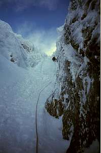
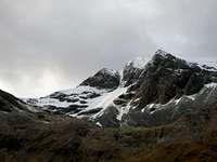
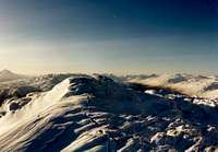
Point 5 Gully, Ben Nevis
Aladdin's Mirror, Cairn Gorm
Drinking a pint in dry clothes, sitting next to a warm fire, in an old inn or pub on the road, between fiends, discussing the events of the day...
This is also one of the charms of the outdoors in Scotland. The aim of this section is to list few of them.
* The Drover Inn, in Inverarnan
* The Clachaig Inn, in Glencoe
* The Kings House Hotel, in Glencoe
* The Bridge of Orchy Hotel, in Bridge of Orchy
* The Falls Of Dochart Inn, in Killin
* The Rowardennan Hotel, in Rowardennan
* The The Torridon Hotel, in Torridon
* The Ledgowan Lodge, in Achnasheen
More pubs will be welcome in this section ! :)
How to get there

Scotland has the inconvenient to be located in one of the most remote corners of Europe. Not only getting to Great Britain, it also requires a whole driving day to get to those mountainous areas from Calais. But there are more interesting options than driving.
Between Glasgow and Edinburgh, the historic (and more touristic) capital of Scotland, Glasgow is from far the best located city to reach mountains.
From Glasgow, the Loch-Lomond area is only half an hour of driving, or bus, or train. Other famous areas like Glen Orchy, Glen Coe, and Glen Nevis are just a bit further on the way North. While the autobus drive until Skye or the North littoral, the northernmost train line ends in Mallaig, just after Fort William, on the foot of Ben Nevis, UK’s highest top.
One of the inconvenients of the train is that GlenCoe is not served by any station; only reacheable by autobus.

Nowadays, most big cities of UK are served with low-cost airlines from many places in Europe.
The aim of this section is not to make a complete overview of all of them, as it permanently changes, but here are few of the best ways to reach Scotland.
Despite Glasgow International Airport is on the North of Glasgow and close to the center, it is not very convenient. The shuttles that link it to the town are quite expensive, and not very quick. The other option is the smaller Prestwick airport, in southern Scotland, to which most Ryanair flights are going.
Prestwick is linked to a train station, and all plane passengers get 50% discount on train tickets all over Scotland (even free tickets in some cases). These discounts are working until 2 days after the arrival (which allow many train connections), and from 2 days before the time of the return. You have a little train connection in Glasgow involving 5mn walk between Central Station and Queen Street Station, but you can get this way until Fort William for a quite fair price.
From Prestwick airport, one must be aware that most low-cost flights are planned in very early morning or very late evening, in times when often no more public transport is going to the airport anymore, hence sleeping in the airport hall is usually tolerated (as long as you don’t drink vodka, sing, or leave rubbish). Chairs don’t have elbow separations, and four free of those free chairs in a row make a very decent place to sleep, saving in the same time a night in one of the Glasgow hotels. And look around you, it is not rare to see other people with backpacks, with who you can talk mountains for a while !
Catching the fist train in the morning, if you are going to the mountains of South-West Scotland, this leaves you almost the time of a whole hiking day.
Two other airports in Scotland might be useful:
- The Inverness Airport, certainly the most convenient to reach the mountains of the NW Highlands, but linked only to other cities in UK
- The Aberdeen airport, convenient to reach the Cairngorms, also linked to UK cities mostly, with few extra connections in Europe.
By rail, young people owning trains subscriptions, like for example Interrail, might find the London-Glasgow night train particularly convenient. Some people use the night train from London to Glasgow to visit Scotland the time of one or two days, saving the price of hotels.
Emergency phone numbers and mountain rescue
.......... to come ....

TheMunroist - Jul 19, 2009 5:01 pm - Voted 3/10
some minor mistakesA good page but you have mixed up Edgar with Sir Hugh Munro when you mentioned the munros, also Beinn Alligan is most definatly a munro! two in fact. I don't like to be picky but I thought you'd like to know Cheers!
visentin - Jul 20, 2009 2:59 am - Hasn't voted
Re: some minor mistakesThanks, no problem, I'll correct it ! Feel free to improve this page... I'll give you editing rights like I did for all the scots here
gobananas - Nov 26, 2012 10:15 am - Hasn't voted
Stac PollaidhGreat info, just one thing, Stac Pollaidh you have spelt it write but I have also seen it with brackets (Stac Polly) on other sites as quite often people will type it as how it sounds. We also stayed at Stac Polly cottage around the corner! Their website is www.selfcatering-scotland.net if of any use for the page. Cheers
visentin - Nov 26, 2012 1:06 pm - Hasn't voted
Re: Stac PollaidhThanks for these additions, I'll add them in the page.
camden kirkpatrick - Feb 3, 2015 9:52 pm - Voted 10/10
AWESOMEI honestly think that mountain is awesome, and I have always wanted to climb that mountain. I want to go to Scotland again someday, and walk were my ancestors walked. My family originated from Scotland so I would like to go back to my homeland. I really am glad you guys hiked, and told us about the hike. Its awesome once again, and thanks for telling.
Nanuls - Feb 4, 2015 6:33 am - Hasn't voted
Re: AWESOMEYou should also check out the other Scottish pages on here - there's plenty to get you excited!
camden kirkpatrick - Feb 20, 2015 9:35 pm - Voted 10/10
Re: AWESOMESure, Thank you for referring me to that.