
-
 10793 Hits
-
 83.69% Score
-
 17 Votes
|
|
Area/Range |
|---|---|
|
|
47.05969°N / 11.33226°E |
|
|
Hiking, Mountaineering, Mixed, Scrambling, Via Ferrata, Skiing |
|
|
Summer, Fall, Winter |
|
|
10751 ft / 3277 m |
|
|
1 - Overview
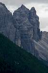
 The southern part of the Habicht Serles Group by wuedesau The southern part of the Habicht Serles Group by wuedesau |
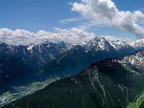
The Ridges between the big, bulky Habicht and the pointy Serles compose one of the north-western subgroups of the Stubai Alps. They are located between Stubaital Valley in the north-west and Gschnitztal Valley in the south-east, which are connected by Simmingjöchl Saddle. The saddle separates the group from the Stubai Alps Main Ridge in the south. In the north, the subgroup opens up towards the Inn Valley and Innsbruck with the ski areas of Neustift and Fulpmes at its base. Most likely the northern view across Innsbruck towards Habicht and Serles, which you see on the signature photo, is one of the most popular ones of the whole Stubai Alps.
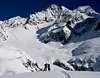
Basically the group is made up from two ridges. Two ridges which couldn’t be more different in almost any respect. Habichtkamm, the crest, which runs from Simmingjöchl Saddle towards Elferspitze above Neustift, is made up from eruptive types of rock: granite and gneiss prevail. Around Habicht, the highest mountain of the group, between Glättespitze and Schaufelspitze, there are some smaller glaciers, Habichtferner being the most prominent one. Towards the north, at the northern end of the crest, Elferspitze is made up from limestone, whith a solid base of eruptive rock. Of the mountains of Habichtkamm, only three are regularly climbed: Habicht (a relatively easy mountaineering effort), Zwölferspitze (a hike) and Elferspitze (two ferrate). Elfertürme to the north-east of Elferspitze, are rather popular climbing destinations.
Separated by Pinnistal Valley, which culminates in Pinnisjoch Saddle, a completely different crest awits you. Here, starting at Kalkwand, a limestone ridge runs north-westward towards Serles: Serleskamm. Almost all summits are reachable by hiking trails, sometimes exposed, sometimes protected ferrate. The ridge is much lower, its highest summit Kirchdachspitze, lacks 450m in height, compared to Habicht. Consequently there are no glaciers on the ridge. Serles, most likely is the most popular of the mountains, thanks to its proximity to Innsbruck and the ferrata which leads to its top. At its northern base you find a popular hiking area, which is quite crowded on any summer weekend.
The most important hut of the group is Innsbrucker Hütte. It is located in Pinnisjoch Saddle between the two ridges. Nürnberger Hütte serves the southern end of the group and Elferhütte and Padasterjochhaus serve the two northern ends of the respective crests.
2 – The Habicht – Serles Group on SP
  |
- Habichtkamm
- Serleskamm
3 - The Summits
 Schematic map of the Habicht-Serles Group |
- Innere Wetterspitze (3055m)
![]()
- Äußere Wetterspitze (3070m)
- Südliche Rötenspitze (2982m)
- Nördliche Rötenspitze (2924m)
- Ochsenkogel (3033m)
- Glücksgrat (2954m)
- Glättesspitzen (3134m, 2894m)
- Habicht (3277m)
![]()
- Schaufelspitzl (2834m)
- Manteler (2811m)
- Keldererspitze (2694m)
- Schafspitze (2661m)
- Zwölferspitze (2562m)
- Elferspitze (2505m)
- Elfertürme (2490m, 2495m)
3.2 - Serleskamm
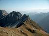
![Kesselspitze (2728m), Serles (2717m)]() Kesselspitze and Serles
Kesselspitze and Serles - Kalkwand (2564m)
![]()
- Ilmspitzen (2692m, 2690m)
![]()
- Kirchdachspitze (2840m)
![]()
- Hammerspitze (2634m)
- Wasenwand (2563m)
- Roter Kopf (2527m)
- Kesselspitze (2728m)
![]()
- Lämpermahdspitze (2595m)
- Blaser (2241m)
- Peilspitze (2398m)
- Rote Wand (2524m)
- Serles (2718m)
![]()
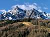
3.1 - Habichtkamm
 Glättespitze and Habicht
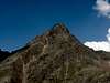


4 - Getting There
 Habicht
The group is easily accessible from Brenner motorway E45. Either head into Gschnitztal Valley to the south of the group or Stubaital Valley to the north
- Take Brenner Motorway E45 from Innsbruck.
- At Schönberg turn off onto B183 into Stubaital.
- Alternatively at Steinach turn into Gschnitztal.
5 - Accommodation
As for mountain huts, you can find the complete list on the Stubai Alps main page
6 - Red Tape
There is no Red Tape to speak of. There are ski lifts to the north of the two chains in front of Serles and Elferspitze . Here, also meadows and forests are used for sheep and cattle grazing. You’ll find fences with gates through which the regular hiking routes run. The meadows are private or municipal property but as long as you stay on the paths you are allowed to cross them. Close the gates wherever you find them open.7 - Weather Conditions
8 - Maps & Books
8.1 - Maps
Kompass has some very good overview maps, scaled 1:50000 which show all the necessary trails but don't go into too much detail:
- Stubaier Alpen
Kompass Map WK83
1:50000
ISBN: 3-85491-092-4
Better are the maps by the German Alpine Club, available for the nothern (Austrian) part of the Stubai Alps. They are scaled 1:25000 and can be obtained by The DAV-Shop (look under "Zentralalpen"). Both hiking and ski-touring trails are marked on these maps.
- 31/1 Stubaier Alpen, Hochstubai
8.2 - Maps Online
8.3 - Books
- Stubaier Alpen
W. Klier
Alpenvereinsführer
Rother Verlag
ISBN: 3-7633-1271-4
- Rund um Sterzing
Henriette Klier / Walter Klier
Rother Verlag
ISBN: 3-7633-4167-6