
-
 27436 Hits
-
 90.12% Score
-
 31 Votes
|
|
Mountain/Rock |
|---|---|
|
|
38.45987°N / 122.55343°W |
|
|
Sonoma |
|
|
Hiking |
|
|
Spring, Summer, Fall, Winter |
|
|
2730 ft / 832 m |
|
|
Overview
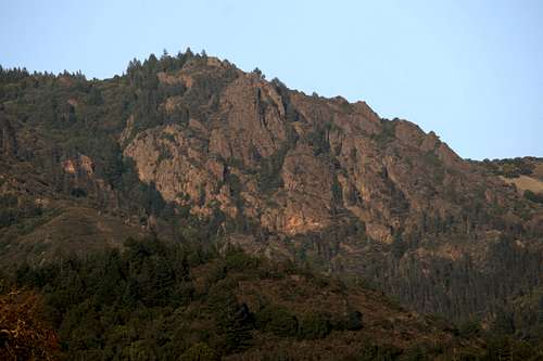
 View of Hood Mountain from Kenwood
California’s wine country is known for productive vineyards, redwoods and Sonoma County’s dramatic coastline, not for peaks with staggering views and rugged, rocky faces. Hood Mountain offers the exception to this rule, boasting not only impressive views of much of the Bay Area and a dramatic rock face, but also an unusual pygmy forest, attractive ponds and meadows en route to the summit, historic homesteads, beautiful creeks and wildflowers (in season) and the opportunity to backpack in a wilderness environment just miles from the Santa Rosa urban area. The sum of these attributes makes Hood Mountain one of the premiere peaks of the Wine Country and the greater North Bay Area.
Hood Mountain is one of the southernmost peaks in the Mayacamas Mountains. The Mayacamas are a subrange of the North Coast Range, extending south from the Russian River as it flows out of Potter Valley to the marshes along San Pablo Bay, a total distance of over 80 miles. Though long, the range is not particularly high, the tallest summits being Cobb Mountain and Mount Saint Helena, both reaching over 4,000 feet. The northern half of the range forms the divide between waters that flow directly into the Pacific Ocean and those that are part of the Sacramento River watershed, which flows into San Francisco Bay. The southern part of the Mayacamas forms the divide between the Napa River and Sonoma Creek. Though it is attached to the Mayacamas Mountains near Mount Saint Helena, the mountains forming the eastern wall of the Napa Valley do not seem to be considered a part of the range. One especially interesting aspect of the Mayacamas is that they contain the Geysers, the world’s largest geothermal production area. At its peak, it produced 2,000 megawatts, enough to power 2,000,000 homes.
 The view towards the northern Mayacamas from Gunsight Rock
The Mayacamas Mountains have a surprising amount of public land, both in the northern and southern portions. In the south, the public land is centered on a complex of parkland consisting of Sugarloaf Ridge State Park and Hood Mountain Regional Park. The regional park is owned and operated by Sonoma County. The two contiguous parks contain a combined area of 5,770 acres with more additions in the works. Though managed separately, there is a lot of cooperation between the two parks, with trails crossing the borders on a regular basis. One of the three routes to the summit of Hood Mountains begins in Sugarloaf.
As noted previously, the southern Mayacamas form the divide between the Napa River and Sonoma Creek. Hood Mountain is the highest point on the divide. Nearby Bald Mountain, in Sugarloaf Ridge State Park, is only one foot shorter. The difference between the two peaks could not be more dramatic. Bald Mountain is a grassy knob just west of the main crest of the Mayacamas. In contrast, Hood Mountain is well west of the crest, giving it a much more prominent appearance. This is augmented by the fact that the mountain towers 2,000 feet above the Valley of the Moon, from which the peaks rocky western face is visible. The western face is the most distinguishing characteristic of Hood Mountain. Composed of volcanic rock similar to that found in the Saint Helena/Palisades area, the craggy cliffs rise nearly 700 feet, an exceptional amount for this part of California. The crags are topped by Gunsight Rock, an exposed pair of rocks from which spectacular views of the Bay Area are possible. Though not as high as the true summit of the mountain, any trip to Mount Hood is incomplete without visiting Gunsight Rock, since the views are much better from this vantage point.
 Gunsight Rock
Other than the exposed stone around Gunsight Rock, the rest of Hood Mountain is covered in thick forest. The bulk of the woods are typical California oak woodlands, which includes bay, madrone, Douglas-fir and others in addition to oak. On the northeast side of the mountain is a large pygmy forest consisting of stunted knobcone pines and Sergent cypress. The trees in the pygmy forest rarely exceed 15 feet in height, an effect of the unwelcoming soil the tree have to grow in.
Hood Mountain also has two small ponds not far from its summit. Merganser Pond is impounded water with a rocky pinnacle rising above its western shore. One of the two backcountry camping location found on Hood Mountain is located 100 yards east of the pond. Just above Merganser Pond is Blue Heron Pond. While the former is man-made, the latter seems to be a spring-fed pond. Just above the two ponds is a large meadow and orchard, as well as the remnants of an old homestead.
The best views on Hood Mountain are actually from Gunsight Rock. From there the Valley of the Moon spreads out to the north and south. The Sonoma Mountains, including Bennet Peak, Taylor Mountain and Sonoma Mountain are on the far side of the valley. Santa Rosa and the Coast Range are on the western horizon and to the north Geyser Peak, Saint Helena and much of the rest of the Mayacamas Mountains are visible. The views to the south include Mount Tamalpais, Mount Diablo, Sulphur Springs Mountain (by Vallejo) and distant Mission Peak (near San Jose). San Pablo Bay, Oakland, San Francisco can be observed, as can the Bay Bridge and the San Raphael Bridge.
 Alpenglow on Gunsight Rock
A note on the name of the peak
There is a discrepancy regarding the name of the peak. All USGS maps list the peak as Mount Hood. Locally, the mountain is identified as Hood Mountain. This is evidenced by the name of the park in which the mountain is found and by plaques on the summit. While both seem perfectly acceptable, the local name is used here on Summitpost to avoid confusion with the much more famous Mount Hood in Oregon. Hood Mountain was named after a local pioneer who homesteaded on the mountain.
Hood Mountain Map
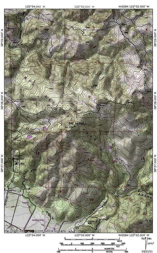 Hood Mountain Area
Routes
 Ridges climbed by the Goodspeed-Nattkemper Trail
Three trails lead to the summit of Hood Mountain. Two trails approach from the south. The first is the Johnson Ridge Trail, which winds its way up Hood Mountain Creek Canyon. The second route, the Goodspeed-Nattkemper Trail begins in Sugarloaf Ridge State Park and climbs the southern face of the mountain. The third route, the Summit Trail begins on the north side of Hood Mountain. All three routes gain approximately 2,000 feet of elevation.
Hood Mountain Trails Map
 Hood Mountain Trails
Getting There
 Two routes to Hood Mountain begin in the Valley of the Moon
Directions to the three trailheads:
Summit Trail:
From Santa Rosa, head east on Highway 12. Turn left on Los Alamos Road and follow it for over 5 miles to its end at the marked trailhead.
Johnson Ridge Trail:
From Santa Rosa, head east on Highway 12. Turn left on Pythian Road and follow it for over 1 mile to its end at the marked trailhead.
Goodspeed-Nattkemper Trail:
From Santa Rosa, head east on Highway 12. Turn left on Adobe Canyon Road. Look for the trailhead on the left just after crossing the Sugarloaf Ridge State Park Boundary.
Red Tape
 Blue Heron Pond, on the north side of Hood Mountain
There is a $6.00 dollar fee at the two Hood Mountain Regional Park trailheads (Summit Trail and Johnson Ridge Trail). The Goodspeed-Nattkemper Trail trailhead is located prior to the pay station in Sugarloaf Ridge State Park.
The trailheads at Hood Mountain Regional park are closed after sunset.
Although there are some service roads along some of the routes to the summit of Hood Mountain, it is managed as a wilderness park. Normal wilderness rules and ethics apply. There is some private property, especially at the beginning of the Johnson Ridge Trail. Please be respectful when passing homes.
Camping
 Backcountry campsite adjacent to Merganser Pond
There are two backcountry campsites on Hood Mountain. One is on the Summit Trail, the other on the Johnson Ridge Trial. The nearest campground is at Sugarloaf Ridge State Park, which is just south of Hood Mountain. There is also a campground at nearby Spring Lake Regional Park in Santa Rosa.
External Links
Hood Mountain Regional ParkTrailmap for Hood Mountain area.
Bob Burd - Mar 23, 2011 8:54 pm - Voted 10/10
NamingConfusing, to be sure. It's called "Hood Mountain Regional Park" but the name is officially "Mt. Hood" in the USGS/BGN records.
Bubba Suess - Mar 23, 2011 10:19 pm - Hasn't voted
Re: NamingI agree, it is confusing. I went with the Hood Mountain form as I grew up in the mountains shadow and all the locals all refer to it as Hood Mountain, as the name of the park and a plaque on the summit placed by the Hood family indicates. Plus it reduces possible confusion with the Mount Hood. Also, the previous entry on SP was Hood Mountain. However, I do like getting things right. Any suggestions how to rectify it?
Bob Burd - Mar 24, 2011 1:45 am - Voted 10/10
Re: NamingIf it were up to me, I'd change it to Mt. Hood because I like the officiousness of the BGN. It's also the name you'll find on topo maps and google and peakware and other online resources. But your reasons are good, too (except the part about confusing it with the other Mt. Hood - that's a generic problem with many similarly named mtns, but probably not a good reason to change one of them, imho). In the end, it's not up to me because my lazy ass didn't make the page, you did, and you already put some thought into the issue. So I'd suggest doing what *you* think is best. If you decide that what you have currently is most appropriate, I'd suggest adding a short note about the name so you don't get more of this same correction in the future. :-)
Marmaduke - Nov 7, 2017 11:48 am - Hasn't voted
Sonoma Valley FiresA note, the entire area burned, all trails are temporarily closed.