-
 29527 Hits
-
 83.1% Score
-
 16 Votes
|
|
Mountain/Rock |
|---|---|
|
|
38.66379°N / 122.19044°W |
|
|
Yolo |
|
|
Hiking |
|
|
Spring, Summer, Fall, Winter |
|
|
3057 ft / 932 m |
|
|
Overview
Berryessa Peak at 3,057 feet (931 meters) is the second highest summit in Yolo County, California. Berryessa Peak is also the highpoint of Blue Ridge; a small mountain range?/ridge east of Lake Berryessa that runs in a north-south direction. Berryessa Peak was once thought to be one of the highest points or the highest point of Yolo County. That distinction now belongs to Little Blue Peak. According to Gary Suttle in California County Summits: "mountaineer John Sarna discerned the true highpoint on a topo map in 1991."
While Berryessa Peak is located on Bureau of Land Management (BLM) land, for many years the summit had no public access as surrounding land was on private property. In September 2008 a private landowner allowed a public trail easement for access to the summit and the 9,100 acre "landlocked" Berryessa Peak BLM land. If Dingus Milktoast is correct (per the quote on the Summitpost Little Blue Peak page), then this 9,100 acre piece of BLM land was the largest piece of general use public land that was inaccessible to the public in the United States.
This BLM land is administered by the BLM Ukiah field office. In recent years, the good people associated with the Yolo Hiker and Tuleyome organizations have been built a trail to the summit of Berryessa Peak. The peak is also a peak found on the California Coastal Peaks List. According to Peakbagger.com's webpage on Berryessa Peak, the peak has a Clean Prominence of 1377 ft/420 m and an Optimistic Prominence of 1417 ft/432 m. Berryessa Peak serves the hydro-graphic drainage basins of Sacramento, San Francisco Bay and the Pacific Ocean.
Berryessa Peak is also ranked #51 of California County Prominence Peaks. Update: Yolohiker.org now has a page on their website for the Berryessa Peak Trail which includes a map and GPS track. Link here. Tuleyome.org now has a Berryessa Peak trail info page located here.
Getting There
Get to the north end of Lake Berryessa. The Berryessa Knoxville Road is paved along the north shore. Head northwest on the Berryessa Knoxville Road. At the point where the Eastside Road intersects with the Berryessa Knoxville Road (set your odometer here) it is 1.5 miles to the trailhead.
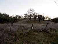
At the trailhead you should be able to see a faint dirt road heading northwest. Looking southwest you should be able to see the faint remnants of an old road/trail. See picture in the images section. Also Google Maps gives this location at Lat 38.703178, Long -122.266148.
Also, Yolohiker.org's Berryessa Peak Trail webpage has supplemental information on getting to the trailhead as well.
Red Tape
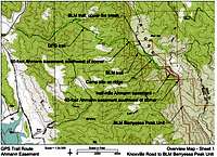
No apparent or special regulations for hiking in the BLM portions of the trail. It might be wise to check with the BLM office in Ukiah for any special regulations for hunting. Also note that some portions of the trail may be on land that is co-managed by California Department of Fish and Game (see "DFG Trail" on the image map)
Please respect all private property, private property public easements and posted signs.
Camping
Camping/backpacking is possible on BLM land. However, creek water/flows may be nonexistent in summer months and limited even in winter months.
The closest developed campgrounds are at Lake Berryessa. The campground management and access has changed in recent years (and may continue to change into the future). It might be wise to double check with Lake Berryessa Field Office and Visitor Center regarding up-to-date campground availability.
The Hike
The hike is about 7.25 miles one way or 14.5 miles round trip. The total elevation gain is a little under 3,500 ft, As of December 2011, the trail is fairly straightforward. Be aware that about 1.6 miles into the hike the trail runs into an important intersection. You should take the trail to the right. The correct trail heads uphill and back to the west. Look for the green horseshoe section right below the words "BLM trail, upper.." on the topographic map in the images section.
Trekking poles might be useful on the hike as there are several steep sections of the trail. The round trip took our party going at a moderate pace 7 hours 45 minutes with about 2 miles of bushwacking. With the completion of the official trail, the time to do the hike will surely decrease.
Yolohiker.org now has a page on their website for the Berryessa Peak Trail which includes a map and GPS track. Link here.
Note: see updated map on the Yolohiker.org website here. A trail elevation profile is available here.
The View
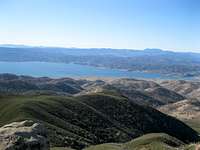
If you ignore the communications towers on the summit the view is very, very cool. On a clear winter day you can see:
To the northwest: Mount Lassen
To the north: Snow Mountain (and beyond)
To the east: Sierra Buttes, the Crystal Range/Tahoe Peaks, Sutter Buttes
To the south: Mount Diablo, Mount Tam and others
To the west: Mount Saint Helena, Sugarloaf Ridge State Park peaks and others
Check it: Krt's view from the summit of Berryessa Peak panorama. Sweet...
Place Names
Berryessa Peak takes its name from Berryessa Valley. According to Erwin G. Guide in California Place Names : "The valley preserves the names of Jose Jesus and Sisto Berryessa, soldiers in the San Francisco company and grantees of Rancho Las Putas in 1843." According to Gary Suttle in California County Summits: "Blue Ridge..[is] named for the the bluish cast of its blue-oak woodlands and chaparral."
Other Recommended Area Peak Hikes
Mount Konocti
Mount Saint Helena
Fiske Peak also here
Lowrey Peak
Balley Peak
Something completely different...?
External Links/Other Stuff to Do...
Bureau of Reclamation: Lake Berryessa
Good overview jpg map of the lake area, resorts, concessions and facilities - pdf version here
http://yolohiker.org
http://www.tuleyome.org/
Cedar Roughs Wilderness Area
Berryessa Vista Wilderness Park
Calif. Dept. of Fish and Game: Lake Berryessa Wildlife Area
Wilbur Hot Springs
Creek Freaks, your links are here: Cache Creek whitewater Putah Creek whitewater
Berryessa Snow Mountain.org's Info on Berryessa Peak and Lake Berryessa Paddle Guide and Map
For Engineering/Telecommunications Geeks
Lake Berryessa on Wikipedia
Berryessa Peak on Peakbagger.com
Sacramento Bee news article on the Berryessa Peak Trail
Bob Burd's Berryessa Peak trip report (it's never a dull moment with Bob :)
The Duffle Bag's Berryessa Peak Hike (good pictures)
Check out SP's very own Jibmaster getting his Jib on with mountain bike video footage on the Berryessa Peak trail
Getting high in Napa County [that's MTB not THC]
The One and Only Dingus Milktoast's Berryessa Dreams on Supertopo.com
Konocti Regional Trails
BLM contact information:
Bureau of Land Management
Ukiah Field Office
2550 North State Street
Ukiah, CA 95482
Phone: (707) 468-4000
Fax: (707) 468-4027
Office Hours: 7:45 a.m. - 4:30 p.m., M-F
Need an additional challenge?
Considering dirt running the trail round trip. It makes a great training run for your Lake Sonoma 50.
Small world....LT likes running BP
Fastest Known Time attempt(s) on Berryessa Peak trail?
The ascent didn't quite feed your rat? How about a little IM Long Course thrown in for good measure? Lake Berryessa-based 70.3/140.6: Option #1, Option #2
Have a successful summit experience? Why not enjoy a view of your accomplishment from the northwest shore at mile mile 70-75 or perhaps delightful Capay Valley at mile 165+?
Boogie with Stu?
Boggs Mountain Boogie
Hey, Diamond Tooth Gerties she ain't, but if you must visit Capay Valley's "House of Sin", your link is here.
Beer stop to the east of Berryessa Peak?: Berryessa Brewing Company
Elmshaven
Robert Luis Stevenson Museum
Lastly, If you always wanted to experience an "italic shogunate" and are willing to drive a little bit westward to booze it up in an Italian castle, this link may interest you..


