

-
 16251 Hits
-
 92.85% Score
-
 40 Votes
|
|
Mountain/Rock |
|---|---|
|
|
46.28924°N / 13.59362°E |
|
|
Slovenia |
|
|
Hiking, Skiing |
|
|
Spring, Summer, Fall, Winter |
|
|
5817 ft / 1773 m |
|
|
Overview
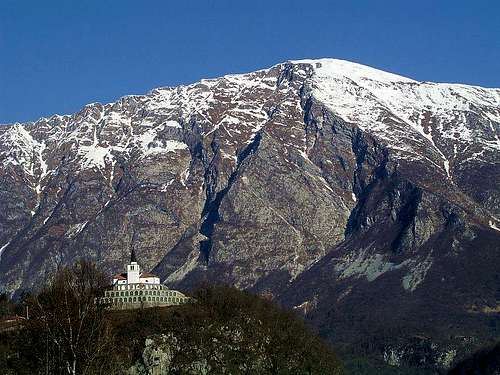 Krasji vrh from Kobarid
When Soca river trudges on her way toward Adriatic Sea a long ridge forces her to make a big detour. This mighty ridge is named Polovnik. And Krasji vrh ( Kras peak ) with his 1772m is the highest point of this wild and little visited ridge. It stretches from the East towards the West in lenth of 9km. Actually as Polovnik is referred only the westeren part, the higher eastern part, on Dreznica side, is named Morizna. However, among mountaineers the name Polovnik is used for the entire ridge.
Other summits on the ridge are (from Bovec - westeren side): Mali Polovnik, Veliki Polovnik (1471m), Nad Pecem (1458m), Spik (1482m), Pirhovec (1660m), Veliki vrh (1764m).
Along the entire ridge there are mountain pastures: planina (mountain pasture) Zaplec, planina Zaprikraj, planina Predolina are below Krasji vrh, planina Dolec is below Veliki vrh and Pirhovec, planina Polovnik is below Veliki Polovnik and Nad Pecjem. A beautiful view on bold and precipitous slopes of the ridge is from Kobarid, especially from Kobariski Stol and from the road toward Bovec. From Bovec side Polovnik shows as covered with rich forests, completely opposed as from Kobarid side wich is almost bare.
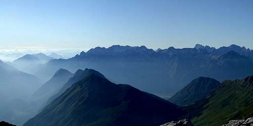
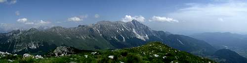 View from summit toward east
View from the summit is gorgeous...Krn, his westeren wall and his entire ridge is toward the east in front of us, long ridge of Kobariski Stol and Julian prealps to the west, Kanin group to the north and beyond it Vis and Montaz group and all giants of Julian Alps. And 1300m below us the wondelful emerald tape of river Soca. At a clear day you can see Adriatic Sea toward the southwest.
History
 Monument
 Ornamental pillar
Like the entire range of Krn group and the westeren part of Julian Alps also Krasji vrh and the entire ridge of Polovnik is marked with remnants of the 1st world war (military trenches, bridle paths and caves), wich mercilessly raged on this enormous battlefield . The most known is the 12th battle by Soca river, in wich in 24 October 1917 German and Austro-Hungarian divisions pushed the Italian opponents all the way to the river of Piave.
On Krasji vrh the Italian army had outposts with antiarircraft guns, which were shooting on reconnaissance aircrafts.
If you are perhaps more interested for the history of 1st world war, visit Kobarid museum, which got the museum prize of Council of Europe for the year 1993 or MUZEJSKA ZBIRKA (museum collection) "Batognice" , Dreznica 22a (in the centre of village Dreznica), tel: +386 (0)5/384 86 01 (private collection)
Getting There
 river Soca
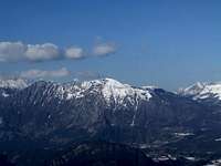 part of Polovnik ridge
Kobarid and Soca valley can be reached from the south ( from Italy via Gorizia, from Slovenia via Idrija or Ajdovscina ) or from the north ( over Vrsic Pass from Sava valley or over Predel pass from Tarvisio ). It's also possible to arrive there from the west, from Udine over the Ucja/Uccea pass or from Udine via Cividale and then over Stupizza pass - these routes are reaching Kobarid and then villages Dreznica and Drezniske Ravne.
Routes lists
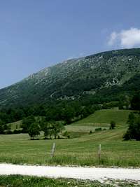 Krasji vrh from southeast
 on way
- From Drezniske Ravne (635m): Start to above the village where the sign with drinking water stands. At first detour take the marked path which crosses the road, as we don't need to walk by road. At first crossroad turn left (labels) and continue through a forest to the next crossroad on the altitude of 1450m. Here we have on choice two ways which lead us on the summit. Right way leads around the forest, the left one by an open world. Easy path. Nice ski tour in winter.
Time Required: Drezniske Ravne - Krasji vrh (1773m) - Drezniske Ravne = 5h.
- From planina (mountain pasture) Zaprikraj (1200m): We drive by a road on Drezniske Ravne, where the asphalt road ends. From there we continue by a bad, macadam road to planina (mountain pasture) Zaprikraj. From there the path goes by the old military path and leads us by a hunting lodge and monument of NOB (nationally liberation commbat). The path continues to the next crossroads at the altitude 1450m, where it splits up on the left and right branch. They both can bring us on the summit. Easy path. No water! Nice ski tour in winter.
 on way
 Krn west wall
Time Required:
planina Zaprikraj - Krasji vrh (1773m) - planina Zaprikraj = 2h 30min to 3h.
Maps:
- Krnsko pogorje in Kobarid, Planinska Zveza Slovenije 1:25000
- Julijske Alpe, zahodni del (western part), Planinska Zveza Slovenije. 1:50000
- Posocje, 1:50000
- or click here (Krn subgroup interaktive map)
Red Tape
 eagle
eagle On way
The entire range of Polovnik is a cultural heritage of Slovenia. There are no restraints practically. We beg you, that you keep nature intact, don't tear flowers and if you find remains of weapons leave them there for your safety. Garbages also don't fit on mountains ;-)
When To Climb
Krasji vrh can be reached over the whole year. In winter it is necessary to be careful, because of the possibility of avalanches or iced slopes. Unannounced thunderstorms or fog need a necessary precaution also in summer. In August it is very hot on the western slope. view from summit toward west
Weather:
- ARSO (Slovenian)
- provreme (Slovenian)
- Wunderground ( English )
- Il Meteo (Italian) search for Udine
Huts & Camping
 Krasji Vrh from Krn
- Kamp Koren
- Accomodations in Dreznica and Drezniske Ravne
- Accomodations in Kobarid