|
|
Mountain/Rock |
|---|---|
|
|
34.49450°N / 119.7126°W |
|
|
Santa Barbara |
|
|
Hiking, Scrambling |
|
|
Spring, Summer, Fall, Winter |
|
|
3985 ft / 1215 m |
|
|
Overview
Although not as interesting as it's neighbor, Cathedral Peak, La Cumbre Peak is the highest peak on the Santa Ynez mountain ridge directly behind Santa Barbara. It serves as a great training hike and affords nice views of the Santa Barbara area coastline and the Santa Ynez valley.
Getting There
From downtown Santa Barbara, take State St to Mission St and turn right. Follow Mission St to Laguna St and turn left. Pass the Santa Barbara Mission and continue up Laguna St/Mission Canyon Rd for roughly one half mile to Foothill Rd and turn right. After several hundred yards (near the fire station), turn left on Mission Canyon Rd. Continue up Mission Canyon to a fork in the road. Take the left fork up Tunnel Rd and continue a couple of miles to the end of the road. Parking is available on the right side of the road. The trail begins on a paved access road just above the parking area.
Route
 |
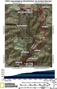
The paved access road is know as Spyglass Ridge Rd. Pass the metal gate and follow the road as it curves through Mission Canyon. After descending a hill and crossing a small bridge, the road becomes dirt. Follow the left branch and head up a hill. After 30 yards you will see the rusty sign for Tunnel Trail on your right at 0.75 miles from the trailhead. Follow Tunnel Trail until you hit a flat area where Power Lines Rd intersects the trail. Tend toward the left here and continue uphill. After a mile or so, Mission Falls, a 200 ft high water fall, will come into view from across the canyon. Although it is typically dry, after a good week of rain the flow is impressive. Continue on the trail, circling around the canyon, crossing the usually dry creek that feeds Mission Falls at 2.65 miles from the trailhead. Continue another mile to the intersection with East Camino Cielo. Turn left on East Camino Cielo and walk uphill on the road for approximately 1.3 miles. At this point, you will see a small driveway on your left that leads up to the summit area. There are several small tables and benches around the summit area from which to take in the view. To descend, reverse the way you came up or continue on to Cathedral Peak via the unmaintained connector trail to create a loop hike. See the Cathedral Peak page for a description. Round trip distance: 10 miles Elevation gain: 3155 ft |
Red Tape
The parking situation at the Mission Canyon trailhead is heavily monitored. Take care to park in designated areas only. An Adventure Pass is not needed to park at this trailhead, as it is outside Los Padres National Forest.
Camping
La Cumbre Peak is a day hike, so most likely camping will not be required. However, the nearby Los Padres National Forest offers excellent camping opportunities.
External Links
Ray Ford's Santa Barbara trail guide that contains excellent information on many other hikes in the Southern Central Coast region.
Another excellent source of information for Santa Barbara area hikes.

