Approach
“
FALLING!!” The word exploded from my core with a will of its own by habit or instinct. “ARREST!! ARREST!! ARREST!!” immediately followed as I became conscious of the fact that I was now accelerating downhill with a significant portion of the slope.
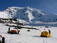
Wednesday morning shortly before sunrise Jim's alarm went off, and he, myself, John, and Jessica jumped up to grab our Hampton Inn complimentary breakfast before throwing our packs into the rental Chevy and hitting the road. I had worked out all the spreadsheets and considered all of the gear over and over, and still ended up with an approach pack weighing about 53 lbs. The drive from Seatac to White River Campground went quickly and I felt ready for what would be the greatest challenge of my climbing career. White River was completely vacant without a soul to be found. We filled out the requisite forms, shouldered our obscenely heavy packs, and departed on the Glacier Basin Trail at 8 AM sharp. The hike through the old-growth forest up to Glacier Basin was a wonderful experience for someone accustomed to the more arid climate of the Rocky Mountains' front range. Just as we reached the end of the trees we stumbled upon an area of total devastation. Dozens of large evergreens lay in splinters in a large area across the trail, still green and smelling freshly cut. A quick glance across the valley revealed the slide path which had run nearly 3000 feet off of Mount Ruth. We snowshoed quickly across the debris field and made our way towards St. Elmo's Pass.
The climb to the pass was to foreshadow the trip: post holing in knee-deep slush and setting off multiple small slough slides. After crossing the pass at about 1:30 PM, we roped up and began to traverse the lower Winthrop Glacier. The strange landscape passed by more or less uneventfully and after several hours we were climbing onto Curtis Ridge. We contoured around the seemingly endless ridge on ever-softening snow slopes as the day wore on. As we passed under a small cliff we set off about seven slough slides over about one hundred yards of hiking. Finally at 5:20 PM after almost nine and a half hours we reached the edge of the Curtis Ridge, set up camp, and contemplated our future. The ridge was in profile lighting in the evening and we counted the fracture lines (at least four) on the ridge as portions of the Willis and Liberty Walls collapsed in the evening warmth. John, Jim and I discussed how we felt about taking on the challenge. I felt like I was staring down the twin barrels of a twelve gauge. The phrase “crumbling deathtrap” came to mind and it was about this time that the chorus of Social Distortion's “Reach For The Sky” popped into my head. It was just the chorus, and it was stuck in my head for the next three days.
Lower Ridge
I never heard a “whoompf”, and didn't see the fracture line shoot across the slope six feet above me as I was setting myself for a short break. There was no sudden sense of motion, just a visual realization that I was accelerating, along with the slope under me which slowly and surrealistically morphed from a smooth slab to a jumbled mess.
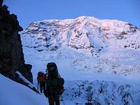
Thursday morning we started way too late, waking up at 3 AM and leaving camp around 5:15 AM. We were roped up and had scouted a path up the Carbon Glacier on the east side of the toe of the ridge. There was a faint boot track, but we couldn't see how it connected to the ridge. We figured by the time we got up the Carbon we'd have enough light to spot a route. After walking around many and through a few crevasses we arrived at a spot at the base of the east side of the ridge where the boot track disappeared into a rock and snow slide covered slope. We split into two rope teams and started up the slope. The rockfall was fairly continuous, the snow was deep and slushy, and I punched waist deep into a crevasse on the way up. Finally, we were on the ridge proper. The grueling nature of the climb to Thumb Rock is testament to my lack of memory of it. I was roped to Jim, and John and Jessica followed on our second rope. We hit one spot where there was some hidden ice under the snow that Jim slipped on. I was able to arrest him fairly easily in the soft and deep snow. After passing the obstacle I put my head down, found my rhythm, and at 2:15 collapsed at the Thumb and passed out for ten minutes. Our second approach day had taken another nine hours.
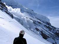
The sun beat down on us throughout the afternoon and evening and the shade of the Thumb was briefly braved at the risk of large rocks dropping from above. At one point an incredible noise alerted us to a massive avalanche ripping down the Liberty Wall all the way to the Carbon Glacier. We decided on a midnight wakeup to finally get an adequately early start. For our summit bid, we would forgo the hot breakfast and try to get moving as quickly as possible. Above the Thumb lay our three options. The snow slope to the right was cut by a fracture line perhaps a day or two old. The center path was poorly covered and looked like a crumbly horrible scramble. The left snow slope bore the blown remnants of a boot track, so we decided on the left route. As I drifted off to sleep I wondered how long our summit day would be and if the weather would hold for us. Once we ascended above the Thumb, retreat became a very unattractive option. That night I dreamed of a strange woman I sought just out of reach..
Upper Ridge
As I was yelling for a team arrest, I made my best attempt at my own. Fractions of a second passed by as I levered the pick of my axe deep towards the bed layer. I felt friction, and I cranked it in.
I stirred as Thursday became Friday. The thought had occurred to me when I was marking the trip on my calendar months earlier that our summit day was on Friday, May 13th. I'm not superstitious, but this trivial fact did not escape my notice. We pulled down the tents, roped two by two, and set off left and up in snowshoes. The route quickly became a steep traverse in the predawn darkness, and wishing for the improved stability of crampons I placed my first picket several hundred feet up. If we had light to show the 1500 foot drop to the bottom of the Willis Wall I might have placed a few more. It's funny how climbing in the dark can give the feeling of greater security by reducing distracting exposure. After clearing the traverse, we climbed back to the ridge and traded our snowshoes for crampons. Once again, we put our heads down and climbed higher. Jim, John and I traded leads as we gained and surmounted the snowfield near the Black Pyramid. Above this, the slope mellowed out enough for a good break and we spotted the boot track again. We followed it near an ice cliff on the left that must have been 60 or 70 feet tall. Leading on, I hit an area of waist to chest-deep soft sugar snow which made progress nearly impossible. After I gave up on my route, John found a slightly more stable route through the mess and we were soon rounding the corner to behold the bergschrund. As John brought us up to the ice we noticed a jumbled mess of unattractive snow and ice to the right side, probably fifty feet tall or higher. The ice became cleaner and lower angled off to the left. We joined the ropes and picked a probable line about twelve feet high, at around 65 degrees, and I grabbed my alpine tool and the crappy titanium screws.
![Leading Liberty Cap Schrund]()
![John starting up the...]()
By this time it was around noon, the sky was mostly white, and a light snow was beginning to fall. Jim built an anchor and belayed me over to the line. I placed one screw as high as I could, clipped it, and started up. I don't consider myself to be much of an ice climber, so my plan was to flash the line as quickly as possible without stopping to place any pro. The route was not very high, the landing was soft snow, I had a belay anchor and one good screw in, so I attacked. About five minutes later I pulled over and collapsed into the soft snow above the ice. After catching my breath, I hiked up about twenty feet and set an anchor to bring up the rest. The snow was soft, so I placed a deadman picket, my axe, and my tool and equalized them before putting Jim on a munter hitch directly on the anchor (bad call). Jim started up and fell. The anchor held. He started up again and fell again. The anchor held. He started up one more time and fell one more time. Very quickly the entire anchor setup ripped from the soft snow and suddenly I was accelerating towards the edge dragging a picket, axe, and tool behind me.
One foot from the edge, the pull stopped as Jim hit the soft snow below the route. “Nice arrest!” Jim said as he stood up and brushed off the snow. I opted to not tell him at that moment that I actually didn't arrest the fall. This time I built the anchor right. I placed a screw in the strong ice at the top of the 'schrund, built a similar anchor behind me (picket, axe, and tool, dynamically equalized), planted my feet solidly behind the lip of the ice, and belayed him off my harness. In this arrangement I was able to hold him on top rope without even weighting the anchor, leaving it as a backup. Jim climbed to the top with a few falls, followed by Jessica and then John, each taking several falls as well. Then we were up. It took too long, but we had only snow slopes and white skies above.
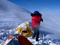
The snow was falling more heavily, the wind was picking up, and it was around 1 PM. As visibility declined, we ascended. Fortunately, there were no great obstacles to overcome and before long we were standing on a local maxima. We were on Liberty Cap at 1:39 PM. Now we had to navigate in what was quickly becoming a whiteout to the connecting saddle between the top of Curtis Ridge and Columbia Crest. Jim pointed me in the general direction and we walked into the white. I could only see a few feet and avoided sharp drops by watching the bits of snow I kicked in front of me as I walked. When they started disappearing, I turned. I would walk for a while in a direction and when I got off the bearing Jim would tug the rope to get my attention and point with his axe. This seemed to go on forever in a white world without variation of sight or sound. Between my obstacle avoidance and Jim's compass navigation, we eventually got to a relatively flat area where my altimeter read 13800 feet. It was now 4:30 PM and we had been climbing for fifteen hours. Jim made the correct call to end the march and setup camp before we were completely spent. At this point we were in enveloped in a ground blizzard and put all our efforts into building shelter. Having read trip reports of disaster resulting from lost and destroyed tents, we worked together to minimize the risk of loosing one of ours. We got the VE25 and the Trango 2 up without problems, anchored them with pickets, and crawled in. Having two stoves, we put one in each tent's vestibule and separately melted snow, made dinner, and went to bed. I was glad I had lugged my fleece pants and down jacket all the way up as I wore them inside my down bag Friday night.
Upper Descent
As my pick barely scraped at the hard bed under sliding snow I felt tension on the rope. I slowed and the snow continued to pass by me. As soon as it had started, it was over and I was in arrest on the bed layer, tied to a tensioned rope, with the sound of several tons of sliding snow slowly dumping into the broken crevasse field below.
Saturday morning I woke up to a headache, the sound of high winds and blowing snow, and a Jennifer Lopez lower lip. We were still in a whiteout. As I dug around for my Advil, Jim jumped out and started shoveling out our Trango 2. The vestibules had nearly completely collapsed from blown snow, and one side was drifted up pretty well, but both tents had held out. As I was getting my gear on, I heard someone cry “Blue Sky!!”. Jim was seeing breaks in the weather and we would be able to confirm our location. I joined him as the clouds were intermittently breaking. As Jim, John, and Jessica broke camp, I hiked over to a saddle which turned out to be our destination from the evening before which we had missed by only a few hundred feet. Knowing that we might loose visibility again and still had to negotiate the Emmons-Winthrop Glacier route (which we had not ascended and were unfamiliar with), we got moving as quickly as we could. However, because we slept in after our long summit day, we didn't leave camp until 10 AM. I could see the clouds below, blanketing the region in growing cumulus threats. We roped into one team, headed for the saddle, and decided to head down a depression to the east (very bad call).
![After the slide, rope is...]()
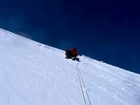
![Descending the...]()
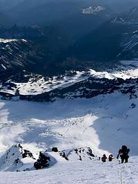
The actual Emmons-Winthrop route descends to the northeast on a higher area between the two glaciers. We were descending into the crevasse field between the Winthrop Glacier and the Russel Cliffs. This is not a good place to be. All the while visibility was coming and going, but we never got a complete look at where we were headed. After descending from the saddle about 500 feet, we got a good look at where we were headed and it was ugly. Broken crevasses, old avalanche slides, cliffs and rockfall littered the depression. We had to work further east. We decided to cross cut the slope we were descending in order to get back on route (terrible call). I started the traverse and after maybe one hundred feet stopped to take a one minute breather. I kicked my feet in for a rest and that was when the entire slope cut loose. The crown was deeper than an axe (two to three feet), maybe one hundred feet wide, and ran down thousands of feet into the broken crevasses. I had been very near the top, had slid about fifty feet, and had not been buried. Jim had seen the fracture shoot over to and above him and was caught in side of the slide. Jessica was pulled down a short ways and managed to get a good self arrest. When John heard the yelling he stabbed the spike of his axe as deep as he could in a self-belay and braced himself. Tension came on the entire rope, between all of us, and John had held it. He didn't end up weighting the axe but held the remaining tension with his legs. They had team arrested an avalanche that saved my life.
Rather than take any more chances, we climbed a couple hundred feet back straight up the slope above and to the right of the slide area until the slope mellowed to under the critical angle and became more stable. Again we cut across knowing that our only way out was by reaching the Emmons-Winthrop. This time we made it quickly and without excitement to the higher area on the northeast slope of the summit. We picked our way down the route in intermittent visibility and got our first glances at Steamboat Prow and Camp Schurman. On lead, I punched through several soft snow bridges but never sank deeper than my waist. Fortunately we never had to set up a rescue pulley. We made pretty good time going down, but knee deep post holing kept us at a modest rate. About halfway down I noticed a large (50 foot) crevasse lip/ice cliff off to my right and a similar one to the left. Ahead appeared to be a gentle convex slope but I noticed that the little snowballs coming off my feet were disappearing as they rolled ahead. I stopped about 50 feet above that point and realized we'd have to climb back up and make a long end run right. We reversed the team and John lead us around onto safer slopes. The lower we got the better the conditions got. Eventually we had clear conditions and an excellent view of the rest of our descent.
Lower Descent
![Steamboat Prow and Camp...]()
We reached Camp Schurman around 6 PM and took a short break. Then it was up and over the pass to Interglacier. Below the safety of the Prow, we unroped and plunge stepped down the snow. There were fresh boot tracks and ski tracks all over. I fantasized about strapping on my snowboard and slopping out wet slushy turns all the way down.. Instead, we plunged knee deep about halfway down until we ran into the first other people we'd seen in three and a half days. After chatting for a bit, we plunged down to the steepest section of the slope. Spotting a glissade path, I flopped down in it, pushed off, and enjoyed the most satisfying glissade ever. We dropped almost one thousand feet in minutes and the sheer joy was indescribable. We continued to Glacier Basin Camp, met another group, and chatted some more. A sweet angel among their group offered me a chocolate chip cookie, and it was one of the greatest rewards of the whole trip for me. I can't thank her enough for that simple cookie which I split with Jim. Three miles later we were back at the car at 8:30 PM. The whole ordeal had taken almost exactly three and a half days. On those days we had hiked nine and a half hours the first, nine hours the second, fifteen the third, and ten and a half the fourth. Forty four hours of climbing with a fifty pound pack and several very close calls left us fairly depleted, but we had survived.
When I first climbed the Kelso Ridge of Torrey's Peak in winter, I jokingly said “Now I am a man”. After Liberty Ridge, I know I am just a child, and a foolish lucky one at that. I gained great experience and have new views on mountaineering and alpinism that will influence my choices and decisions for the rest of my climbing career. In the best of conditions, this climb might be grueling. In the worst, terrifying. I feel as though I have been taught very important lessons which I will remember forever, and I am grateful that my instructor was as forgiving as she was.


Comments
Post a Comment