
-
 8424 Hits
-
 85.36% Score
-
 20 Votes
|
|
Mountain/Rock |
|---|---|
|
|
47.09625°N / 11.11529°E |
|
|
Mountaineering, Skiing |
|
|
Spring, Summer, Fall, Winter |
|
|
10824 ft / 3299 m |
|
|
Overview
 Lisenser Fernerkogel as seen from Längental
Standing high above the Lisenser valley to the north and the beautiful Längental to the west, Lisenser Fernerkogel (also: Lüsener or Lüsenser Fernerkogel) is widely known as the highest mountain of the Sellrain subranges within Stubai Alps .
However, geographically correct, Lisenser Fernerkogel belongs to the Alpeiner subgroup and to the Schrankogel subrange , where it is by far not the highest peak.
Nevertheless among Innsbruck and Munich (and surely many other) ski hikers, Lisenser Fernerkogel is a spring ski classic. On sunny weekends the first start at 04.30 a.m. and finish the tour around high noon. There will be around 100 people heading up to the summit or to the neighbouring Lisenser Spitze on those days. The author therefore recommends a later start at around 06.30 a.m. and – if the avalanche risk is low and the weather is fine – a ski descent in the afternoon: you will be absolutely alone in a breathtaking scenery and the snow quality will not be much worse than around noon.
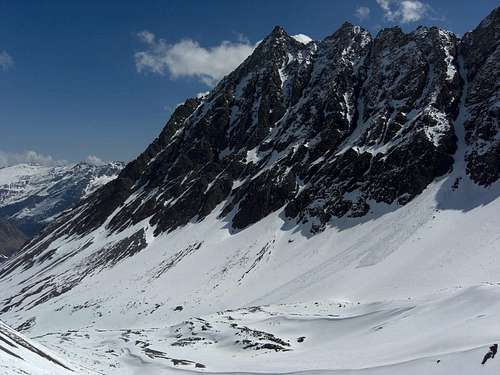
Lisenser Fernerkogel is the northernmost peak of a south - north - running ridge, starting from Schrankogel and Schrandele, two impressive main summits of the Stubai Alps. This ridge splits up at Hinterer Brunnenkogel to form a huge V which embraces the impressive and large Lisenser Ferner, a plateau glacier which starts now at about 2950 m hight and - as you can learn from the glacier information trail of Lisens, had its recent largest expansion in the year 1890, reaching the valley floor at the location Fernerboden, 1716 m high, south of Lisens.
 Ski slopes below glacier Ski slopes below glacier |  Overcoming the lower slab zone Overcoming the lower slab zone |  The slopes of the Mauer The slopes of the Mauer |
Nowadays this slope of 1.200 meters of altitude difference is completely ice free and builds the impressive “Mauer” (“the Wall”) leading up from Lisens to the glacier. This “Wall” is flanked to the east by Hohe Villerspitze and Rinnenspitze and to the west by the huge rockfaces of Lisenser Fernerkogel and Rotgratspitze.
So, showing steep and high rockfaces to the east, north and west, you may wonder how to get on the summit. The normal route uses the Lisenser glacier and the south arete to reach the top.
Winter or spring ski hike or summer glacier route, Lisenser Fernerkogel is nearly an all season mountain and worth the effort (1.700 meters of altitude difference from Lisens).
Getting There
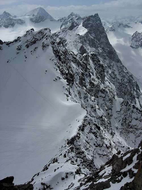 Hinterer Brunnenkogel and Rotgratspitze from summit arete
Trailheads for Lisenser Fernerkogel are:
Lisens
From Munich
From Kufstein, Innsbruck or Landeck
Franz Senn Hütte
From Innsbruck
Railroad service for Stubaital ends at Fulpmes, north of Neustift. See the Austrian Railway schedule here.
For Lisens leave the railroad at Zirl / Kematen and go on with local public busses .
The nearest airport is Innsbruck - Kranebitten.
Normal Routes Overview
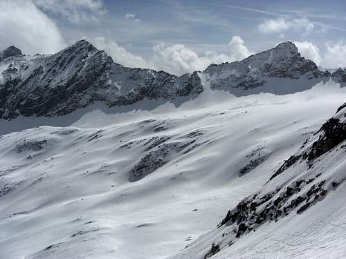
 Ski route overview - slab zone
Lisenser Fernerkogel is an all season summit.
Ski ascent
The ski ascent starts at Lisens. Follow the valley to Fernerboden at the end of the valley. Bear left to overcome the lower and the upper rock and slab zone (difficult part in case of ice or with low snow) and continue up the slope, first to the left, then to the upper right to reach the glacier rim. Enter the glacier at its northwestern rim and do a huge U-turn, first heading west then turning east and climbing the steep slope up to Plattige Wand.
At the notch of Plattige Wand turn west again and ascent north of Rotgratspitze on the rests of Rotgrat glacier to the notch between Lisenser Fernerkogel and Rotgratspitze. Leave your skies and ascent the easy south arete (UIAA grade I) to the summit.
Alternatively enter the second (southern) chute which comes down from the rests of Rotgrat glacier and ascent the chute up to the glacier. Go on as above.
Both ascents can be used for downhill. The chute is more exposed to avalanches. The ascent via Lisenser Ferner is, in my opinion, the more spectacular, though slightly longer.
 Ascent to Rinnennieder Ascent to Rinnennieder |  Upper south arete and summit Upper south arete and summit |  South arete and summit from below ski depot South arete and summit from below ski depot |
Summer ascents
The ski route from Lisens is the summer ascent, too. There is a trail leading up to Lisenser glacier which is located east of the ski track below the secondary summits of Blechnerkamp and Kreuzkamp.
Don´t use the chute in summer, the glacier ascent is by far the more interesting route.
From Franz Senn Hütte follow the trail up to Rinnensee and Rinnennieder, a notch south of Rinnenspitze. Descent steeply on the Lisenser glacier, traverse the glacier to the west until you reach the ascent route from Lisens. Go on as described above
 Huge Lisenser glacier from Plattige Wand Huge Lisenser glacier from Plattige Wand |  Hinterer Brunnenkogel and Längentaler Weissen Kogel from summit arete Hinterer Brunnenkogel and Längentaler Weissen Kogel from summit arete |  The ski route chute The ski route chute |
Red Tape & Accommodation
 Franz Senn Hütte
Red Tape
There are no special restrictions in this area as far as I know.
Accommodation
You will find all kinds of accommodation in the following villages:
The following mountain huts are around Lisenser Fernerkogel:
Franz Senn Hütte (as trailhead for the summer normal route) Excellent homepage with tons of useful and actual information
Westfalenhaus (northwest of the summit in Längental)
Gear & Mountain Condition
 Rotgratspitze as seen from ski ascent
Lisenser Fernerkogel is an all season summit.
In winter and spring it is a classic ski tour which requires full ski tour gear and ski crampons; an ice axe and crampons can be useful to overcome the lower slab parts of the “Mauer” and the south arete, with icy conditions.
Full avalanche gear is required.
Check the Tirol avalanche bulletin here.
As for the glaciers, I´ve never seen somebody roped and with harness in winter / spring.
In summer you need full mountain equipment and additional glacier gear with rope, harness, ice axe and crampons for the glacier traverse.
The summit arate can be rated UIAA grade I in parts - it is an easy rock scramble but very exposed.
Check the weather forecast here or here.
Maps & Guide Books
 Rinnenspitze as seen from ski ascent
Maps
Alpenvereinskarte 1 : 25.000
Blatt 31/2, Stubaier Alpen / Sellrain
Deutscher Alpenverein 2009
Österreichische Karte 1 : 50.000 UMT
Blatt 2228, Neustift im Stubai
Bundesamt für Eich- und Vermessungswesen, Wien, 2005
Österreichische Karte 1 : 50.000 BNM
Blatt 146, Ötz, 1998
Blatt 147, Axams, 1997
Bundesamt für Eich- und Vermessungswesen, Wien
Guide Books
Alpenvereinsführer
Stubaier Alpen, alpin
Bergverlag Rudolf Rother, München, 2006
Rother Skitourenführer
Sellrain / Küthai
Bergverlag Rudolf Rother, München, 2007