
|
|
Mountain/Rock |
|---|---|
|
|
47.05440°N / 11.11120°E |
|
|
11131 ft / 3393 m |
|
|
Overview
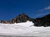
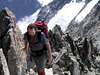
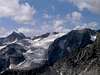
The 8th highest mountain in the Stubai mountain range. It is a mountain with no easy ascent, the easiest one (normal route) is UIAA grade I. All ascents are partly glacial routes. To my feeling it is only seldomly climbed.
 |  |  |
Getting There
The mountain is usually approached from either the Amberger Hütte or the Franz-Senn-Hütte.
Via the Amberger Hütte:
Start in the Sulztal (goes from the Ötztal) to the Amberger Hütte (2 h). From there towards the Schwarzenbergferner. Via the south ridge towarts the summit.
Via the Franz-Senn-Hütte:
Start in the Oberbergtal (goes from the Stubaital) to the Franz-Senn-Hütte (1 h). From there towards the Alpeiner Ferner over the Wildgratscharte to the Schwarzenbergferner. Then as described above.
The normal route (UIAA grade I) is not marked (1 h) and goes along the south ridge.
Further routes are the east ridge (II) and the north ridge (III) - both from the Franz-Senn-Hütte.
When To Climb
Summer: June - October
Winter: March - April (Ski ascent - please note: skis can be used usually only for the approach - scrambling is essential)
Guides and Maps
The recommended guide is the "Alpenvereinsführer" "Stubaier Alpen" by Walter Klier (Bergverlag Rother, 2002)
ISBN: 3-7633-1271-4 (Description)
A detailed map is available from the Alpenverein (Stubaier Alpen - Hochstubai - 31/1 1: 25000)
This map is available with or without routes for ski mountaineering (Description).
A good map is sold by freytag & berndt (Innsbruck, Stubai - Seelrain, Brenner 1:50000, WK241).
(Description)
Huts in the Vicinity
General Information on huts is given in Jo's Hüttenliste
Amberger Hütte: 2135 m, Tel.: +(A) 05253 / 5605 (open end of Feb. - 15. May and beginn of July - 15. Sept.)
They have a homepage: Amberger Hütte
Franz-Senn-Hütte: 2147 m, Tel.: +(A) 05226 / 2500 and 05226 / 2218 (Mid Feb. - Mid May and Mid June - Beginning of October)
They have a homepage: Franz-Senn-Hütte
Mountain Conditions
Mountain conditions are available from the huts in the vicinity.
Winter climbing: Propability of avalanges can been found here: Lawinenwarndienst - Österreich
Information of alpine weather is found here: Wetter
Red Tape
No fees, no closures.
Camping
The whole area is a "Naturschutzgebiet " (similar to a national park) which prohibits camping, possibly bivouaking is allowed (at least tolerated). Sleeping is of course possible in the surrounding huts.
Camping is possible in Volderau (some kilometers from Neustift in the Stubaital)and in the Ötztal in Längenfeld (30 km from Vent) (Homepage)
Further camping sites might be in Sölden (15 km from Vent) and Huben (20 km from Vent) in the Ötztal.
tuan walter - Apr 17, 2006 2:57 pm - Voted 8/10
Stein & Schnee - Datenbank für alpinistische RoutenDescription of the normal route (south ridge) - in German + photos