
-
 29584 Hits
-
 88.61% Score
-
 27 Votes
|
|
Canyon |
|---|---|
|
|
40.57310°N / 111.7761°W |
|
|
Hiking, Mountaineering, Trad Climbing, Sport Climbing, Toprope, Bouldering, Ice Climbing, Aid Climbing, Scrambling, Skiing |
|
|
Spring, Summer, Fall, Winter |
|
|
Overview
Little Cottonwood Canyon is one of the three large canyons that carves dramatically through the +11,000 ft high Wasatch Mountains, dropping some 3,000 ft to the Wasatch Front Metropolitan area. Collectively these three canyons are known as the tri-canyon areas (Millcreek Canyon, Big Cottonwood Canyon, & Little Cottonwood Canyon), with the Cottonwood Canyons being popular for a multitude of activities such as cycling, hiking, snowshoeing, picnicking, backcountry skiing, fishing, mountaineering, and ice and rock climbing. Snowbird and Alta ski resorts, which often receive around 500 inches of dry powdery snow each season, are also located at the top of the canyon and are accessible via public transit. During the summer months you can enjoy a tram ride, festivals, and music concerts at Snowbird. The backcountry skiing areas here are world renown (especially in the Lone Peak and Broads Fork Wilderness Areas), although Powderbird’s helicopter skiing services have been an issue of contention among skiers, the ski industry, and environmentalists.
During the mid-1800s, miners sought their fortune in gold and silver in this canyon, and remnants of the old mines can still be found in the upper parts of canyon, especially around the Albion Basin Area above Alta. In fact, the town of Alta started as a mining boomtown, and was often ravaged by avalanches coming off of the Wasatch peaks, which occasionally destroyed the entire town. In its mining heyday, Alta was a violent town, considered by the Mormons in the Salt Lake Valley to be riddled in sin. Although, I’m not certain if this is entirely correct, I remember hearing that Hell Gate Cliffs, which are passed just before reaching Alta, were named as such because the cliffs marked the gateway to hell (i.e. Alta). During WWII Alta was a premier training ground for the 10th Mountain Division, which later served the US in military combat in Europe’s more extreme mountain environments. After the war, Alta became an important testing ground for studying avalanches, and many contributions to the forecasting and control work of avalanches came from here.
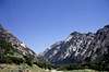
Ancient glaciers carved the spectacular vistas of the 8-mile long canyon, which is obvious upon seeing the huge U-shape of the canyon. The tributary gulches to the south were also glacially carved, leaving many rugged mountain cirques, although the main canyon was carved in such a way that most of these gulches are very inaccessible from the main canyon, and must be approached by climbing over mountain passes. It enjoys a prime location near the Great Salt Lake and the southern end of the Salt Lake Valley, bounded by smaller foothills. The combination of lake effect and the directing shape of the southern end of the Salt Lake Valley funnels much of Utah’s winter storms directly up Little Cottonwood Canyon, which is why the resorts here usually see much more snow than Utah’s other ski resorts. The canyon is also one of the most avalanche prone canyons in North America, as is evident by the many avalanche slide area signs passed while driving up the canyon. There are some 30 avalanche paths that can reach the highway, and over 300 known major slide paths in the entire canyon complex. Because of this, during big winter snowstorms, UDOT often cannot keep the road safe, and it is occasionally closed until proper avalanche control can be completed (often stranding skiers up the canyon!).
Although this canyon is only a few miles south of Big Cottonwood Canyon, the rock here is completely different. Friction face climbing and crack climbing predominate here on coarse and polished granite. As such, the routes often rise at a kinder angle, although in general the climbing here is more difficult. There aren’t as many opportunities to top-rope here, as most of the climbing routes are multi-pitch. The valley bottom has open forests with many granite boulders that are popular for bouldering, especially during the midday summer head.
Higher up the canyon there are climbing areas on limestone on Hell Gate Cliffs and Devil’s Castle. There are also a number of alpine routes up Hogum Fork, and on White Baldy and the Pfeifferhorn, although the granite at the higher elevations has weathered in such a way that it is fairly loose and broken, especially when compared to the large expanses of unbroken granite lower down in the canyon. In the winter these gulches are premier areas for ski mountaineering, and many extreme routes can be found in the couloirs and bowls here. Some examples are the South Face of Mt Superior, The Pfeifferhorn’s North Ridge and NW Couloir, N Thunder Mountn’s Y-Couloir, and Lone Peak’s east face.
The majority of climbing areas are found within the first two miles on the north side of the Canyon. The Church of Jesus Christ of Latter-Day Saints (LDS) owns property all along the road at the base of the cliffs, and No Trespassing signs are posted. However, Ted Wilson and Rick Reese, representing the climbing community, have brokered a compromise with the LDS Church allowing climbers to cross this property to reach the crags. Please respect the fact that this is private property, and do your part to minimize the climber’s impact on the area. The Wasatch Resort on the south side of the road also makes access difficult to the routes on the south side of the canyon, but no official compromise has yet been made with the resort for approach access.
While there are many possible routes in the canyon, most of the routes listed in guidebooks are within a 15-minute hike from the road. Due to the laziness of local craggers, there are many unrecorded and unclimbed routes on the cliffs higher up the steep canyon walls.
On days off, there is a shaded old dirt road ascending the bottom of the canyon that is popular for hiking, jogging, and mountain biking. It can also be used for some approaches on the south side of the canyon.
One final note is the ice climbing in the canyon. The areas around Scruffy Band at the mouth of the canyon often offer intermediate to advanced ice climbing conditions. Near Coalpit Gulch, the Great White Icicle offers a great 5-pitch WI 3 route that is almost always ‘in’, and it is one of the most popular ice climbing routes in the Wasatch. In the summer the waterfall that forms this climb is also descended as a 3C II canyoneering route. In the winter the sun often melts off the granite on the north slopes, so climbing can often be found here year-round. In fact, it’s entirely possible to go rock climbing, ice climbing, and skiing here all in the same day!
 |  |  |  |  |
Getting There
By Car:Little Cottonwood Canyon is located at the intersection of Highway 210 and S Little Cottonwood Canyon Rd about miles southeast of downtown Salt Lake City, Utah.
Unless you're coming from Sandy, the most common way to get to Little Cottonwood Canyon is to get on the I-215 WB Belt Loop and follow the signs for the Cottonwood Canyons Ski resorts.
At Knudsons Corner, take the 6200 S exit- EXIT 6- toward SKI AREAS/Solitude / Brighton/Snowbird / Alta for 0.2 miles. Merge onto UT-190 E toward SKI AREAS/Solitude / Brighton/Snowbird / Alta and drive for 1.8 miles to the mouth of Big Cottonwood Canyon, which is at Fort Union Blvd & Wasatch Blvd. Continue straight through the stoplight and follow the road another 4 miles to the mouth of Little Cottonwood Canyon, where an electronic billboard on the right provides current road and/or weather conditions.
At the mouth of the canyon is a Park'N Ride. This is a popular place for recreationists to meet up & carpool up the canyon or begin bike rides up the canyon. In the winter, this is the hub for the ski buses, that run from the city up to the Ski Resorts. At the Park'N Ride you are treated to a wonderful view of the mouth of Little Cottonwood Canyon, with some of the crags right above the parking lot, and some dramatic granite ribs and ice-covered cliffs (in winter) on the other side. There is even a telescope by the bus stop for viewing mountain goats that frequent the area.
By Bus:
The mouth of the canyon can be accessed by UTA mass transit. In the winter, you can get on a ski bus to go up to the ski resorts, although to get to the crags, you'll either need a friend with a car or bring a bike (most of the climbing is a short bike ride up the canyon). Depending on where you're starting, you can get there using a combination of bus and TRAX, the metro area's light rail. UTA's website has a good Trip Planner for figuring out your schedule.
 |  |  |  |
Climbing Areas Overview
From the Park N’Ride you can already see numerous climbing routes in the canyon – a myriad of large bolders and outcroppings high up on the north slopes, and a series of large ribs and slabs lining the south side of the canyon. As you drive up the canyon, most of the climbing is found on the north slopes on your left, as is evident by the many cars usually filling the pullouts and shoulders along this area. Some areas of note along here are the Thumb, which is obvious from the road, and Gate and Black Peeler Buttresses. On the right high up the canyon is a huge ridge with a daunting east face – this is Perla’s Ridge. At the Power Plant pullout most of the climbing is found on the south side of the canyon near Coalpit Gulch in areas such as Penta Pitch and the Great White Icicle. Beyond this, climbing potential withers, with Lisa Falls being one of the higher popular spots. Next there are some routes up Tanners Gulch on the north side of the Canyon, the Tanners Flat TH which is used for approaches to alpine climbs on Thunder Mtn, The Pfeifferhorn, and White Baldy. Finally, the granite is replaced with limestone, and good climbing areas re-appear along the road as you pass Hell Gate Cliffs on the north side of the canyon. At the end of the paved road, Albion basin has a smattering of climbing areas, with Devil’s Castle obviously containing a few alpine routes.The climbing areas are described in the order in which they are reached, heading up the canyon. Only those sections listed under the ‘routes’ section are covered here – there are still many more areas to climb!
Lisa Falls:
Lisa Falls is found 2.8 miles up the canyon at the mouth of a steep gorge that empties off of the Broads Fork Twin Peaks, on the north side of the road. It is a short ways up a trail, and offers many routes for top-roping and leading on granite slabs with a waterfall pouring through. If you follow the stream up, you can eventually reach the summit of the Broads Fork Twin Peaks via routes such as Lisa Falls Direct. Friction face climbing predominates here.
Summits Overview
The following are a list of summits than can be climbed from directly from Little Cottonwood Canyon or one of its tributaries, listed in order of the trailheads reached.- North Thunder Mtn – 11,150 ft
- South Thunder Mtn – 11,154 ft
- Chipman Pk – 10,954 ft
- Broads Fork Twin Peaks – 11,330 ft
- Sunrise Pk – 11,275 ft
- Mt Dromedary – 11,107 ft
- Pfeifferhorn – 11,326 ft
- White Baldy – 11,321 ft
- Red Baldy – 11,171 ft
- American Fork Twin Peaks – 11,489 ft
- Mt Baldy – 11,068 ft
- Mt Superior & Monte Cristo – 11,132 ft
- Flagstaff Mtn – 10,530 ft
- Honeycomb Cliffs – 10,480 ft
- Mt Wolverine & Tuscarora – 10,795 ft
- Sunset Pk – 10,648 ft
- Devil’s Castle – 10,920 ft
- Sugarloaf Pk – 11,051 ft
If there are peaks that need to be added or are in improper order, please let me know!
Page and Route Format
Since there are so many short climbs in this canyon, I've grouped them together by the main rock feature ascended. In some cases I've grouped several features onto one route. The routes begin with a listing of all climbs in the area, their difficulty, quality (out of 3 stars), and FA. Route overview information is used from Stuart & Bret Ruckman's Rock Climbing the Wasatch Range to give people a general idea of what's out there. Alterations to climbing quality ratings, and in depth route descriptions are included only for the routes I've climbed (sorry, but if you want the info for the other routes, you'd better get the guidebook!)Many of the climbing areas are still not listed on the page - I'm only putting them up after I've climbed at least one route in the area.
If you've done a climb in the areas listed as routes, feel free to add info for an existing climb or for an unclimbed route, and I'll integrate it into the page. If you've climbed in a region not listed, feel free to put up a route page for it, but please try to stick with the general format for this page to maintain continuity.
Red Tape
Little Cottonwood Canyon is part of the Salt Lake City Watershed. As a result no dogs are allowed. Many of the side canyons are in the Lone Peak and Broads Fork Twins Wilderness Areas. Regulations for these wilderness areas are as follows:- Camp at least 100 ft from the trail and 200 ft from any water source
- Do not defecate or urinate within 200 ft of any water source
- Do not swim in any of the reservoirs
- No dogs or horses
- Parties limited to 9 people
Apart from these restrictions, no permits are needed to enter or camp in the wilderness areas.
Many of the climbs are on private property or cross private property to access them. Please be respectful of the owners and the land you are accessing.
When To Climb
Usually the rock routes are in prime climbing conditions beginning in April and lasting until late October. During Salt Lake's regular warm thaws throughout the winter, the lower routes often melt out enough to allow climbing in the middle of the winter! During the winter the Scruffy Band and some of the other cliffs on the north-facing slopes accumulate enough ice for some good water ice climbing. The most popular route, which is almost always ‘in’, is the Great White Icicle, which is near Coalpit Gulch and the Pentapitch Area.In the summer the routes on the large south-facing granite slabs get very bright and very hot – be careful about getting caught on a multi-pitch climb there in the middle of summer, when temperatures can exceed 100oF and there’s no shade in sight! Getting your toes burned from heated climbing shoe soles is not very fun
Mountain Conditions
- For the 7-day forecast, click here
Camping
Free camping can be had if you hike into the neighboring wilderness areas. For more accessible camping, Little Cottonwood Canyon has 2 Campgrounds, which are part of the Salt Lake Ranger District:None of these campgrounds are open in the winter.
Nearby Amenities
Emergency ServicesDiall 911 from any phone. There are public phones located at the Park'N Ride at the mouth of Little Cottonwood Canyon
- Alta View Hospital - 9660 S 1300 E – (801) 567-2600
- Alta Canyon Sports Center - 9565 S Highland Drive (corner of 9400 S & Highland) – (801) 942-2582
Showers cost $3.20 and their hours are M-F 6am-10pm, Sat 7am-8pm, Sun 12-5pm.
There is a gas station and ATM at the mouth of Big Cottonwood canyon. Driving south on Wasatch Blvd from this intersection will bring you to another stoplight. A Smith's grocery store is one block west (right) of here on 7800 S. If you head west on Highway 209 from Wasatch Blvd (S Little Cottonwood Canyon Rd turns into this), there will eventually be a gas station and a grocery store with an ATM on your right.Local Equipment Retailors
- Black Diamond - 2084 E 3900 S, SLC - (801) 278-0223
- IME - 3265 E 3300 S, SLC - (801) 484-8073
- REI - 3285 E 3300 S, SLC - (801) 486-2100
- Wasatch Touring - 702 E 100 S, SLC - (801) 359-9361
- Exum Utah Mountain Adventures - Black Diamond Center, 2092 E 3900 S, Suite B, SLC - (801) 272-7338
- Rockreation - 2074 E 3900 S, SLC - (801) 278-7473
- Wasatch Front Climbing Gym 427 W Universal Circle (9160 S), Sandy - (801) 565-3657
Of course you can find plenty of good places to eat in the city or at the ski resorts, but these are a few of my favorites:
- Salt Lake Roasting Co. - 320 E 400 S - (801) 363-7572
- Einstein Bagels - 3900 S & Wasatch Blvd.
- Cottonbottom (pub, garlic burgers) - 2820 E 6200 S - (801) 273-9830
- Hoppers Grill and Brewing Co. - 7145 S (Corner of Ft Union Blvd) 900 E - (801) 566-0424
- Brewvies - 677 S 200 W - (801) 355-5500
There are two hostels frequented by climbers and skiiers, but neither one is close to the crags.
- Avenues Hostel - 107 N "F" Street - (801) 359-4525
- Ute Hostel - 21 E (between State & Main) 1160 S - (801) 595-1645
External Links
- Outdoors in Utah
A touristy site that gives a nice overview of the canyon.
- Rock Climbing.com
A page similar to summitpost with a lot of firsthand information of various climbing routes in the state.
- Climbing Salt Lake
A page similar to summitpost, covering different climbing routes in the Salt Lake metro area. It is also a good place to meet climbing partners, even if you're just visiting SLC.
- Ice Climbing - Little Cottonwood Canyon
A page on ice climbing in Little Cottonwood Canyon, more specifically covering the Great White Icicle.
toddkutzke - Mar 4, 2015 9:17 am - Hasn't voted
New Little Cottonwood GuidebookLocal Tony Calderone has published a new Little Cottonwood Rock Climbing digital guidebook for iOS and Android devices that works beyond the reach of cell service.. Tony's guidebook contains well over 1000 routes in addition to car to crag navigation. Tony has been active in the Little Cottonwood climbing community for well over 20 years, putting up many first ascents and replacing over 1000 manky 1/4 inch bolts with new safe hardware.