
-
 24366 Hits
-
 81.84% Score
-
 14 Votes
|
|
Area/Range |
|---|---|
|
|
Hiking |
|
|
11489 ft / 3502 m |
|
|
Overview
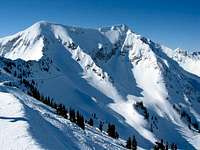
The Wasatach's Alpine Ridge is the name given to the east-west ridge of peaks which forms the southern side of Little Cottonwood Canyon. The western end of the ridge is anchored by Lone Peak, one of the monarchs of the Wasatch front range peaks, while the east end of the ridge terminates at the rugged summit of Devil's Castle.The Peaks
Moving from West to East, the major peaks along the Alpine Ridge are as follows:
Lone Peak - (11,253 feet)
Although not the highest peak on the Alpine Ridge, Lone Peak is considered by some to be one of the monarchs of the Wasatch range. The peak presents a commanding presence at the south end of Salt Lake valley. One of the more difficult hikes in the Wasatch, virtually all routes to the summit involve significant elevation gain and/or distance. The vertical walls of the cirque forming the summit block also contain many rock climbing routes.

Bighorn Peak - (10,877 feet)
Also known as Upper Bells Peak. Somewhat overshadowed and largely ignored due to its proximity to nearby Lone Peak, this peak is seldomly climbed. All routes require significant elevation gain, particularly those originating from the Bells Canyon side. Climbed infrequently due to long approaches and significant elevation gain.
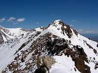
South Thunder Mountain - (11,154 feet)
The high point at the southern end of the ridge between Hogum Gulch on the east and Thunder Bowl on the west. The summit provides an excellent view of the east face of Lone Peak, as well as a good view down into Bells Canyon. On the summit is a mailbox containing the summit register.
North Thunder Mountain - (11,151 feet)
The lower (by 3 feet) of the Thunder Mountain twin summits, which lies approximately 1 mile to the north of South Thunder. The two peaks are connected by the long rugged ridge which forms the west wall of Hogum Gulch. With difficult approaches and a minimum of 5000+ vertical feet of elevation gain, this is probably one of the least frequently visited summits in the Wasatch. A mailbox and register are located on the summit.

Chipman Peak - (10,954 feet)
Chipman Peak lies on a short spur ridge to the southeast of South Thunder Mountain. Although technically not a peak as defined by the 300-foot rule, this summit has aquired what is apparently the local name of Chipman, and is commonly referred to as such. The peak is probably climbed most frequently as part of the Beatout route, but even so, it probably sees very few visitors relative to the nearby higher summits. The peak also has the distinction of being the only summit with a view of nearby Lake Hardy.

Peak 11,137 - (11,137 feet)
The unnamed high point to the west of the Pfeifferhorn. This point fails to qualify for official "peak" status, per the 300-foot rule, but it still offers a fairly commanding presence on the ridge between the Pfeifferhorn and Chipman Peak. Seldomly visited, with the exception of those completing the Beatout route.
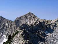
Pfeifferhorn - (11,326 feet)
Arguably one of the most popular summits in the Wasatch, this peak is climbed very frequently, both in summer and winter. The distinctively shaped summit knob sits at the southern end of the ridge dividing Hogum Gulch on the west and Maybird Gulch on the east. Most commonly climbed via Red Pine Lake, the peak also offers several technical mountaineering routes on the north and west.

White Baldy - (11,321 feet)
Although just five feet lower in elevation than the nearby Pfeifferhorn, White Baldy sees far few visitors, despite sharing a major portion of the primary approach trail. Somewhat more difficult to climb than the Pfeifferhorn, the peak offers much greater solitude, and a rather unique view of the divide between the Red and White Pine drainages. The summit is a fairly long and flat ridge, with the high point at the far east end.
Red Baldy - (11,171 feet)
Another infrequently climbed peak which is accessed most easily from White Pine Canyon. The summit is a long and relatively flat ridge, with a false summit towards the west; the true summit lies several hundred yards further to the east.

Red Top - (11,370 feet)
Also referred to as "Red Stack" and "Haystack", this high point also fails to qualify for "peak" status by virtue of the 300-foot rule. When viewed from the upper White Pine Basin, Red Top appears to have a relatively commanding apperance, but other perspectives (particularly from the north) quickly reveal it is little more than a small rise on the west ridge of American Fork Twins.
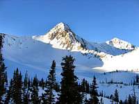
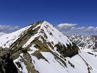
American Fork Twin Peaks - (11,489 feet)
Overlooking Snowbird Ski Resort's Gad Valley, American Fork Twins is the highest point on the Alpine Ridge, and is also the Salt Lake County highpoint. At 11,489 feet the west twin is slightly higher than the 11,433-foot east twin. A third "twin" of 11,391 feet lies to the south, and may be climbed by an easy ridge traverse from the east twin.
Hidden Peak - (10,992 feet)
Hidden Peak is notable primarily for being the dump-off point of the Snowbird Ski Resort Tram. The tram provides easy access to a peak for those unable or unwilling to climb one on their own, but the summit experience also comes with large crowds, a pay phone, and a bathroom with running water.
Mount Baldy - (11,068 feet)
Mount Baldy lies on the divide between Snowbird and Alta ski resorts, and is an easy climb from either resort. The peak lies on the ridge to the east of Hidden Peak, which is the top of the Snowbird Tram.
Sugarloaf Peak - (11,051 feet)
A gently rounded summit and high trailhead elevation results in Sugarloaf Peak being most likely the easiest of the Wasatch "11'ers" to climb. The Peak forms the prominent backdrop to Cecret Lake, which is where most climbs of Sugarloaf typically pass by.

Devil's Castle - (10,920 feet)
The last major summit at the eastern-most end of the Alpine Ridge, Devil's Castle consists of a rugged black ridge capped by a series of rocky spires. The castle-like appearance of the peak is most apparent when viewed from points along the ridge to the east of the summit. The peak overlooks the Albion Basin of Alta Ski Resort, and is often photographed as a backdrop to the numerous wildflowers for which the basin is well known.
dillweed - May 7, 2006 9:46 am - Hasn't voted
would you please add my page?Hi Joseph, I am fairly new to SP, but I love it, and I have created a page for Hidden Peak (almost all of the peaks around here are already done - so I had to settle for a less "sexy" peak), and I wondered if you would add Hidden Peak to this page - I want the page to get some exposure, even though the peak isn't that exciting. It does have some interesting history/current events that no other peak in Utah can claim. thanks for considering it. Emerson (dillweed) p.s. maybe I could hike Grandeur Peak with you sometime - if I could keep up with you.
Joseph Bullough - May 8, 2006 1:52 pm - Hasn't voted
consider it...... done!
dillweed - May 8, 2006 7:13 pm - Hasn't voted
thanksthanks