
-
 4519 Hits
-
 73.06% Score
-
 3 Votes
|
|
Area/Range |
|---|---|
|
|
37.64359°N / 22.27974°E |
|
|
Hiking, Mountaineering, Skiing |
|
|
Spring, Summer, Fall, Winter |
|
|
6499 ft / 1981 m |
|
|
Overview
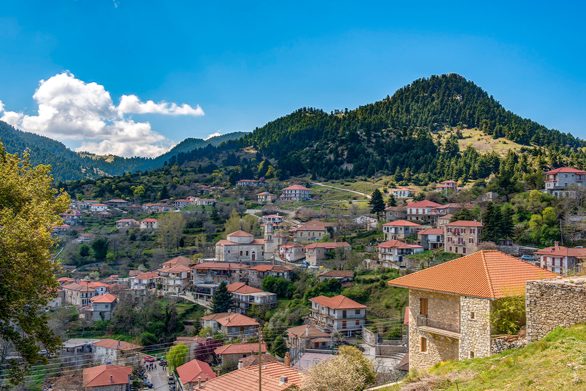
Mainalon (“Μαίναλο”) mountain range is one of the most sprawling and storied ones in Greece, it is located in the center of the Peloponnese and falls under the jurisdiction of Arkadia. It is home to 50 peaks over 1,200m, several rivers, waterfalls, and gorges, alongside a quaint ski center and some of the most storied villages in the country. The range can be divided into East and West by the valley of Alonistaina (“Αλωνίσταινα”), which goes from Vytina (“Βυτίνα”) to the North all the way to Chrysovitsi (“Χρυσοβιτσι”) to the South. The highest peak is Ostrakina (1,981m) located East of the ski center at the East side of the massif above the village of Kardaras (“Καρδαρας”).

Mainalo is currently a protected part of the Natura 2000 network. It is known for its lush forests which until the fires of 2011 were mainly covered by fir towards the North, while the South is mainly covered by pine and cypress. The core area of Ostrakina, towards the ski resort, including the plateau is still home to a lush forest of assorted conifers. The Natura 2000 area of “Oros Mainalo” was established in 1996 and protects 3 species, 2 reptiles and 1 invertebrate. It is home to the near threatened “Hermann's Mediterranean Tortoise”. Finally, the villages of Alonistaina (1,220m), Elati (1,200m), and Magouliana (1,365m) are some of the highest in the country; no wonder that the area is home to a number of Sanatoriums from the early 20th century.
History & Area Guide
|

|
|
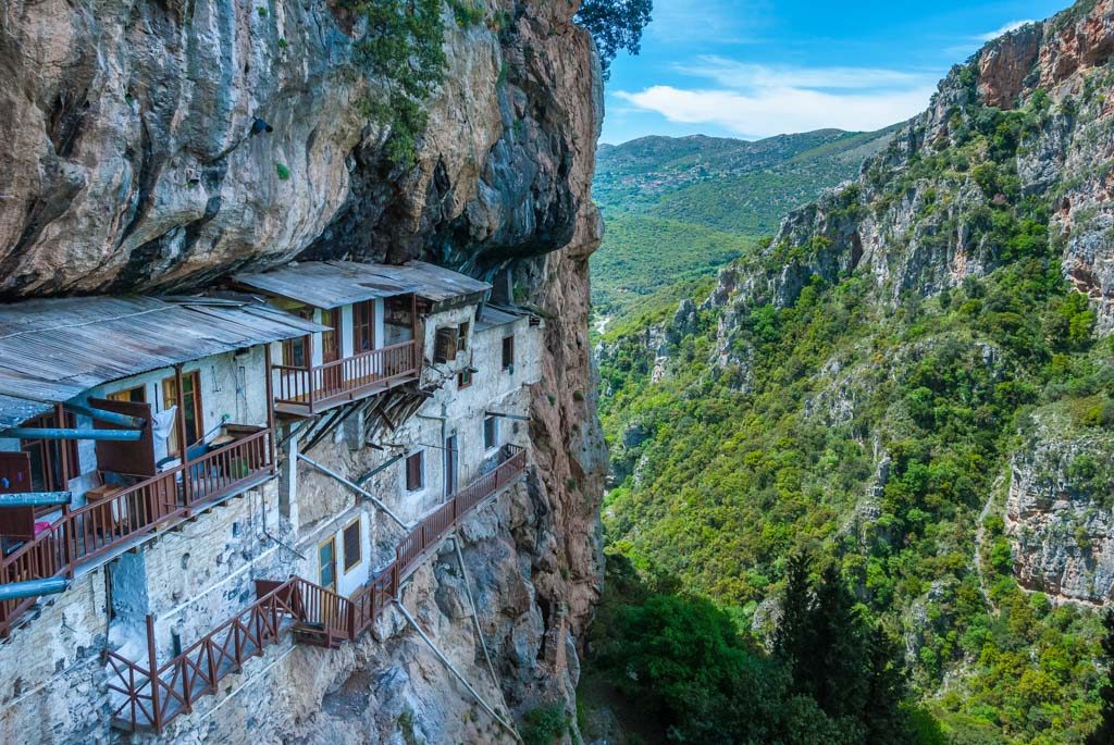
According to legend the mountain takes its name from Maenalus son of Lykaion, King of Arcadia, who ruled from Mt. Lykaion. The Arcadians who lived in the area during the early Hellenistic period believed in the god “Pan” (“Παν”) – the god of shepherds and the wild – and this deity would later be worshiped across the Hellenic world. Important during the ancient period was the village of Stemnitsa (“Στεμνίτσα”). The area continued to be inhabited, with a monastic community growing in the gorge of Lousios river (“Λουσιος”) during the medieval period. In the 17th century European explorers who utilized the works of Pausanias to travel into the Peloponnese would call the entire mountain range “Mainalo” after the author, who had however, described a single mountain top near the city of Tripolis (“Τριπολη”), which in 2011 was confirmed as Agio-Lias (1,117m) [“Αγιο-Λιάς”], a site which houses the ruins of a temple from the 1st century BC.
The area would become a center for the national struggle for independence during the Greek War of Independence (c. 1821) during which many of the men of the villages of Mainalo went on to fight. Many of them saw success, and some of the most well-known come from here. For example, Kolokotronis ("Κολοκοτρώνης") was raised in the village of Piana (“Πιανα”) where visitors can see his home, nestled within the protected area of Arkoudorema. Today many of these villages remain very popular with Greek tourists especially in weekends during Fall and Spring. Vytina is the largest town in the area with Stemnitsa, Alonistaina and Dimitsana also being popular.
The Mountain Range
The Mainalo East Massif
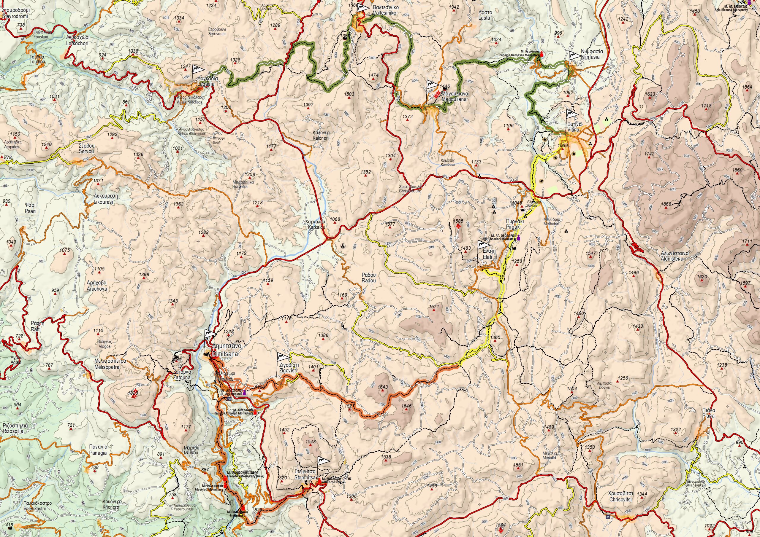
The East massif is the most important part of the range. It hosts every single one of the alpine summits as well as the Mainalo Ski Center. The East massif is bordered by the Villages of Vytina and Alonistaina on the West and the Tripoli plateau on the East. This massif is marked by two important alpine formations, Ostrakina Massif, and the peak of Aintinis (1,849m); these two formations are connected to each other through the Mourtzia (1,761m) ridge. The massif is very steep and features tight packed glades in elevations up to 1,900m, with few summits being completely void of trees. In the map you can clearly see many peaks of the massif as well as other important points of interest. The two main hiking centers are the Ostrakina Plateau, where the ski resort is located, and the village of Roeino (“Ροεινο”). It may be possible to hike from Roeino to the plateau via Mourtzia ridge, it would however require staying on the mountain overnight.
There are many different trails throughout the Eastern massif, the main trails connect some of the villages in the range. These trails are not dense and create more of a net than a circuit; the higher you go the less trails there are. This being said the southern peaks of the range only feature one access point; this is also the case with Ostrakina (1,981m) where there are only two trails that lead up to the summit via the plateau. The Eastern massif offers interesting opportunities for hiking and skiing in mildly steep and exposed terrain on the transition between forest and alpine.
The Mainalo West Massif
The West massif is a large "sea" of lower peaks that most closely resemble rolling hills; these peaks are low prominence and under the tree line. This area is much larger, from Vytina to Megalopoli to the South and Dimitsana to the West. There is sadly not much information on the peaks but what seems to be the highest point is the “Pleiovouni” (1,643m) just above the village of Zigovitsi. There are many other peaks between 1,500m-1,600m of elevation. Notable summit is also that of "Madara" (1,585m) which is home to the Madara fire-lookout on its imposing ridge, situated above the vilage of Elati. The good thing is that there are many trails, the Mainalon trail long distance trail runs through almost the entire range with so many side trails and access roads. Finally, the section on the North by the village of Magouliana has two named and prominent peaks Psilo Vouno (1,503m) and Alogovouni (1,474m), underneath them is located a former sanatorium now converted into a hotel.
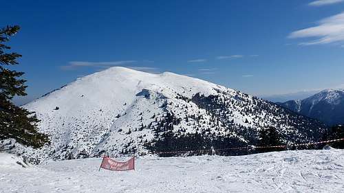
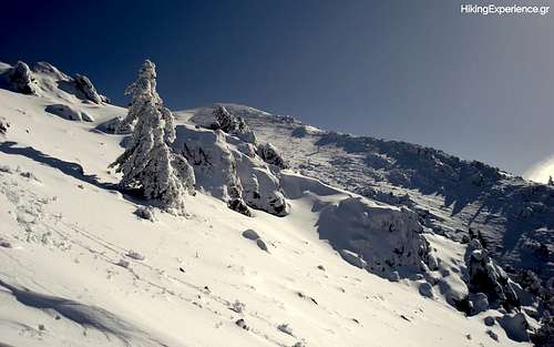
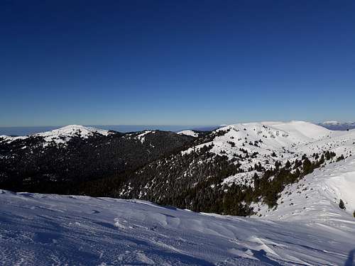
Photos of the Range
|
|
|
|
|

|
List of Highest Peaks
| Name | Elevation | Coordinates | Main Trailhead | Area |
| Ostrakina | 1,981m | 37°38'37.7"N - 22°16'47.0"E | Ostrakina Refuge | East |
| Sfentami | 1,870m | 37°38'40.7"N - 22°15'37.1"E | Ski center parking or top | East |
| Tzelati | 1,868m | 37°38'50.0"N - 22°13'23.2"E | Village of Alonistena | East |
| Mesovouni | 1,860m | 37°39'29.8"N - 22°15'06.4"E | Ski center parking lot | East |
| Aintinis | 1,849m | 37°35'12.6"N - 22°18'19.7"E | Village of Roeino | East |
| Mauri Korifi | 1,818m | 37°39'37.1"N - 22°16'01.6"E | Ski center parking lot | East |
| Mourtzia | 1,761m | 37°36'31.1"N - 22°17'35.1"E | Village of Roeino | East |
| Pleiovouni | 1,643m | Village of Zygovitsi | West | |
| Xerovouni | 1,600m | Village of Rados | West | |
| Madara | 1,585m | Village of Elati | West | |
| Klinitsa | 1,548m | Village of Stemnitsa | West | |
| Psilo Vouno | 1,503m | Castle of Valestiniko | West | |
| Alogovouni | 1,474m | Magouliana Pass | West |
Getting There
Due to the wide geographic span of the range the following list of directions are for some of the central locations in the area. Please keep in mind even though the roads are paved, they may not be fully cleaned during the winter and especially after storms, additionally, ice tends to form on the roads of the area. If you are planning on visiting in the winter make sure to have snow chains and/or winter tyres.Climate: When to Climb
The climate of the area is quite unique given relatively low elevation, it gets large ammounts of percipitation and has very high humidity. During the winter months the range can remain very cold for days after storms, often exceeding -10C. Due to the low elevation and geography of the region changes in weather are very prevalent especially during Spring and Summer.
- Fall: Most popular season for hiking and cultural visitors (note 28th of October National Holiday is especially busy), weather is usually stable but can get cloudy & rainy. Best conditions for Mainalon Trail and general summiting between September and early November.
- Winter: Ostrakina plateau and high peaks get snow cover, weather is usually stable outside storms with weather windows of a week or more.
- Spring: Starting in March the snow begins to melt and the weather gets more rainy and windy. Late March through May offer the best time for Mainalon Trail and other sub-tree-line hiking. From late April it is usually possible to hike Ostrakina (1,981m) without snow.
- Summer: Hiking in the summer is generally not recommended due to the location (South) and low elevations. Until mid-June it may be possible to hike in the Eastern high peaks. Hiking in the forested West is not recommended unless the weather is unusually cold or cloudy. Beware of afternoon thunderstorms at alpine peaks.
Below is the current weather forecast for Ostrakina Plateau and the ski resort, curtesy of snowforecast.com.

Huts & Camping
Wild camping is generally permitted, as is the case with Greece, however, you should always camp above the tree line and avoid lighting a fire. There is a refuge at the Ostrakina Plateau just next to the ski center. If you are interested in hiking the Mainalon Trail, you will not need to camp as it is possible to sleep in the villages between sections. The terrain of the mountains in the East is generally not conductive to camping, with them being steep and exposed, the West is better. The Ostrakina Plateau and area of the refuge is commonly used as a campsite.
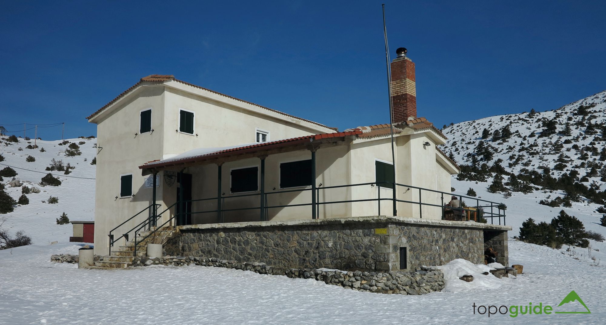
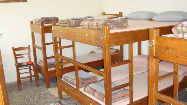
Ostrakina Refuge (P. Alexopoulos)
The Ostrakina refuge (Panos Alexopoulos) located at an elevation of 1,580m is operated by the Greek Mountaineering Club of Tripoli (EOS Tripolis) and can host up to 60 people. It has a bathroom with a shower – and yes, hot water in the afternoon – a kitchen, and a large dining hall. The refuge can be opened for groups of 10 or more people at a price of €12 per person [as of 2020]. It stands West under the summit of Ostrakina (1,981m) and is part of the E4 European long-distance trail. When operating the refuge is staffed with one guard.
There may be some updates as a new website has been uploaded [March 2024].
|

|
|
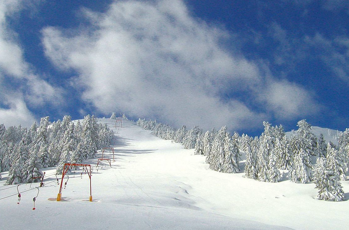
Mainalo Ski Center
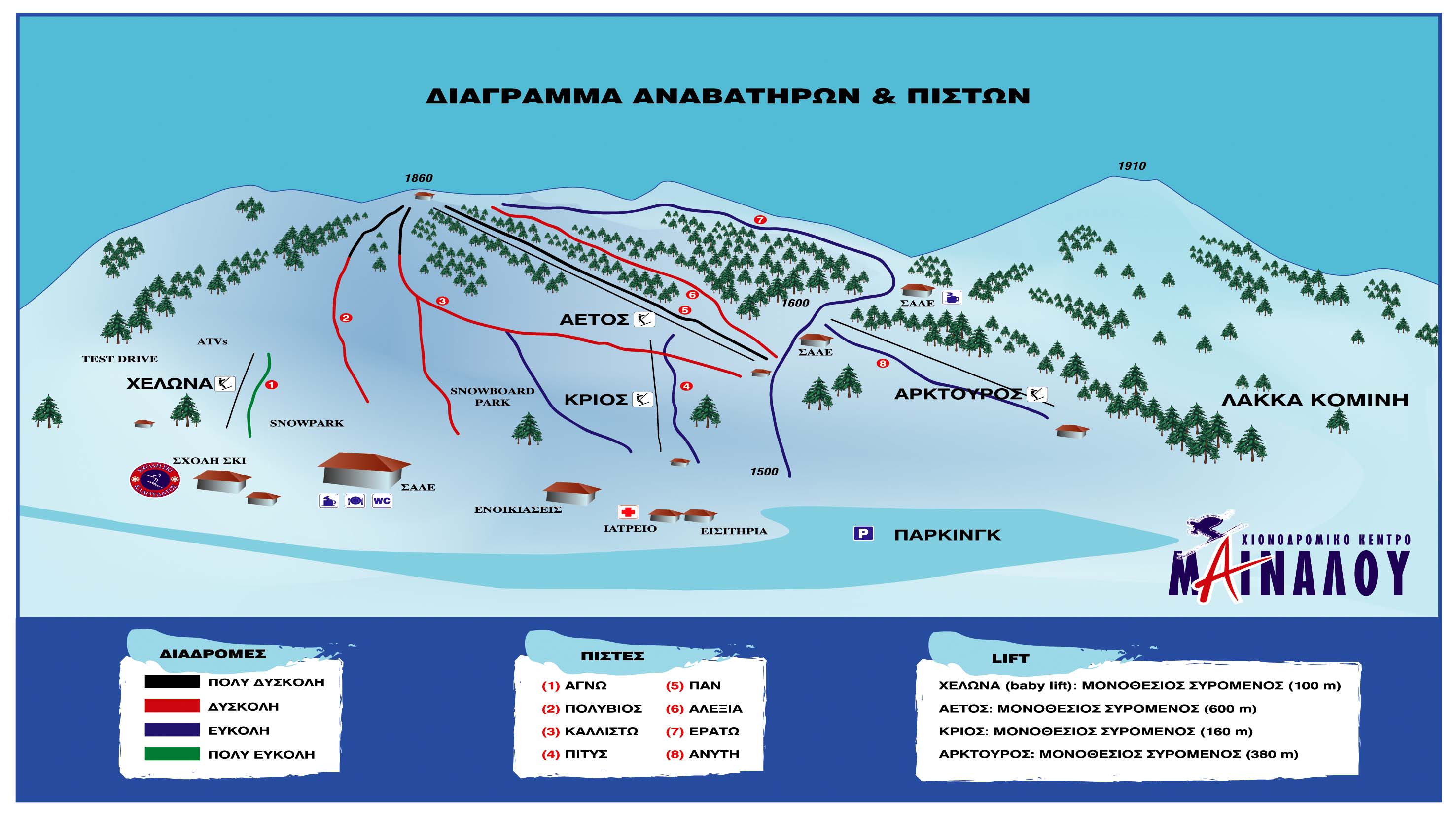
The Mainalon Ski Center is located on the Ostrakina plateau at 1,600m of elevation. The resort is pretty small, only boasting three ski lifts and gets seasonal snowfall – it is very close to Athens. The maximum elevation is 1,860m at the top of Aetos (Eagle) anchor lift, which provides access to 5 runs, 3 reds, 1 black, and 1 blue. The maximum elevation change is 360m. The resort has a main chalet at the bottom of the hill, along with the tickets and rentals, it also has a small coffee shop at the base of Aetos. The skiing is almost entirely under the treeline, with runs being cleared of trees and being somewhat well groomed. Runs 2, 3 and 6 sometimes remain ungroomed while 5 and 7 are usually very well groomed. There are moderate opportunities for side-country and freeride skiing. Touring is available on the backside of the hill.
According to the ski resort website, 2023 lift prices were between €8-€12 on weekdays and €10-€16 on weekends. Ski bus from Athens is at €15.
Authors Note: Personally, I find it to be one of the best single-day resorts in Greece, when it is open and there is fresh snow that is. Enough challenging slopes, many inbound features and small enough to fully explore in one day of skiing without it being too limiting.
Backountry Skiing & Snowboarding
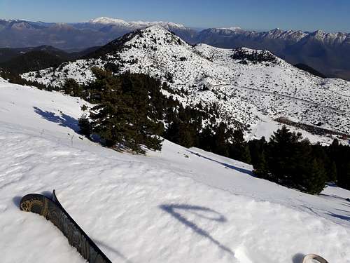
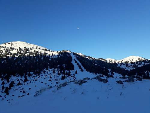
Accessing the backcountry for ski and snowboard touring is simple in this range, with both the ski center and a number of villages being at high elevations. There are, however, no designated ski touring routes or popular areas, the summit of Ostrakina (1,981m), Sfentami (1,870m), Mesovouni (1,860m), and Mavri Korifi (1,818m) are all in the vicinity of the ski resort. Other summits and areas, especially in the West are generally far from human activity and thus, can be dangerous. As usual Search & Rescue is lacking and can take a long time to reach the area, additionally there is no avalanche or snowpack reporting from the resort or any other organization.
Ostrakina Plateau
From the base of the ski resort, or the Ostrakina Refuge, it is possible to access the summits of Ostrakina (1,981m), Sfentami (1,870m), Mesovouni (1,860m) and, Mavri Korifi (1,818m). The two furthest are Ostrakina at about 2.5 hours and Mesovouni at 2 hours – or less if the lifts are used. Sfentami is the easiest to access and can be boot packed from the top of Eagle lift in about 30 minutes.
Aintinis Peak (1,849m)
Approaching from the West slopes and the village of Roeino it is possible to tackle the peak of Aintinis (1,849m) in what is a longer and more remote ski-tour. Follow the dirt road from Roeino until above the village, then follow the road until you reach the ravine leading from the peak. From there hike through the forest going East till you reach the alpine slopes of the SW aspect at 1,500m. From there hike up the slopes going North, the true summit is further North from the summit ridge. On the way down cross over the ridge from the true summit and ride the 300m of elevation delta between the false summit and the start of the trees. It may be possible to ski further down towards the road given good snow cover.
West Mainalo Area
It is generally possible to ski in West Mainalo given a good winter storm, although it is generally under the tree line and does not have large elevation differences. The summit of Pleiovouni (1,643m) can be skied from most aspects with the ride primarily through glades, it does, however, have a very long approach. The Southwest aspect has about 230m of elevation difference. The summit of Madara (1,585m) is both more visually distinctive and has less tree cover, it has about 250m of elevation difference on the skiable East face, it is situated above the village of Elati.
Find Out More
You can find all the information you need about skiing in and around the resort here in my article Freeriding in Mainalo.
Mainalon Trail
The Mainalon Trail is a non circular long distance trail that passes through and around the Mainalon range, it covers a distance of 75Km starting from Stemnitsa and ending in the village of Lagadia. The trail can be hiked in about two days by taking advantage of the many villages that you pass through. You can also run the village in less than one day, the advantage is that there are no elevation extremes and the trail is rather flat. The trail takes one through villages of cultural interest providing hikers the opportunity to visit picturesque monasteries and castles.
Find more details check the Mainalon Trail Official Website.
|

|
|
- Get accurate GPX files for the area via Hellas Path - Mainalo
- Anavasi.gr 1:40k Mainalo Area Map (€5) ISBN: 978-960-8195-66-0
- Anavasi.gr 1:22k Lousios River Area Map (€5) ISBN: 978-960-8195-29-5
Updated: March 2024.
External Links
Natura 2000 Area "Oros Mainalo"
Lousios River (Wikipedia)
Theodoros Kolokotronis (Wikipedia)
Area sanatorium converted into hotel, 2023. Article.
Snow Forecast Mainalo Ski Center
Ostrakina Refuge new website
EOS Tripolis Ostrakina Refuge website (old)
Mainalo Ski Center website
Freeriding in Mainalo, 2018, Article.
Mainalon Trail website
Hellas Path Trail GPX Database