
-
 32692 Hits
-
 87.76% Score
-
 25 Votes
|
|
Area/Range |
|---|---|
|
|
42.64240°N / 0.66340°E |
|
|
Hiking, Mountaineering, Ice Climbing, Big Wall, Mixed, Scrambling, Skiing |
|
|
Spring, Summer, Fall, Winter |
|
|
11167 ft / 3404 m |
|
|
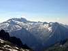
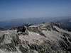
Overview
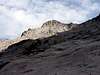
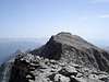
 South face
 North face
Names: Macizo de La Maladeta, Montes Malditos.
"Montes Malditos" is the spanish expression for "Damned Mountains". According to some books this terrible-sounding name has its origin in the primitive local name for the massif: Mala hita (meaning "bad rocks" or "bad upper regions"). The first french travelers in the area translated this local name into the french "Maladette", thinking it had something to do with the italian term "Maladetta" (feminin for "damned"). After that, Maladeta was a logical evolution and from the name of a single peak it came to be the term to know the whole massif. (info add for "eza")
The Maladeta Massif constitutes the most important and emblematic set of summits of the whole Pyrenees, not only for contains the highest point (Aneto, 3404m), but for the category and quantity of tops over 3000 meters that it contains. For centuries this range has astonished the mountaineers that for many years of legend have managed to conquer the summits. Great report of the history of the French and Spanish mountaineering has been written in these mythical summits.
For a long time the massif was removed from the civilization and was a hard task for the first conquerors to come up to it for what was adapted the name of Montes Malditos ("Damned Mounts") that still is correct to refer to this mountain range.
The Maladeta Massif is located in valley of Benasque in north of Huesca, just in the middle of the mountainous range of the Pyrenees (Pirineos).
 |
 |
 |
 |
 |
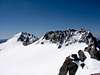
History-The Conquerors
 Pico Maladeta
 Aneto
AnetoI write some words about the first mountaineers on the summits of Maladeta. The first climb to Pico de la Maladeta in 1817 had special importance. When Parrot and Barrau reached the summit they thinked it was the highest of massif, and as well of the full Pyrenees, but they comtemplated the highest Aneto from the summit. A lot of years were needed to climb this peak.
| Peak | Date | Mountaineers | Route |
| Pico de la Maladeta | 29-september-1817 | F.Parrot & P.Barrau | Col de Rimaya |
| Pico de Aneto | 20-july-1842 | A. de Franqueville, P. de Tchihatcheff, B.Arrazau, O.Redonnet, P.Sarrió & J.Sors | South |
| Pico Russell | 1865 | H.Russell & C.Packe | Sout-east |
| Pico de Alba | july-1868 | H.Russell & J.Haurillon | - |
| Pico Tempestades | 21-august-1877 | H.Russell & C.Passet | shoulder SSE |
| Picos Cordier & Sayó | 25-august-1877 | H.Russell & C.Passet | - |
| Pico de Aragüels | august-1880 | H.Russell & F.Barreau | ridge ENE |
| Diente de Alba | 31-august-1882 | H.Russell & B.Courrége | - |
| Pico Maldito | 1882 | H.Brulle | Col Maldito |
| Punta Astorg | july-1901 | D'Astorg, H.Brulle, C.Passet & B.Salles | Col Maldito |
| Pico Margalida | 29-july-1905 | Le Bondidier & JM.Sansuc | South |
Getting There
The valley of Benasque is actually the most popular of the Pyrenees because it the signposting is good on the roads for the 3 big valleys of Pyrenees of the north of Huesca: Tena, Ordesa and Benasque.For approach to Benasque from Huesca: in the road on direction to Barbastro (N-240). After Barbastro we follow the indication to valley of Benasque to the C-1311 to Graus and the C-139 to Benasque across the beautiful gorge of Congosto de Ventanillo.
The approach of the principal summits has different trailheads but the principal trailheads are:
-Llanos de la Besurta (near the Hospital de Benasque) and refuge of La Renclusa in the north of Maladeta. Trailhead to Aneto, Maldito, Maladeta, Tuc de Mulleres...
-Bridge of Coronas at the end of the track of Vallibierna in the south of Maladeta. Trailhead to south route to Aneto, Aragüels, Vallibierna, Tempestades, Margalida, Russell...
-Puente de Cregüeña in the road between Benasque and Llanos del Hospital de Benasque. Trailhead to Pico de Alba, Diente de Alba, Mir, Sayó, Cordier...
 |  |  |  |  |
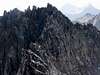
The summits
It exist a lot of summits, but I show the principal summits and not the aiguilles or little summits except the peaks of 3000m of the list of UIAA. List of the Maladeta Massif from North-West to South-East with the grade of difficulty of easiest route, generally the normal but in many cases with the aiguilles is easier the descent from a main summit as the Espalda de Aneto, Aguja Superior de Russell... than the route normal for rock-climbers:| Image | Peak | Meters | Route(grade) |
 | Aguja de Alba | 3054 | P.D. (II+) |
 | Pico de Alba | 3118 | F |
 | Diente de Alba | 3136 | F. |
 | Muela de Alba | 3118 | F. |
 | Diente de la Maladeta | 2888 | F. |
 | Punta Delmás | 3170 | F.sup. |
 | Pico Mir | 3185 | F. (I) |
 | Pico Sayó | 3228 | F. |
 | Pico Cordier | 3254 | F. |
 | Pico Le Bondidier | 3185 | F.sup. (II-) |
 | P.Collado de la Rimaya | 3265 | P.D. (II+) |
 | Pico de la Maladeta | 3308 | PD (II+) |
 | Pico Abadías | 3279 | F. |
 | Aguja Schmidt-Endell | 3335 | P.D.sup. |
 | Pico Maldito | 3350 | AD inf (II, III, II+,I+,I,II+) |
 | Punta Astorg | 3355 | A.D.inf.(II, III, II+,I+,I,II+,I) |
 | Aguja Haurillon | 3075 | A.D. |
 | Aguja de Cregüeña | 3043 | A.D. |
 | Aguja Juncadella | 3021 | F. |
 | Pico de Aragüells | 3037 | F. |
 | Pico del Medio | 3346 | F. sup. |
 | Pico de Coronas | 3293 | F |
 | Tuca de Collado de Coronas | 3286 | F. |
 | Punta Oliveras-Arenas | 3298 | F. |
 | Pico de Aneto | 3404 | F sup (I+) |
 | Aguja Daviú | 3350 | P.D.sup. |
 | Aguja Escudier | 3315 | P.D.sup. |
 | Aguja Franqueville | 3065 | P.D.inf. |
 | Aguja Tchihatcheff | 3052 | P.D.sup.(III) |
 | Aguja Argarot | 3035 | P.D. |
 | Pitón de Llosás | 2890 | SD/F |
 | Espalda de Aneto | 3350 | F.sup. |
 | Pta.Brecha Tempestades | 3274 | P.D.sup. (III-, III) |
 | Pico Tempestades | 3290 | F. |
 | Pico Margalida | 3241 | F sup (I+,I) |
 | Primer Resalte de Salenques | 3127 | A.D.inf. (III-) |
 | Segundo Resalte de Salenques | 3148 | D.inf. (V-) |
 | Torre de Salenques | 3111 | D.inf. (V-) |
 | Forca Estasen | 3028 | F.sup. (I+) |
 | Pic d'Aigualluts | 2708 | F. |
 | Pic de Barrancs | 2887 | F. |
 | Pico de Salenques | 2986 | SD/F |
 | Punta Brecha Russell | 3192 | F (I) |
 | Pico Russell | 3207 | F (I) |
 | Russell S.E. | 3205 | F. |
 | Russell Oriental | 3034 | F. |
 | Aguja Russell Superior | 3146 | P.D.inf. (II) |
 | Aguja Russell S.W. | 3029 | P.D. (II+) |
 | Tuc de Mulleres | 3010 | SD/F |
 | Tuca de Culebres | 3051 | F. |
 | Pico Vallibierna | 3056 | F. |
 |
 |
 |
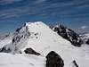
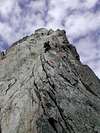
Peak of Maladeta (3.308m)
The peak Maladeta give the name to the full massif but it's not the highest (is Aneto). The first explorers of the massif they believed that this peak was the highest of Pyrenees but after the first conquest in 1817 they discovered one mountain highest, the less knowed Aneto (Nethou). |  |  |  | |
Red Tape
No permits required.Located in the Posets-Maladeta's Natural Park with your rules (no free camping, no fire,...)
 | |  |  |
When To Climb
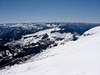
June to september.In summer the glaciers are a mass of grey ice (It is possible to be necessary to use crampons and ice-axe) and the routes have a lot of stones.
In spring (march-may) generally remain a lot of snow and is a good time for the use of ski, travelled-ski, snowshoe,...but the access of some summits is very complicated (rock climbing is dangerous with softened snow).
 |  |  |
Camping
Mountain hut of La Renclusa.Many hotels in village of Benasque.
 |  |  |
Mountain Conditions
External Links
- Fed.Aragonesa de Montaña
Info of mountain huts of the FAM, routes, climbing,...
- Map of Benasque
General map of the Natural Park of Posets-Maladeta
- Pyreneisme
Information about the heroes of first years: Astorg, Rusell, C.Passet, Brulle... (in french)
- Desnivel #131 Aug. 1997
In this issue of Desnivel, there is a description of most of the routes of MALADETA ORIENTAL South Face. These 300 metres vertical wall offers you one of the best alpine climbs in the Pyrenees.
- Cerler
info about the ski resort of Cerler and all the valley of Benasque.