-
 9379 Hits
-
 89.01% Score
-
 28 Votes
|
|
Mountain/Rock |
|---|---|
|
|
42.62449°N / 0.66591°E |
|
|
Download GPX » View Route on Map |
|
|
Mountaineering, Scrambling |
|
|
Spring, Summer, Fall |
|
|
10633 ft / 3241 m |
|
|
Overview
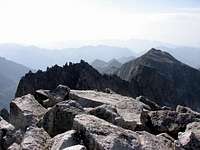
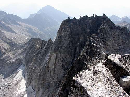
The peak Margalida, or Margalide in french, it’s known thanks to its situation in an important point of the ridges of Maladeta massif. From many points is difficult to see as a peak, but the peak seem as a long ridge. Really it’s a main peak but personally and for many mountaineers it’s a complementary climb of another great peaks of the area like Tempestades or Russell, or it's a point to cross in the classic rock-climbing of ridge Salenques-Tempestades. I think that nobody climb only Margalida.
Because the route is not easy, I think it’s necessary to make a page for this peak. All the routes have stepcrossings of rock-climb I+ or II, exposed. The people with experience generally don’t use a rope in this summit (if you come from the ridge of Salenques with a rock-climb of IV- it's ridiculous) but the beginners or mountaineers without experience… they need a rope to not fall in the impressive walls (the fall in north side is deadly). It’s important to say that exists a normal route (P.D.inf., II-) from the col with the peak Tempestades across the west ridge but generally it’s possible to descent across some channel of free stones in the East side (hard to ascent across it) and it’s not necessary the return across the exposed ridge.
First climb and origin of the name
First climb: on 29-july-1905 by L.Le Bondidier and J.M. Sansuc.
First climb of ridge Salenques: 22-september-1922 by Jean Arlaud and Charles Laffont.
Margalide was the name of first wife's Le Bondidier and he gave her name to the summit.
Secondary summits:
The collectors of three-thousands have some secondary peaks in the ridge Salenques-Margalida (always known as Salenques-Tempestades, because the ridge follow to Tempestades and Aneto):
-Forca Estasen (3,028m): I+, it's the first elevation in the classic ridge Salenques-Tempestades from Pic Salenques (2,986m).
-Torre de Salenques (3,011m): it's probably the most difficult peak of 3000m of Pyrenees according with the offical list of UIAA. From Pic Salenques-Forca Estasen: IV- and V- (D-).
-Primer resalte de Salenques (3,127m): IV and IV- from la Torre de Salenques . III- (A.D.inf.) from the summit of Margalida (really nobody descent the ridge Salenques-Tempestades but it's possible).
-Segundo resalte de Salenques (3,148m): II from the Primer Resalte (P.D.inf.).
Getting There
Approach to Benasque from Huesca: in the road on direction to Barbastro (N-240). After Barbastro we'll follow the indication to valley of Benasque to the C-1311 to Graus and the C-139 to Benasque across the beautiful gorge of Congosto de Ventanillo.-Puente de Coronas: across the track of Vallibierna in the south of Maladeta Massif. The entry is signaled in the road from Benasque to Hospital de Benasque. After the cross of Cerler we'll arrive to the signal "Vallibierna/Senarta" where's the track of entry to camping area of Senarta. At end of plain in right side is the forest track of Vallibierna.
-La Besurta: the entry of North of massif is the same of normal route of Aneto across Refuge La Renclusa.
Red Tape
-Summer (july-august-september): the track of Vallibierna and the road to La Besurta are closed and we'll must to pay the bus.
-Spring (may-june)-Autumm (october-november): is possible the approach in car but the track of Vallibierna it's not always in good conditions early in the season after the winter. In october-november it's possible the first snowfall and is very dangerous to drive in the track. The access to La Besurta is a good road.
-Winter: track of Vallibierna closed for risk of avalanches.
The best option is always to search information about the access to Vallibierna in tourism office of village of Benasque
Camping
Camping is not allowed in the area generally but you have many options:Camping:
-Camping of Senarta (at the beginning of the track of Vallibierna): very economic, with w.c. and green zone to put the tent.
-Camping Aneto.
-Camping Ixeia.
Refuges:
-Refugio de Coronas (at the end of the track): free hut with space for a few of persons in beds and the floor.
-Refugio de la Renclusa: not in the normal route. Usefull the previous day if you'll climb the Salenques-Tempestades ridge.
Hotels:
A lot of hotels in the village of Benasque, but the nearby hotel is Hospital de Benasque (actually an hotel), but I think is very expensive to mountaineers.


edouet - Feb 11, 2008 8:37 pm - Hasn't voted
Origin of the nameThe peak was first climbed by French Climber Le Bondidier. He named this mountain " Pic Margalide " as it was his Wife's first name.
Rafa Bartolome - Feb 12, 2008 3:43 am - Hasn't voted
Re: Origin of the namethanks, I add the information.