
-
 19046 Hits
-
 83.1% Score
-
 16 Votes
|
|
Area/Range |
|---|---|
|
|
42.63110°N / 0.68140°E |
|
|
Hiking, Mountaineering, Sport Climbing, Ice Climbing, Mixed |
|
|
Spring, Summer, Fall, Winter |
|
|
11168 ft / 3404 m |
|
|
Overview

The great valley of Benasque at center of Pyrenees is the "king" of the range containing the two highest mountains, Aneto (3404m) and Posets (3375m).
The valley has some several importants massifs: Perdiguero-Maupas, Posets and Maladeta.
The village of Benasque (1.212 hab., 1.138 metres) is a tourist place of first order: hotels, restaurants, stores, shops, campings, holiday cottages, health's center, office of tourism.
A part of the area is natural park, the parque natural Posets-Maladeta, protected by the governement of Aragón.
Getting There
Ver mapa más grande
Maladeta Massif
The Maladeta Massif constitutes the most important and emblematic set of summits of the whole Pyrenees, not only for contains the highest point (Aneto, 3404m), but for the category and quantity of tops over 3000 meters that it contains. For centuries this range has astonished the mountaineers that for many years of legend have managed to conquer the summits. Great report of the history of the French and Spanish mountaineering has been written in these mythical summits.
-Mountains: Aneto (3404m), Maladeta (3308m), Maldito (3355m), Russell (3207m),...see the page of Maladeta Massif for a full list of all the summits.
-Trailheads: all the trailheads are possible to reach from the village of Benasque.
-Besurta: north access to Aneto and all the peaks to the west to the Pico de Alba. On summer the access is regulated and it's necessary to pay the bus. It's the normal route to peaks as Aneto, Maladeta or Pico de Alba.
-Vallibierna: south access to the peaks of East side from Aneto to Vallibierna. The forest track is a little hard for the cars. It's the normal route for peaks as Tempestades, Russell or Vallibierna. On summer the access is regulated and it's necessary to pay the bus.
-Refuges:
-Refugio de la Renclusa (40 min of walk from La Besurta) .
-Free Hut of Puente de Coronas (at the end of forest track of Vallibierna).
Perdiguero-Gourgs Blancs
 Perdiguero's group
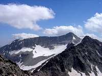
The Perdiguero is the highest point of this range but it also contains a lot of important summits.
Mountains:
Clarabide (3.020m), Gías (3.011m), Gourgs Blancs (3.129m), Spijeoules (3.067m), Seils dera Baquo (3..110m), Pico del Portillon de Oô (3.050m), Picos Crabioules (3.110m, 3.116m), Lezat (3107m), Quayrat (3060m), Maupas (3.109m), Boum (3006m), Sacroux (2.675m)
Trailheads:
-Puente de Literola: in the road to Hospital de Benasque to the village of Benasque. Normal route to Perdiguero and Crabioules.
-Remuñe: end of the road in the crossroad of Hospital de Benasque. It's the trailhead to Maupas and Boum from spanish side but the normal route it's in french side (north).
Posets-Eriste

Posets is the second highest peak of the Pyrenees and it has important mountains around it.
Mountains:
Posets (3.375m ), Espadas (3.332m), Diente de Llardana (3.085m), Gran Eriste (3053m), Forqueta de Eriste (3.007m), Bardamina (3.079m), La Paul (3.078m), Veteranos (3.125m), Gemelos (3.160m).
Trailheads
-cascada de Espigantosa: in a forest track from the village of Eriste. Walk-up of 3-4h to the Refugio Angle Orús. Normal route to Posets.
-Biados: private refuge in the valley of Chistau, access to Eriste or Posets.
South: El Turbón
 El Turbón
At South of Benasque before at East or South-East of Congosto de Ventamillo are some peaks very interesting as El Turbón (2.497m) and its own massif. It's not in Benasque and it don't appears in some of the maps of the valley but I think this is a good area to include because the roads of approach are the sames.
Around El Turbón are some interesting peaks as Baziero (2,116m) or Amurriadó (1,790m) with nice panorama.

Links
Cerlerinfo about the ski resort of Cerler and all the valley of Benasque.