
|
|
Hut/Campground |
|---|---|
|
|
45.91670°N / 7.88330°E |
|
|
Spring, Summer, Fall, Winter |
|
|
11384 ft / 3470 m |
Overview
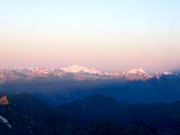
Mantova hut is a hut with a huge offer of routes in the Monte Rosa area. You can climb 15 4.000 m mountains from the hut. It´s located at 3.470 m and you can see Castor, Il Naso, Lyskamm and far away Gran Paradiso, Grivola and Mont Blanc.
The hut operators are very friendly and the lunch is good. Many mountain guides favour Mantova hut over Gnifetti hut as the lunch is better.
How to get there
By car from the North via Mont Blanc tunnel or Simplon pass to Italy and then to Alagna or Gressoney.By public transport it needs a long time as the connection is bad and there are less buses and trains…
From Alagna or Gressoney via ropeway to Salati pass (2.900 m; ropeway to Punta Indren doesn´t exist anymore!) and then on rocks and glacier (easy) via Stolemberg to Mantova hut in max. 2 hours.
Another possibility is to reach the hut from the Swiss side: Monte-Rosa-Hut – Lis Col - Cabanna Gnifetti - Rifugio Città di Mantovia
Routes overview

Il Naso (4.272 m)
Lyskamm East (4.527 m)
Lyskamm West (4.480 m)
Castor(4.226 m)
Pollux (4.091 m)
Nordend (4.609 m)
Dufourspitze (4.633 m)
Zumsteinspitze (5.663 m)
Signalkuppe (4.554 m)
Parrotspitze (4.432 m)
Ludwigshöhe (4.341 m)
Schwarzhorn (4.322 m)
Vincent-Pyramide (4.215 m)
Balmenhorn (4.167 m)
Punta Giordani (4.046 m)
Hut informations

Coordinates: 631.800/082.700
Telephone: 0039 - 0163 781 50
Sleeping places: 90 (Winter room 20 )
Opening times: July - September and Ski season