
-
 18613 Hits
-
 81.18% Score
-
 13 Votes
|
|
Route |
|---|---|
|
|
45.99893°N / 7.97509°E |
|
|
Hiking |
|
|
Summer, Fall |
|
|
Half a day |
|
|
Easy Hike |
|
|
Overview
 Mattmark
 Joderhorn
 Taelliboden
At the end of the Saas-valley in Switzerland is the Mattmark storage-lake. From this reservoir you can do some day trips like Stellihorn, Jazzihorn or Spechhorn. The most popular trip from this origin is the easy hike to Monte Moro Pass (2.868m). It is an old ancient pass between the swiss saas-valley and the italian Valle Anzasca a sub-valley of the Valle d'Ossola. It´s very curios that this very easy transit over the main ridge of the Alps didn´t get as famous as other passes. You can do the route to Monte-Moro-Pass and return in 4 hours. From Monte Moro Pass you have a fantastic view to the famous east-face of Monte Rosa, the highest wall in the Alps. Near the pass is a big statue of the Virgin Mary and the Rifugio G. Oberto (2.819m). From the pass you have different possiblities, you can return to Mattmark, ascend to Joderhorn (3.035) or Monte Moro (2.985m), or descend to Macugnaga on the italian southern side. I used this trip as a acclimatization trip for higher ascents around Saas Fee.
Route Description:
From the parking at Mattmark you can walk at the eastern or western bank of the lake. Both tracks are heading to the end of the reservoir. There is a small customs-building. The track to the end of the lake is mostly flat. From the end of the storage-lake you ascend towards Taelliboden (2.492m), a small flat area at the Taelliboden-glacier. From Taelliboden follow the track to the right side. Now, the track is steeper and runs over old stairs . Be careful, some passages are very slippery and in case of bad weather they could be icy and dangerous. This track leads without any problems of orientation to the unspectacular Monte Moro Pass. The statue of the Virgin mary is on the right side on a higher rock. The way to the statue and the descent to the Rifugio G. Oberto are secured. On my trip (August!) the descent to the Rifugio was totally icy. Once again, be careful! The route up and down takes ~4 hours.
Getting There
From Visp in the Rhone-valley in Valais/Wallis drive towards the south to Stalden. At Stalden the valley devides to the Matter-valley and Saas-valley. The Matter-valley leads to Zermatt, the famous village at the foot of the Matterhorn. Choise the Saas-valley and drive towards Saas-Grund, the origin for many 4000m-climbs. From Saas-Grund continue to the south to the Mattmark storage-lake. There are parkings.
Views from Monte Moro Pass
 Monte Rosa East Face Monte Rosa East Face |  Monte Rosa East Face Monte Rosa East Face |  Incredible view Incredible view |
|---|
Essential Gear
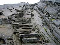 The stairs
 cable-car station
Mattmark storage-lake
 Mattmark
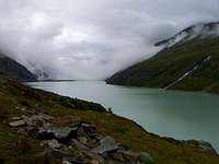 Mattmark from west-bank
The Mattmark storage-lake was built from 1960 - 1967 to supply the region with water and electricity. The dedication ceremony was in 1969. 88 workers died when a glacier-cave-in hit the work at the damn in 1965. The damn is 780m long. The volume is 101 Mio m³. The lake is 3,2km long.
External Links
Maps and books
- Kompass WK 117 Zermatt-Saas Fee - 1:50.000 - ISBN: 3-85491-466-0
- Michael Waeber / Hans Steinbichler - Oberwallis - ISBN 978-3-7633-4127-6