-
 16587 Hits
-
 87.23% Score
-
 24 Votes
|
|
Route |
|---|---|
|
|
45.91530°N / 7.34410°E |
|
|
Summer, Fall |
|
|
Overview
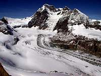
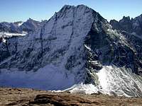
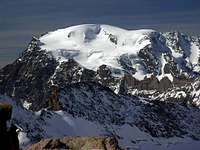
Mont Avril, (3.347m), is considered a smaller brother of Mont Gele. Mont Avril has a very little glacier, outside normal route, same iced north face, and great sightseen on Grand Combin, Velan, Arolla, Otemma, all Valaisan/Aostan peaks. From its summit is possible to observe the cableway arriving at Aiguille du Midì! Unfortunately, Mont Blanc is hidden from Mont Velan and his great northern iced circus. Mont Avril is easier, in comparison with Mont Gelè, because there isn't any glacier to cross and don't require technical tools, crampons, ice-axe. The E ridge is very large and confortable, never exposed, ideal for beginners looking for an important summit. Althought Mont Avril ascent is very easy, this top is only for well trained/shaped hikers. The route described is very long: about 10 kilometers one-way!
Getting There
Common start place: Variney village.
- From Turin, Milan. Leave motorway A5 in Aosta Est, then follow Grand Sant Bernard tunnel direction. Once passed the second tunnel there is Variney village.
- From Switzerland (Grand Saint Bernard Pass or Tunnel). Drive to Aosta direction. 4 km before arriving in Aosta, just before first tunnel, there is Variney village. Turn right for Valpelline and Place Moulin direction.
- From France via Mont Blanc tunnel or Petit St. Bernard pass. Follow Aosta direction via SS.26. or Motorway A5 (get out at AOSTA OVEST, because there isn't an exit in Aosta Est driving from Aosta to Turin direction). Once reached Aosta, follow Grand St. Bernard direction. If you are on the old road for Grand St. Bernard, it joins the new one at Variney. Follow Valpelline, Place Moulin Lake direction. Once passed Valpelline village, turn left to Ollomont. Go ahead to Glassier direction (follow always "main" road) until road ends. Park the car at the big ground square. 150 meters before arriving at the park, there are a plenty of yellow panels. Here it is the headtrail to Conca di By (By is pronounced as "(to) Be" in english), Fenetre Durand, Mont Avril other than many other places spreads all over By region.


