
-
 3603 Hits
-
 78.27% Score
-
 9 Votes
|
|
Mountain/Rock |
|---|---|
|
|
41.92618°N / 14.01070°E |
|
|
Download GPX » View Route on Map |
|
|
Hiking, Skiing |
|
|
Spring, Summer, Fall, Winter |
|
|
6985 ft / 2129 m |
|
|
Overview
 Monte Rotella seen from the north Monte Rotella seen from the north |
To the very west of the Majella mountain range in the Abruzzi Region of Appennino Centrale there is a long ridgeline of nearly 20km length which culminates in two mountains, Cima della Fossa (1950m) and Monte Rotella (2129m). While its height is not overly impressive the whole ridgeline is barren so that no obstacles spoil the views. Thus summitting those two mountains can be a very rewarding experience, with the Abruzzi mountains forming the backdrop near and far.
There are two trailheads at both ends of the north-to-south running ridge, the city Sulmona in the north and the picturesque skiing village Pescocostanzo in the south. Elevation differences are huge - 1300m at Pescocostanzo, 2129m on Monte Rotella and 400m at Sulmona. A full traverse of the ridge requires clever organization and lots of stamina. Therefore most visitors hike the southern half from Pescocostanzo and back.
 |  |  |
Like all surrounding mountains, Monte Rotella is made up from limestone. It is a withered type of limestone, which makes the mountains look like smooth, rolling hilltops. At closer inspection there are a lot of nooks and crevices which are perfect beds for wildflowers. In spring the slopes of the mountain are covered in blue and yellow violets (viola della majella, Viola magellensis).
 |  |  |
There are a few rocky sections on the north ridge of Monte Rotella right close to its summitBut since the ridge is wide there is little difficulty involved with them. The path winds among them, sometimes avoiding obstacles but most of the time staying right on the middle of the crest. In this section there is the option to descend towards Rocca Pia, a village to the west, by the very steep Vallone di Rotella. The descent involves roughly 1000m of elevation loss.
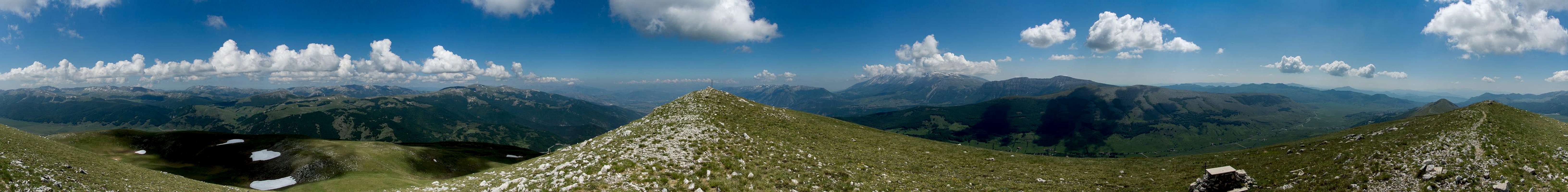
360° Summit Panorama
  |
Getting There
 Looking down Vallone della Rotella towards Rocca Pia
- From Rome:
- Take motorway E80 / A24 from Rome to Torano.
- Switch to motorway A25, direction Pescara.
- At the exit Pratola Peligna / Sulmona switch to SS17 south, passing Sulmona.
- After Rivsindoli switch to SS84 and after a few km you'll reach Pescocostanzo
- Take motorway E80 / A24 from Rome to Torano.
- From Pescara
- Take motorway E80 / A25 westward in direction Rome.
- At the exit Pratola Peligna / Sulmona switch to SS17 south, passing Sulmona.
- After Rivsindoli switch to SS84 and after a few km you'll reach Pescocostanzo
- Take motorway E80 / A25 westward in direction Rome.
Route
 On the Monte Rotella north ridge
The route from either side of the ridge is absolutely straightforward. From Sulmona just follow the ridge. From Pescocostanzo head up the road to the ski lift, which turns into a dirt road to the upper ski station. From there a path heads up across the east slope of the mountain until it reaches the ridgeline. Follow this across Cima della Fossa until you reach the summit of Monte Rotella.
Red Tape
 A bed of Viola della majella (Viola magellensis)
Parco Nazionale della Majella.
On the slopes above Pescocostanzo ski runs have been developped. The usual national park restricions apply to the area above the runs. Sheep, cattle and horses graze on the mountain but there are neither gates nor fences.
Weather Conditions
 Monte Rotella seen from the south
Accommodation
There's ample accommodation'options in the area, however rather hard to find. Google searches often end up at the tripadvisor, casamundo or booking.com portals. There is a thriving community of British expatriates, many of whom offer apartments for rent. Maybe a good starting point is this sitewelcometosulmona.com
Maps & Books
Maps
- Digital Maps
- Regular Maps
I haven't been able to find a map for this area. Any suggestions are welcome!
Books
- Abruzzen
Heinrich Bauregger
Rother Verlag
ISBN 978-3-7633-0413-2
- Abruzzen