
|
|
Mountain/Rock |
|---|---|
|
|
39.78610°N / 79.1761°W |
|
|
Somerset |
|
|
3213 ft / 979 m |
|
|
Overview
Mount Davis is considered the highest mountain in Pennsylvania (although recent data indicates there is an area 1' higher on the mountain than the State designated, the State of Pennsylvania has not made this official yet or taken steps to make access to that area less than a mile to the north). Mount Davis is the summit of 30-mile long Negro Mountain, and roads take you very near the summit. Several hiking trails encircle the highpoint, but none dip below 3,000 feet, meaning the mountain has little prominence from any vantage point. Views from the top are nice, especially with the very tall obversation tower, that allows for expansive views in all directions. You are surrounded by mountains, and you can also see modern wind turbines on a nearby ridge.
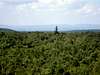
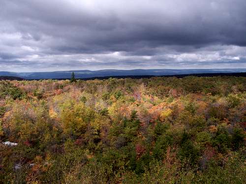 View from the summit
Mt. Davis itself is named for the man who surveyed it, John N. Davis, who was a pioneer farmer in the Negro Mountain district, land surveyor and educator. He owned the tract on top of Negro Mountain. The Davis brothers, sons of the pioneer erected a flag pole at the high point to be used at the ceremony.
Mount Davis is located in Forbes State Forest, which offers recreational activities, and is frequently visited by Pittsburgh natives, living about 1 and 1/2 hours drive from the area.
 |
 |
 |
 |
 |
Getting There
Mount Davis is located in Somerset County in Southwest Pennsylvania, near the Maryland Border. The nearest major highways are the Pennsylvania Turnpike and I-68 in Maryland. From either highway, you need to get onto Route 219, a major routeway in Pennsylvania and Maryland. In fact, if you travel Route 219 South for another hour, you can reach the trailhead to Maryland's highest mountain, Backbone Mountain.
There are good road signs pointing to Mount Davis. To reach the summit, you can either take the summit road for 1 mile to the parking lot, or park at the Picnic area, which is just past the summit road, and hard to miss. From there, you can take the highpoint trail about 0.8 miles to the summit, with an elevation gain of about 200 feet.
Directions from the major interstates
From the North (PA Turnpike) you need to get to the town of Meyersdale, where you will head West once you see signs for the highpoint. From the South (I-68), you will head West from the town of Salisbury, Pennsylvania. See the map below for directions from Salisbury (to the lower right of the map).
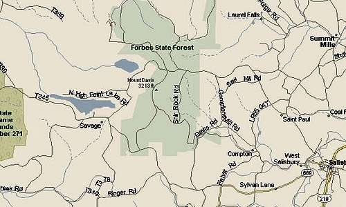 Map of local roads to the highpoint
Thanks to Ryan Cragun for this map.
 |
 |
 |
 |
Trails
There are several trails surrounding the highpoint, designated for hiking, cross-country skiing, and equestrian use.
High Point Trail
This old CCC trail connects the Mt. Davis Picnic Area and the High Point. This 0.8 mile trail provides easy walking. It goes through the Natural Area, and part of the area destroyed by fire in 1951.
Mt. Davis Trail
This 0.1 mile trail connects Shelter Rock Road with the High Point. Many of the trees and plants common to the area are found here.
Shelter Rock Trail
This 1.0 mile trail originates on the southeast portion of the observation loop, and exits onto Shelter Rock Road. Points of interest along the trail include a stand of pitch pine, the stone quarry from which stone was used to build a shelter at the High Point, sorted stone net, and frost and water pockets.
Tub Mill Run Trail
This rocky 2.8 mile trail connects High Point Trail with South Wolf Rock Road. This trail winds along the east slope of Negro Mountain, paralleling Tub Mill Run for part of its length. Along the stream, large blocks of moss-covered sandstone are found.
Timberslide Trail
This 0.5 mile trail connects Tub Mill Trail with Shelter Run Road.
Laurel Run Trail
Originally built as a CCC fire trail, this 1.9 trail stretches from Christner Road to South Wolf Rock Road.
Wolf Rock Trail
Only 0.8 miles long, this path was built by the CCC and joins Laurel Run Trail and South Rock Road.
Shelter Rock Road
This 1.6 mile road, which is closed to vehicular traffic, serves as a hiking trail and forms the eastern boundary of the Natural Area.
Livengood Trail
Livengood meanders 1.1 miles between Laurel Run Trail and South Wolf Rock Road.
Source
Camping
Camping in the Forbes State Forest is restricted to backpack-type camping. Camping out of vehicles or campers is not permitted. Permits for camping are required only if campers stay more than one night at any campsite. All campers are encouraged to obtain a permit in case you are overdue or if someone needs to reach you.
Campers must:
-Camp at least 100 feet from any stream
-Camp at least 200 feet from and out of sight of roads
-Camp at least 25 feet from and out of sight of any trails
-Keep field privies at least 200 feet from any water source
-Pack out all trash
-Not have campfires when wildfire danger is high
Source
Also see this link for information on campsites in the area from the PA Department of Conservation and Natural Resources.
Red Tape
No permission is required to park at the highpoint, nor are there any fees for the use of the park. There are no seasonal closures but winter can offer seasonal snow, patches of fog and rain.
The State has not yet made access to the new area being considered as a new highest point, however, this area can be bushwhacked just off the road.
Contact the regional office for most updated information:
Forbes State Forest
PO Box 519 (Del. Rt. 30E)
Laughlintown, PA 15655
(724) 238-9533
FAX: (724)238-9827
When To Climb
Mount Davis can be hiked all year. The trails tend to be overgrown during the summer, so winter or early spring are really the best times to visit. Unfortunately, winter snow can occassionally close forest roads near the top. For mountain conditions please call the Forbes State Forest office to obtain the current mountain conditions. The phone number is: (724) 238-9533.
External Links
- Trail Map
Article on Mount Davis, including a clear, simple trail map. - General Information
Information on the highpoint, including history and hiking info. - Weather
Weather for the nearby town of West Salisbury
Scott - Jan 26, 2024 8:24 pm - Voted 10/10
Not the highest point in PennsylvaniaIt has been discovered using LiDAR that Mount Davis is not the highest point in Pennsylvania. It is to the north and here: https://www.listsofjohn.com/mobile/peak/218278 That point is also much more difficult to reach and is said to be a hands on your knees bushwhack. See this trip report: https://www.listsofjohn.com/PeakStats/TripReport.php?Id=24574&pkid=218278
hgrapid - Jan 28, 2024 7:54 am - Hasn't voted
Re: Not the highest point in PennsylvaniaThanks Scott. I made a note. I wonder when this will be made official - and beyond that - when the State of Pennsylvania will modify the park to enable better access from the new summit.
Scott - Jan 29, 2024 8:41 pm - Voted 10/10
Re: Not the highest point in PennsylvaniaAs far as on the official maps, maybe never. The USGS has known for many years that some of their elevations are in error on the topo maps, but even when it is known it has gone many decades without the correction. Some errors have been known at least since the 1980s. Mountain summit elevations just aren't a priority for the USGS. I have no idea about having the point made more accessible. Of note, Pennsylvania isn't the only state where the high mountains moved. Oklahoma has too. I was there (Black Mesa) and went to the new highpoint, but it's so flat up there I can see why even a surveyor would have a hard time finding the highest point. Delaware has moved too (I have no desire to go there, but for those that do), but I think this was known even before LiDAR. in Michigan Mt. Arvon and Mt. Curwood both came out at 1,979'. It is unknown which one is higher and either one could be. Apparently they are within inches of each other. Kings Peak has no LiDAR coverage yet, but it is interesting to note that before 1966 all maps and surveys showed that South Kings Peak was higher. There is a remote chance (but certainly not zero) that South Kings is higher, but that remains to be seen. It probably isn't, but it's possible.