
-
 21084 Hits
-
 91.75% Score
-
 36 Votes
|
|
Mountain/Rock |
|---|---|
|
|
37.13670°N / 118.6678°W |
|
|
Hiking, Mountaineering |
|
|
Spring, Summer, Fall, Winter |
|
|
13503 ft / 4116 m |
|
|
Overview
This attractive peak forms a horse-shaped ridge, along with Mt. Huxley and Mt. Warlow, located just west of the Sierra crest in an area known as the Evolution Basin. Mt. Fiske is one of the “Evolution Peaks” and is situated near the southern end of the curved, 8-mile ridgeline described as the “Evolution Traverse.” The peak was named after one of the 19th century pioneers of the science of evolution.The west summit is the peak’s high point. The peak features a table top summit block. The Mt. Fiske Glacier is below the peak’s north face.
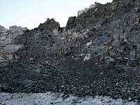
 Mt. Fiske and part of Mt. Fiske Glacier
 Clyde Spires (R)
Directly west is Mt. Huxley (13,086’), while Mt. Haeckel (13,418’), Mt. Wallace 13,377’) and Clyde Spires (13,240+’) line up north to southeast from Fiske’s summit.
The most direct route to Mt. Fiske approaching from the east is from the Lake Sabrina Trailhead (9,128’).
The routes described by Secor, The High Sierra: Peaks, Passes and Trails, 2d ed., at page 287 are: [1] Class 4--the North Ridge; [2] Class 2/3- the Northeast Ridge (climb the ridge from the basin west of Mt. Wallace to the lower east summit and continue to the higher western summit); [3] Class 2 routes--the West Face (ascend the chute in the center of the West Face from the cirque between Mt. Fiske and Mt. Huxley), the Southeast Ridge (from Helen Lake near Muir Pass go north to gain this ridge) and the Southwest Ridge (ascend the ridge from the saddle between Mt. Fiske and Mt. Warlow); and [4] Class 1--the broad slope to the east of the Southwest Ridge).
In addition, if approaching via Echo Col (12,400+’), the peak can be ascended on its eastern slope, Class 2-3.
 Echo Col (12,400+') is "atop a chimney marked by black rock." Secor.
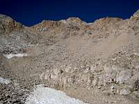 Route via Eastern Slope
 View on ascent to Mt. Fiske by its east slope
Getting There
From Interstate 395 in Bishop, take Highway 168 west 23 miles to the Lake Sabrina Trailhead. This trailhead is on the left side of the road just before you come to the large parking area next to Lake Sabrina. There is no overnight parking in the vicinity of the trailhead. You will have to park your vehicle about ½ mile back from the trailhead.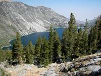 Lake Sabrina
Red Tape
Wilderness permits are required for overnight camping. There is a wilderness permit quota in effect between May 1 and November 1 by which 60% of the permit quota is allocated to advance reservations ($5.00 per person) and 40% is made available gratis on a walk-in, first-come-first-served basis. See the link below to the Inyo National Forest website for current information. You can also visit or call the main permit office regarding permits:Inyo National Forest Wilderness Permit Office
873 North Main Street
Bishop, CA 93514
Reservation Line: 760.873-2483
Permit Fax Line: 760.873-2484
Wilderness Information: 760.873-2485
Camping
Camping is allowed in most places in the John Muir Wilderness and in the Sequoia/Kings Canyon National Wilderness that surround Mt. Fiske. On the east side of the Sierra crest, Hungry Packer Lake and Moonlight Lake provide good sites. Echo Lake is closer to the peak than the other two lakes, but suitable camp sites are extremely limited (they are on the west side of the lake) because of the rocky terrain.On the west side of the crest, there are lots of camping opportunities along the John Muir Trail.
 Looking SE from Echo Lake (11,602'). Camp sites are scarce at Echo Lake
When to Climb
May to October is the prime climbing season. Early in the year, there is usually a lot of snow obviously necessitating more equipment. However, that may be preferred to traveling on the talus.Mountain Conditions
Check the National Weather Service for the Bishop area or the Sierra Weather Page for current conditions.For road conditions specifically, check with CalTrans or call 1-800.427-ROAD.
Other Information
USGS Topos Mt. Darwin 7.5 Mt. Thompson 7.5Other Pertinent Links
Eastern Sierra Logistical CenterSequoia-Kings Canyon National Park
John Muir Wilderness