
|
|
Mountain/Rock |
|---|---|
|
|
36.58814°N / 118.31436°W |
|
|
Hiking, Mountaineering, Scrambling |
|
|
Spring, Summer, Fall |
|
|
13440 ft / 4097 m |
|
|
Overview
Situated in the southern High Sierra in the Mt Whitney region, Mt Hale rewards the climber stunning views from its summit. Although somewhat overshadowed by other peaks in the area, the northern and eastern facing slopes are vertical escarpments providing the more adventurous some truly technical challenges. Mt Hale was named by the Sierra Club and honors the famous American astronomer George Ellery Hale, who among other things, was responsible for the development of the Wilson observatory located on the mountain with the same name (a popular Southern California hiking and city view venue).Most people choose to combine Mt Hale with Mt Young as they are separated by less than a mile and 500 feet of elevation. The easiest approaches are Class 1 and for an experienced hiker, the peak can be summited in a day from the Whitney Portal. Mt Hale and Mt Young share a common plateau immediately northwest of the Whitney massif and west of Mt Russell.
Getting There
 Mt Hale and Young seen from the east descending towards Arctic Lake
Mt Hale can be approached from three directions: North Fork of Lone Pine from the east, the John Muir Trail from either the east or the west, or from the Wales Lake basin from the north. The North Fork approach offers the most options for the scrambler while the Wales Lake Basin provides for numerous technical routes up to the summit. For most of the approaches, the obvious trailhead is the Whitney Portal.
- The North Fork variant approaches the mountain along the Arctic Lake valley flanked by Mt Whitney’s North Slope on one side and the vertical buttresses of Mt Russell on the other. Access to Arctic Lake requires either crossing the Whitney-Russell Col (good use trail) by Iceberg Lake or the Sakai Col high above Upper Boy Scout Lake.
- The Main Trail variant from the Whitney Portal crosses Trail Crest after the 99 switchbacks and descends the John Muir Trail to access the plateau from either the east or the southwest.
- The Wales Lake Basin can be approached from the John Muir Trail from the west or from the Tuleinyo Lake basin to the east (via Russell-Carillon Pass or the Cleaver Col) from the Whitney Portal.
Routes
 From the east. The red arrow up shows the approach to "Michaels" chute. The red arrow down is the traditional Class 2 route. Both methods access the shared plateau.
There is really one Class 1 route, the southwest slope from the plateau between Hale and Young, described in R.J Secor’s The High Sierra Peaks, Passes, and Trails as the South Slope. However, the adventurous technical climber has multiple options on the peak’s many arêtes. There are multiple ways to reach the SW slope as described below.
East Slope: Class 2. This is a straight forward climb to the plateau from Arctic Lake or Guitar Lake. The Arctic Lake approach involves a 200’ drop before climbing the slope up to the plateau. There are at least two options from Arctic Lake that avoid the drop: “Michaels” Chute is a Class 2/3 gully to the right of the main slope and can be approached by traversing from Arctic Lake. “Bobs” chute is a Class 3+ gully (hidden from Arctic Lake) that can be accessed just before entering “Michael’s” Chute. All three variants exit onto the plateau – Mt Hale is just a Class 1 slog to the north from there.
South Slope: Class 1. A straight forward hike up to the plateau from the John Muir Trail before reaching Guitar Lake.
Red Tape , Camping, and Conditions
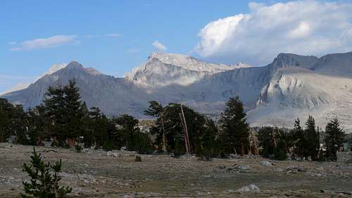 West face of Mt Hale (center) and the north face of Mt Young (far right) viewed from the Bighorn Plateau. The Northwest face of Mt Whitney looms immediately behind Mt Hale
Everything you need to know about permits, regulations, and driving directions can be found on the Eastern Sierra - Logistical Center page or the Whitneyzone.com site. Both the North Fork Lone Pine (NFLP) and the Main Whitney Trail (MWT) require day hiking and overnight permits.
Camping in the Mt Whitney drainage is limited to the following locations: Upper Boy Scout Lake (NFLP), Iceberg Lake (NFLP), the Arctic Lake basin (NFLP), Outpost Camp (MWT), and Trail Camp (MWT).
Climbing can be done in almost any season but May through October are the most popular times. In heavy snow years, the East slope, especially the chutes, may hold residual snow. This is also true for any of the routes over the Sierra Crest. Check for current weather.
External Links
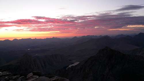 Mt Hale as seen from the summit of Mt Whitney at sunset. The summit is in the lower left with Hale's long northern escarpment seen stretching right to the center of the photo
2007 Sierra Challenge Day 9
Pictures:
My pics & TR
  |