Aerial Photos of Mount Rainier
![Rainier by Air]() Ranier summit, with Mt. Adams in the background. 8/6/2006
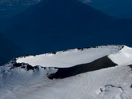
Ranier summit, with Mt. Adams in the background. 8/6/2006![Rainier Summit Cone]() The summit cone of Mount Rainier. You can see the trail crossing the cone, and the trail to the high point on the right. 8/6/2006
The summit cone of Mount Rainier. You can see the trail crossing the cone, and the trail to the high point on the right. 8/6/2006![Camp Muir on Rainier]() Camp Muir, Mount Rainier. You can see the trails leading away from the camp across the glacier in the upper right of the photo. 8/6/2006
Camp Muir, Mount Rainier. You can see the trails leading away from the camp across the glacier in the upper right of the photo. 8/6/2006![East Flank of Mount Rainier]() 8/6/2006
8/6/2006![Cowlitz Glacier of Mount Rainier]() Cowlitz Glacer in the center foreground. 8/6/2006
Cowlitz Glacer in the center foreground. 8/6/2006![Southeast Rainier]() Camp Muir is in the lower center of this photo. 8/6/2006
Camp Muir is in the lower center of this photo. 8/6/2006![Paradise, Mount Rainier]() Paradise is in the lower left of the photo. 8/6/2006
Paradise is in the lower left of the photo. 8/6/2006![Rainier Summit, from the South]() 8/6/2006
8/6/2006![Mount Rainier, Liberty Cap]() Liberty Cap, viewed from the west. 8/6/2006
Liberty Cap, viewed from the west. 8/6/2006![Mount Rainier West Flank]() 8/6/2006
8/6/2006![Kautz, Nisqually, and Ingraham Glaciers]() Kautz (center), Nisqually (near right), and Ingraham (far right) Glaciers. 8/6/2006
Kautz (center), Nisqually (near right), and Ingraham (far right) Glaciers. 8/6/2006![Emmons Glacier, Rainier]() Emmons Glacier, Russell Cliff on the right. Mount St. Helens is in the distance. 8/6/2006
Emmons Glacier, Russell Cliff on the right. Mount St. Helens is in the distance. 8/6/2006![Emmons Glacier]() Fresh snow slides on Emmons Glacier. 5/8/2009
Fresh snow slides on Emmons Glacier. 5/8/2009![Cowlitz Glacier, Rainier]() Cowlitz Glacier is in the center of the photo. 5/8/2009
Cowlitz Glacier is in the center of the photo. 5/8/2009![Rainier Summit, from the North]() 5/8/2009
5/8/2009![Rainier Summit]() Rainier Summit, from the East. You can see some of the trails going to the summit. 5/8/2009
Rainier Summit, from the East. You can see some of the trails going to the summit. 5/8/2009![Muir Snowfield and Cowlitz Glacier, Rainier]() Muir Snowfield and Cowlitz Glacier are near the center of the photo. 6/15/2004
Muir Snowfield and Cowlitz Glacier are near the center of the photo. 6/15/2004![Mount Rainier, Southeast Flank]() 6/15/2004
6/15/2004![Muir Snowfield, Mount Rainier]() You can see the trail ascending Muir Snowfield on the right, to Muir Camp in the upper right of the photo. 6/15/2004
You can see the trail ascending Muir Snowfield on the right, to Muir Camp in the upper right of the photo. 6/15/2004![Mount Rainier, from the South]() View from the South. 6/15/2004
View from the South. 6/15/2004![Mount Rainier, Southwest Flank]() 6/15/2004
6/15/2004Additional Photos
For additional Photos, go to
http://xpda.com/rainier/.
 The summit cone of Mount Rainier. You can see the trail crossing the cone, and the trail to the high point on the right. 8/6/2006
 Camp Muir, Mount Rainier. You can see the trails leading away from the camp across the glacier in the upper right of the photo. 8/6/2006
 You can see the trail ascending Muir Snowfield on the right, to Muir Camp in the upper right of the photo. 6/15/2004
Comments
Post a Comment