
|
|
Mountain/Rock |
|---|---|
|
|
41.81070°N / 115.3743°W |
|
|
Elko |
|
|
10838 ft / 3303 m |
|
|
This is to replace the page for this peak that was deleted when a SP member left SP and deleted all his work. Those who have signed the previous page's register hopefully will sign the register again and attach any pictures that may have been left floating when the original page was deleted.
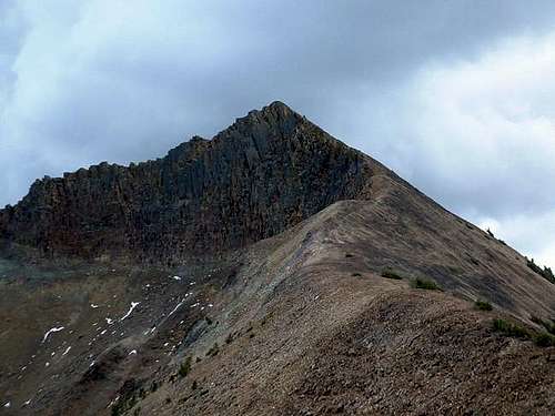
Dan Robbins pic of the north side
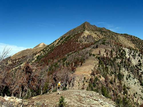
Ken heading for our goal.
Overview
The name Matterhorn brings to mind a beautiful mountain in Switzerland that has been at the heart and soul of mountaineering for the past 150 years. Is there a more beautiful mountain in the world than the Matterhorn? Probably not. However before I get too far along in this overview, I will state that the name of this mountain is indeed the Matterhorn BUT that is where the similarities end. It is a mountain peak in a range in the desert climate of the state of Nevada but this Matterhorn has its own charm although as one of the most isolated peaks in Nevada. Located in north central Nevada and only approachable by dirt roads that stretch for miles, this Matterhorn is
worth the effort since it is one of Nevada's top prominence peaks, coming in at number 15 on the top 100 list. Getting to the base of the peak is part of the adventure as you will see a part of Nevada that few others ever
see. A small hamlet called Jarbidge is nearby and it worth the visit in and of itself, even if you aren't interested in peakbagging.
The name "Jarbidge" originates from the Shoshone word "Jahabich," which means "devil." This was the Shoshone name for the nearby mountains which are known as the Jarbidge mountains (and contains Matterhorn peak)
Dan Robbins made this comment in his trip report on the town:
"The town of Jarbidge is tabbed as the "most remote inhabited town in the 48 contiguous states". No paved roads lead to the town and it is hours away from any cities large enough for say a McDonalds. Beyond its remoteness, it is tucked neatly in a very narrow river canyon. The remoteness, beauty, and history of the town all add up to make it an incredible destination. We ate a fine breakfast at one of the local eating establishments, which was very clean and modern.
To the southwest, the mighty Jarbidge Mountains rise 6,000 feet above the town. They really are nothing more than a high ridge of about 8 peaks above 10,000 feet that separate two forks of the Jarbidge River."
Matterhorn Peak is located within the boundaries of Jarbidge Wilderness area.

Entering Jarbidge
Getting There
Hopefully, the overview has whetted you interest a bit and now you'd like to know how to get there. Well, there are several ways and they all involve a long drive. Whether you go from Twin Falls or Elko, make certain to have a full tank of gas.
From Twin Falls Idaho or Jackpot Nv, head for Rogerson on US 93.At Rogerson, Idaho along US Route 93. Take the road west out of town, for Jarbidge.
After about ten miles the road narrows to a single lane as it crosses over a dam, and then resumes its normal width. At around 45 miles the pavement ends, you enter a canyon where the road descends and you will note the community of Murphy Hot Springs and stream to the left. At around 50 miles is a key junction. Turn left, noting "Jarbidge 13 miles". At a junction, stay left, and soon you will enter Nevada. Jarbidge community is at roughly 63 miles from Rogerson , and the speed limit is 10 m.p.h.
Go through town and head for the end of the road or as far as you can safely drive a 2WD vehicle. It takes high clearance and 4WD to get to the actual end of the road.
Adam Helman made these observations on getting to the end of the road:
"Continue through town. At the south end note the odometer and travel 1.7 more miles. Now re-zero the odometer. Distances below are in miles and coordinates use the WGS84 datum.
0.0 The road bears right over a concrete bridge (disregard the minor track lying straight ahead).
0.1 The road forks: right to Elko, left to the desired (new) trailhead.
(41.84550° N, 115.42886° W) at 6,692 feet.
0.9 Sign warns of a narrow, primitive road. Those with low clearance and/or 2WD should park at left on grass.
This is 1 mile short of the new trailhead, (41.83450° N, 115.42534° W) at 6,742 feet.
1.1 Sign warning of "ROAD HAZARD".
1.2 Two stream crossings; not recommended except with 4WD.
1.6 Third stream crossing.
1.9 New trailhead ("No motorized vehicles beyond this point").
(41.82248° N, 115.41564° W) at 6,680 feet.
Ken and I were able to make it to the end of the road in my high clearance Tacoma and one of the stream crossings would stop many from going further.
UPDATE: There was a stopper of a washout 0.4 mile from the end of the road.
We managed to park just short of it and it added 0.8 of a mile to
hike. If another vehicle is parked where we did, you will have to
back up a ways to find another place to park.
----------------------------
From Elko: See directions on the map picture

Elko to Jarbidge
Figure on over 80+ miles to get to road 745 at the Wild Horse Recreation area and another 50+ miles from there. About 135 miles from Elko to Jarbidge.
Great link with pics and info: "Get me to Jarbidge"
SP member famartin1 made the following comments regarding the route from Elko and I add them here:
famartin1 Better route if the snow is melted
"Taking the route which goes past Mt. Ichabod on the map (near bottom) is easier if the snow is all melted. Its in as good or better shape than the route you describe, is better signed (only two turns between NV-225 and Jarbidge, with both signed (though one poorly at present), and the scenery is pretty spectacular in wildflower season.
North on NV-225 to the first sign for Jarbidge (reads "Charleston 21, Jarbidge 47"). East on that road (it has a number but not signed so pointless to remember) to end at Charleston Reservoir, then north from there. The harder turn (by that I mean easier to miss) is just north of the ghost town of Charleston, which is presently barely signed with an old wood board."
This member also notes that the article presented in the link "Get me to Jarbidge" is the route described in the description above.
Red Tape
 New TH |
 Old TH |
 Ken |
Matterhorn Peak is located in the Jarbidge Wilderness area which is
administered by:
Humboldt-Toiyabe National Forest
1200 Franklin Way
Sparks, NV 89431
(775) 331-6444
FAX: (775) 355-5399
National Forest page link
Camping
Campgrounds:
There are several areas for free camping from Jarbidge to the end of Elko county road #2477. They are fairly primitive and are as follows:
Jarbidge
Pine Creek
Upper and Lower Bluster
Urdahl.
We saw outhouses at a few of these and we stayed the night at Urdahl which had picnic tables, fire rings and an outdoor vault toilet. Showers can be found for a fee at the Outdoor Inn in Jarbidge.
Services in nearby Jarbidge.
We did note gasoline availability but did not note the time it was available.
The Outdoor Inn did have food, drink and motel like facilities as well as the
hot shower availablility. The home made ice cream was excellent.
Views from the summit
 South |
 North |
 NE |
Routes
Our route was the Dry Gulch route. Many others will take the Snowslide Gulch route but since I only have experience with the Dry Gulch route, it will be presented on a map. Once you leave the trail after crossing Dry Gulch creek, there is no actual trail. You will need to determine the route up for yourself but we stayed on the ridgeline as much as possible as shown on the map. Total distance from the end of the road where we parked to the summit was about 4.3 miles with over 4000 feet of elevation gain.

Our route
----------------------------------------------------------------------
Adam Helman's Snowslide gulch route:
At the end of the driveable road:
Walk the road 1/4 mile to a blockade, (41.81966° N, 115.41363° W) at 6,773 feet. Find a footpath to the left (east) of the blocked road, and zigzag uphill along said path, one which soon heads south.
A stream crossing is encountered along the footpath after it descends into the main drainage. The coordinates are (41.81667° N, 115.41252° W) at 6,958 feet.
The former trailhead is soon reached with (41.81596° N, 115.41156° W) at 7,004 feet. Take the foot path south of the message board and left (east) of the horse path.
If your sole objective is the summit, I recommend avoiding the circuitous route described in summitpost (the Dry Gulch route). Rather, hike south until this point where a side drainage is encountered coming from the east. The coordinates are (41.80691° N, 115.40492° W) at 7,240 feet.
I bushwhacked steeply up the slope delimiting the drainage on its north, passing over spot elevation 9224 and reaching the main ridge north of Matterhorn. This route entails, among other aspects, 2000 feet of gain in one kilometer - roughly a 60% grade. There is much brush below 9,000 feet. To avoid it as much as possible, climb the talus instead wherever it is available.
As alternative I suggest climbing that ridge delimiting the drainage to its south. This concept has one approaching the summit from its south. Regardless, the top 100 or 150 vertical feet is steep talus - and looks like the "horn" from which the peak receives its name.
For those in a whiteout I obtain for the summit (41.81076° N, 115.37427° W) at 10,865 feet.
Net elevation gain from the new trailhead is 4,200 feet. The total gain is 50 feet more owing to small undulations in getting from the new to the old trailhead. In addition my route entails 100 more feet for descending / reascending hill 9224 - making for a 4,350 foot total elevation gain.
Allow 6 to 10 hours for the round-trip depending on your fitness level.

Via Snowslide Gulch ridge
Weather


A bit about Jarbidge
As Nevada mining towns go, Jarbidge was a late-comer. It wasn't until October, 1909 that gold was found in the region, a year after many Nevada boomtowns went sour due to the Panic of 1907, when capital forthcoming to finance Nevada mining went instead to rebuilding San Francisco after the 1906 earthquake.
Thanks to4wd trips.net for providing the following:

By early spring of 1910 Jarbidge started growing swiftly even though the region was thoroughly buried in deep snows, partly fueled by embellished newspaper accounts and rumors. By May, many started leaving Jarbidge en masse. Those who stuck it out until the snow melted did indeed find gold bearing ledges and Jarbidge started building. Jarbidge continued with a seasonal boom/bust cycle until 1918 until the Elkoro Mining Company bought up principal claims and year round production ensued until the Depression.
Jarbidge does have a first and last in its history – the last stagecoach robbery with resulting murder of the stage driver lead to the first use of palm and fingerprints in forensic science to catch and convict the killer. In December, 1916, the Idaho stage was held up by a gunman who killed the stage driver and made off with the mail and $3,000 in cash. He propped up the dead man's body in the seat, smearing his hands with the blood of his victim while doing so. The murderer then washed his hands in the river, then went about the task of opening mail, carelessly scattering the envelopes. He was soon caught and later convicted, based upon his fingerprints and palm prints left upon the envelopes.
The Shovel Brigade
Click HERE to read about this important piece of Jarbidge history
Mother Jones link to a story on the Shovel Brigade.
Links to videos
Magic Valley Newspaper Article
Posted by
Mike Cothern - Times-News correspondent Magicvalley.com | Posted: Thursday, October 22, 2009 Link
"Many unique qualities define northern Nevada's picturesque Jarbidge Mountains. The short 10-mile range spans the boundary of two of the West's major drainages: one section serves as the Columbia Basin's highest point south of the Snake River; the opposite end spawns flows that enter into but never escape the Great Basin.
The area's geographic isolation also plays an important role in backcountry recreation. Nancy Paylor, recreation specialist for the Jarbidge Ranger District, says the Jarbidge Wilderness receives fewer visitors than almost any wilderness area in the lower 48 states, making it an excellent choice for those seeking a quiet, remote experience.
"Monitoring equipment at the Mahoney Guard Station records the best air quality in the nation," Paylor says.
Continuing on in his article, he talks about doing the loop hike described in Ken Grubbs book, Hiking Nevada, and then mentions the Matterhorn:
"The Matterhorn, the next peak climbed, easily became the highlight of the trip. Named after the famous Swiss Alp, the Jarbidge Mountains' tallest point easily possessed the steepest approach. The route was also obstacle-laden with whitebark pines often crowding the west slope and inaccessible cliffs marking the east. In addition, the summit surprised us with a dizzying drop-off on the unclimbed side, sending us scurrying back to a more secure spot. While catching our breath we signed the register and read from the 10 entries recorded for the year."
Read all of his trip report HERE.
In case you missed the link earlier in this page, Dan Robbins has a great trip report posted on his website of Idaho summits. Here's the link.
Disclaimer
Hiking, climbing or traveling in this type of country can be inherently dangerous, the above information is provided only as a courtesy. You accept all risk and responsibility for your activities in this area and I recommend that you let others know of your plans and where you will be hiking/climbing prior to heading to this area. Be self sufficient and carry plenty of food, water and shelter in the event of a breakdown. Good quality tires are a necessity on the rough and rocky roads you will encounter as is a vehicle in good condition. Roads may become impassable when wet. Avoid the area during electrical storms and avoid high ridges &exposed areas. Having said all that, have a good trip and please let the author of this page know of changes that you encounter.
Please let me know if road conditions or access changes.
utahjimk - Jul 16, 2013 11:25 am - Voted 10/10
route clarification"Snowside" and "Snowyside" should be "Snowslide" according to USGS topo
Dean - Jul 16, 2013 11:45 am - Hasn't voted
Re: route clarificationThanks Jim, I sure missed that. It is now corrected. : )