Overview and Routes
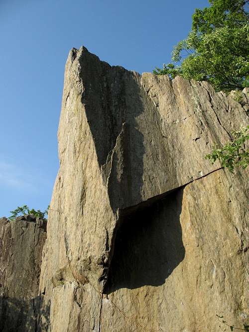
![The Nose (5.12)]() The Nose
The Nose![Lost Arrow (5.10) and The Strain (5.13)]() The hardest climbs at Great Falls?
The hardest climbs at Great Falls?
Perhaps the most striking of the named Great Falls climbing crags, Aid Box is one of the hardest climbing spots in the park, with the easiest established routes beginning at 5.5 and the hardest getting up to 5.13.
The crag itself is distinguished by its prominent "nose" that is best seen and appreciated from below and just upstream of the crag, though it is noticeable from the River Trail above, which helps hikers and climbers find this spot. Aid Box is a small amphitheater that faces the river but is not directly over it, so if you fall, you can break your bones on the hard rock instead of drowning in the treacherous Potomac River.
Toproping is the climbing style most common at Great Falls. Most routes really aren't suitable for leading, especially considering the ban on fixing permanent bolts, but some routes can be led (and are). At Aid Box, it is recommended that you bring equipment for setting up a toprope; although I've never met others here on my visits, the crag is supposedly one of the most popular at Great Falls, and the best natural setups may be taken by the time you arrive.
The climbs here only range from 25 to 40 feet, and most have just a single pitch, but they are hard. SP's best climbers would probably like this area the most of the Great Falls climbing crags I have put up on the site thus far.
All the photos on this page have captions that provide useful directional or route information. Please click on them to access that information.
If you have climbed or do climb any of the routes listed on this page, or any that aren’t, please add a route page or supply an overview in Additions (I will add it to the main page).
A selection of the established routes on Aid Box, from upstream to downstream:
• P.V. Wall (5.12a/b)—about 10 feet right of the overhang on the upstream face, climb the face (not the crack to the right).
• P.V.O. (5.12b/c)—Potomac Valley Overhang. On the upstream face, climb a thin crack that takes you under the left side of the overhang. Then pull through that left side with what guidebook author Eric Horst calls “body-wrenching moves” and finish straight up.
• The Strain (5.12c)—Begin on either P.V.O. or Lost Arrow to access the incipient crack running vertically between them. Then head up.
• Lost Arrow (5.10c)—a pin-scarred crack and a left-facing corner finish just left of the “nose.” Area classic. People will sit around and wait for this one.
• Splinters (5.7)—starts below a small overhang, goes along the right-facing corner.
• The Box (5.5)—a large, right-facing corner near the middle of the Aid Box wall; might be suitable for good free soloists, but getting up into the corner itself is very tricky.
• Diagonal (5.9-)—climb the first 15 feet of The Box, which takes you to the base of the corner, and then follow the diagonally running crack along the left wall.
• Monkey Fingers (5.12a/b)—Start about 15 feet left of the corner of The Box and climb the “thin, desperate crack.”
• Dark Corner (5.6)—an obvious corner about 15 feet left of Monkey Fingers.
• Skid Row (5.9)—About 5 feet left of Dark Corner’s namesake, on an upstream-facing wall, climb up a few feet and then move left in the direction of the edge and follow a crack and flake.
Many of these routes are listed in the local guidebook as being among the best Great Falls has to offer.
•Scrambling—not much on the crag itself, but some. Near the left end, below the upstream-facing wall, look for a narrow ramp offering an easy way around to the river-facing side. Break out on a shelf with a nice view of the river and the cliffs across it. The scrambling opportunities on Aid Box proper are here. To the left, they are easier and Class 3. To the right, they get into Class 4. One of them, pictured in this page's gallery, leads to the top of one of Aid Box’s pinnacles and provides a spectacular view upstream of the “nose,” Little Aid Box, and the Romeo’s Ladder/Seclusion area.
Getting There
From the western part of I-495, a piece of the Capital Beltway, take Exit 44 for Route 193, Georgetown Pike; this is the second exit south of the Maryland border. Drive west for a few miles until you see the well-signed road leading to Great Falls Park. Turn right and follow the road about a mile to the entrance station. There are two large parking lots after the entrance station, but make an immediate right instead to reach the "lower lot."
To reach the crag, hike to the River Trail, the last maintained trail before the river. After passing the Sandbox and Dihedrals access points, the trail drops down some wooden steps, makes a bridged stream crossing, and then climbs a set of wooden steps. At the top of the climb, the trail splits in three, with the River Trail heading right. Follow the River Trail across some wooden planks. Shortly after them, you will come to an eroded area that has a nice view of the upstream end of Seclusion (with the Seclusion route). It’s about 40 more yards to the top of that crag. Continue hiking until you see the Romeo's Ladder route on an upstream-facing wall. Keep hiking for maybe another 30-40 yards until there is easy Class 2/3 access to the river. At the river, turn around and look back at the cliffs. Aid Box is to your left. Look for the prominent "nose" to make sure you're there.
It should take around 15 minutes to hike from the parking area to the base of Aid Box.
![The Nose]() The Nose
The NoseRed Tape
The park is open from 7 A.M. until dark every day except Christmas. There is an admission fee, good for three days, of $5 per vehicle or $3 per person entering on foot or by bicycle. Annual and interagency passes are also available (the latter costs $80).
Climbers are required to register (free). There is a registration box at the climbers’ parking area, and there is also one at the visitor center.
Drilling to place bolts is prohibited. If you use chalk, try to use colors that blend with the rock here.
The area is popular and can be quite crowded, especially on weekends spring through fall, and this crag is among the most popular.
The park is home to copperheads. It’s unlikely that they hang out in holds on the cliffs themselves, but be aware. The danger, though slim, is greatest near the clifftops, where there are more places for snakes to be.
Poison ivy is abundant. The humid period from late spring through early fall features gnats, mosquitoes, and other biting insects.
Camping
None
External Links
Great Falls NPS site
A good resource for the area is Eric Horst’s
Rock Climbing Virginia, West Virginia, and Maryland. The section on Great Falls provides one-sentence overviews of the routes. There are also photos, taken either from a boat or from the Maryland side, of the crags, and the photos have useful diagrams showing the locations and directions of the routes. The guide leaves the step-by-step concerns, and the fun, to you.
An even better resource is the
PATC Climbers' Guide, which focuses just on the Great Falls area. It lists more crags and routes than the other guide does, and the photos are usually better in terms of helpfulness with finding the routes.

 11107 Hits
 81.17% Score
 13 Votes
 The Nose
 The hardest climbs at Great Falls?
 The Nose