
-
 4766 Hits
-
 79.04% Score
-
 10 Votes
|
|
Mountain/Rock |
|---|---|
|
|
38.99070°N / 77.2485°W |
|
|
Trad Climbing, Toprope, Scrambling |
|
|
Spring, Summer, Fall, Winter |
|
|
129 ft / 39 m |
|
|
Overview and Getting There

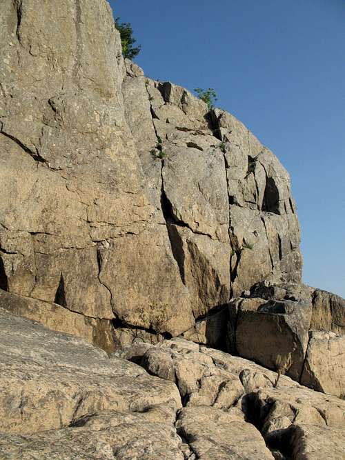
Upstream-facing wall

Upstream-facing Wall
Little Aid Box is a small crag detached from and just upstream of the harder, more popular, and more spectacular Aid Box. Its routes are unnamed and few people climb here, which makes it perfect for scramblers and roped climbers alike who seek something in the 5.4-5.8 range and don't mind that the climbs are only about 25-30 feet in length.
Starting from the downstream end, you will find the following climbing opportunities (some are visible in the primary image):
A 5.5 crack.
A 5.8 river-facing wall.
A 5.6 corner.
A narrow 5.8 face looking downstream.
A 5.4 river-facing wall (look for three old iron rings on the wall and start from there; see attached photos for more details).
A 5.5-5.6 upstream-facing wall just around the corner from the iron rings.
I have climbed from the rings and on the upstream-facing wall and can attest that although they are short climbs, they are fun and definitely worth doing, especially if you are climbing without rope.
Most roped climbing at Great Falls is done by toproping. At this crag, bring gear or very long anchors for setting up the toprope.
Altering the rock to place gear is prohibited. Do not remove or replace existing bolts. The general rule here is that if you can't lead using natural gear, you should toprope just as most others do. If you use chalk, try to use "White Courage," the standard accepted by the Great Falls climbing community.
GETTING THERE: From the western part of I-495, a piece of the Capital Beltway, take Exit 44 for Route 193, Georgetown Pike; this is the second exit south of the Maryland border. Drive west for a few miles until you see the well-signed road leading to Great Falls Park. Turn right and follow the road about a mile to the entrance station. Take an immediate right to reach the "lower lot."
Hike to the River Trail, the last trail before the river. After passing the Sandbox and Dihedrals access points (there are signs indicating them), the trail drops down some wooden steps, makes a bridged stream crossing, and then climbs a set of wooden steps. At the top of the climb, the trail splits in three, with the River Trail heading right. Follow the River Trail across some wooden planks. Shortly after them, you will come to an eroded area that has a nice view of the upstream end of Seclusion (with the Seclusion route). It’s about 40 more yards to the top of that crag. Continue hiking for maybe another 50 yards until there is easy Class 2/3 access to the river. At the river, turn around and look back at the cliffs. Aid Box is to your left. Little Aid Box is upstream and to your right.
It should take around 15 minutes to hike from the parking area to the base of Little Aid Box.
"Rings" Face
Red Tape
The park is open from 7 A.M. until dark every day except Christmas. There is an admission fee, good for three days, of $5 per vehicle or $3 per person entering on foot or by bicycle. Annual and interagency passes are also available (the latter costs $80).Climbers are required to register (free). There is a registration box at the climbers’ parking area, and there is also one at the visitor center.
Altering the rock to place gear is prohibited. Do not replace existing bolts. The general rule here is that if you can't lead using natural gear, you should toprope just as most others do.
The area is popular and can be quite crowded, but people rarely climb at this crag.
The park is home to copperheads. It’s unlikely that they hang out in holds on the cliffs themselves, but be aware. The danger, though slim, is greatest near the clifftops, where there are more places for snakes to be.
Poison ivy is abundant. The humid period from late spring through early fall features gnats, mosquitoes, and other biting insects.
Camping
NoneExternal Links
Great Falls NPS siteA good resource for the area is Eric Horst’s Rock Climbing Virginia, West Virginia, and Maryland. The section on Great Falls provides one-sentence overviews of the routes. There are also photos, taken either from a boat or from the Maryland side, of the crags, and the photos have useful diagrams showing the locations and directions of the routes. The guide leaves the step-by-step concerns, and the fun, to you.
An even better resource is the PATC Climbers' Guide, which focuses just on the Great Falls area. It lists more crags and routes than the other guide does, and the photos are usually better in terms of helpfulness with finding the routes.