
-
 7702 Hits
-
 83.1% Score
-
 16 Votes
|
|
Mountain/Rock |
|---|---|
|
|
38.98720°N / 77.2462°W |
|
|
Trad Climbing, Toprope, Scrambling |
|
|
Spring, Summer, Fall, Winter |
|
|
150 ft / 46 m |
|
|
Overview
It took the Greeks 10 years to figure out a way inside the great wall around Troy, and it could feel that long by the time you find a good way through THIS Trojan wall down to its base, from which there are several more nice options for breaching it. At the top, you likely will not find a face that could launch a thousand ships and are more likely to find a sweaty hiker instead, but this crag has some nice things going for it:
• The difficulty accessing it means that you’ll probably have it to yourself even though the Great Falls area is highly popular with rock climbers.
• The routes are in the intermediate range, making them fun for just about anyone (anyone who climbs, that is).
• There is a great option here for free soloists who like an adrenaline rush and a challenge but who aren’t good or crazy enough to free solo routes on which most very skilled climbers would rope up.
• It’s an awesome location, rising pretty much straight from the river. In fact, except when water levels are low, the climbs here will be inaccessible except by rappelling down to their bases.
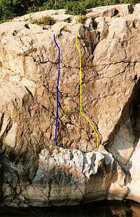
The routes range from 40-70’ in vertical climb. Upstream to downstream, they are as follows (see photos for route diagrams and other information):
• Paris (5.8)
• Helen (5.7)
• Troy (5.7)
• Trojan Horse—Halfway up the corner on Troy, a crack on the overhanging left wall presents itself. That’s the way.
• Odyssey (5.2-5.4)—Many possibilities on this wall. Great fun for unroped climbers-- try a few different ways.
I find it strange that there's a route called Odyssey and not one called Iliad, considering that the Trojan Wall is such a powerful, albeit inanimate, force throughout the Iliad. But it's in the Odyssey that the Greeks finally get inside the city of Troy, so maybe that's the explanation. Or maybe one just shouldn't apply too much literary analysis to names of climbing routes.
Approach: The Trojan Wall is located on Bear Island in the C&O Canal National Historical Park. Bear Island is an ecologically sensitive area as it is home to several rare plant and animal species that have few other places to live in this overdeveloped region, so please stay on the trails and rocks as much as possible. When descending to the base of the crag, look for areas that show signs of use and utilize them until you reach the bare rock ledges of the cliffs.
From the top of the crag (see directions in Getting There), hike a few yards downstream and then start looking for a reasonable way down. You will encounter at least Class 4 climbing and possibly harder. Do not fall for the easy way down to a sandy beach; this is too far downstream, and there is no way to get to the crag from here unless you just happened to have caried a boat with you.
NOTE: When water levels aren't low, this crag will be impossible to access except by rappelling down.
Climbing Styles: Most climbers at Great Falls, even the experts, employ toproping because of the abundance of natural anchors, the top-to-bottom approaches, and the slick rock that has been known to spit protection out. The routes are not bolted, and it is illegal to place new bolts or alter the rock in any other way.

Getting There
To reach C&O Canal NHP, where the Maryland Great Falls Crags are: From I-495, take Exit 41, just north of the Virginia line, heading west on the Clara Barton Parkway and then onto MacArthur Boulevard. MacArthur leads directly to the park entrance at Great Falls Tavern.Hike south to the Billy Goat Trail and turn onto it. From the parking area, the Trojan Wall is about a mile away, but the hike there feels longer because the trail is so rocky. The crags out here aren't signed as some on the Virginia side are, so look for two indicators of the Trojan Wall's location. The first is the view pictured in this section. If you are on an open clifftop high above the river and looking directly across at the view shown here, you are atop the Trojan Wall. The second indicator is a trail marker marked just as Marker #1 (does not indicate distance). The top of the crag is a few yards past this sign (or before it, if you're taking the approach described below).
Alternately, avoid the entrance fee and much of the crowds by parking at Old Anglers Inn (off MacArthur Blvd.) and pick up the Billy Goat Trail from there.
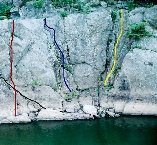 When you have this exact view, you are atop the Trojan Wall.
Red Tape
The park is open from 7 A.M. until dark. There is an admission fee, good for three days, of $5 per vehicle or $3 per person entering on foot or by bicycle. Annual passes and the America the Beautiful Pass ($80 for the latter) are also available.The park is home to copperheads. It’s unlikely that they hang out in holds on cliffs, but be aware. The danger, though slim, is greatest near the clifftops, especially those near trees, where there are more places for snakes to be.
Watch for poison ivy, especially on the descent.
Camping
NoneExternal Links
Consider getting the PATC Climbers' Guide. It focuses just on the Great Falls area and details numerous crags and routes, including the Trojan Wall.C&O Canal NPS site