
-
 36856 Hits
-
 84.27% Score
-
 18 Votes
|
|
Mountain/Rock |
|---|---|
|
|
49.65006°N / 125.22406°W |
|
|
Hiking, Ice Climbing, Skiing |
|
|
Spring, Summer, Fall, Winter |
|
|
4560 ft / 1390 m |
|
|
Overview
 Mt Becher from Mt Drabble Mt Becher from Mt Drabble |
Mt Becher is a gentle domed summit found in the extreme southeast corner of Strathcona Provincial Park, British Columbia, Canada. Although not exactly extreme terrain in the middle of nowhere, Becher is a very popular destination with Vancouver Islanders in summer and winter alike.
Generations of neophyte backcountry skiers have cut their teeth on the largely forgiving route the summit. A superb circle hike is possible on foot or skis to the summit, along Boston Ridge and back to the start point. And finally, in most seasons, there is excellent ice climbing in the cirque above Boston Lake almost directly below the summit.
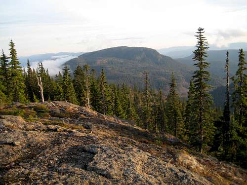
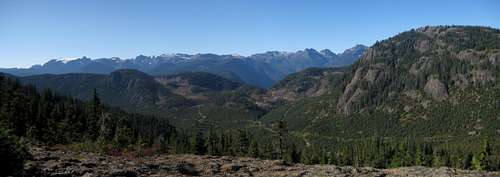
From the summit, or the routes to it, there are good views northeast over Forbidden Plateau and south to Comox Lake and Georgia Strait and the northern Gulf Islands. Potentially the best views are southwest to northwest, to the chain of mountains running from the Comox Glacier to Mt Albert Edward. Unfortunately, trees obscure much of this aspect.
The summit area is expansive and quite flat. There are numerous cairns marking possible high points. My bet in the lottery for the true summit is at N49° 39.028 W125° 13.458.
Getting There
Mt Becher can be approached from the Courtenay area to the east via the old abandoned Wood Mountain ski operation or from Cumberland and Comox Lake to the south on a series of steep logging roads.
For the Wood Mountain route, approach on Highway 19, turn off at the Piercy Road exit (# 127) and drive ~ 1km towards Courtenay. Turn right onto Forbidden Plateau Rd. Drive back over the highway and proceed ~ 15km up to the remains of the old Forbidden Plateau ski lodge. The first 7-8 km of the road is paved and the rest is reasonable gravel. Don’t get confused with the Paradise Meadows approach to Forbidden Plateau via Strathcona Parkway (as in the approach to Mt Albert Edward for example). Although Paradise Meadows does give access to what everyone takes to be Forbidden Plateau, the old ski operation on Wood Mountain used the title “Forbidden Plateau” for years and the local authority used, and kept, that name for road up to it.
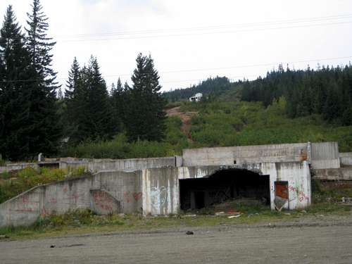 Remains of the old ski Operation Remains of the old ski Operation |
 Boston Ridge/Mt Becher Trailhead Boston Ridge/Mt Becher Trailhead |
 Road 23 Approach Road 23 Approach |
Comox Lake Main is the main arterial feeder for active logging in the area by Timberwest Ltd and is formally closed to the public 7 days a week during the hours 6 am to 6 pm UNLESS you are carrying a licensed VHF radio to communicate with the logging traffic. This rule is not always enforced but a gatekeeper MAY be stationed on the road shortly after it becomes gravel. If he’s on duty he will check to see if you have a radio and will turn you away if you don’t. In the window 6 pm-6 am there are no restrictions. Travel on this route, therefore, may require an evening approach or knowledge of the use of VHF radios.
Assuming one or the other, drive along Comox Lake for ~ 10.5 km from the Bevan/CLM junction and find Pearce Creek Road on the right. Drive up the Pearce Creek valley. There are lots of roads in this heavily logged area. Stay on the main line when presented with a choice but if in doubt keep right. You are aiming for the top of “Road 23” at N49 39.807 W125 14.135 – about 7.5 km driving distance from CLM in the head of the Pearce Creek valley with Mt Becher to the right and Indianhead Mountain on the left.
For the Wood Mountain approach there is some gravel road involved in getting to the access point but, generally, a normal 2WD sedan is fine. For the Comox Lake approach the roads are steep and rough and a 4WD vehicle with high clearance would be well advised.
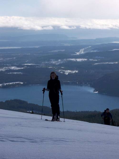 Skiing up to the summit of Mt Becher
Summit Routes
1. From Wood Mountain
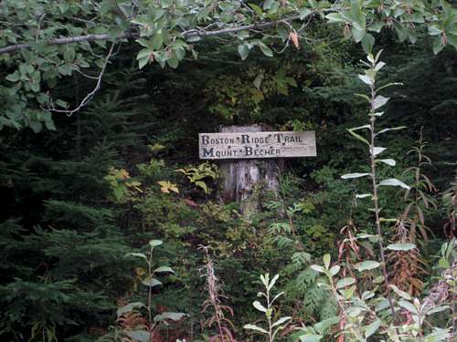
The summit can be approached on foot, skis or snowshoes at any time of the year via the old ski hill or Boston Ridge.From the Boston Ridge trailhead on Forbidden Plateau Rd walk south on the trail for approximately 800-900 metres. Cross the river and continue west up through the forest onto Boston Ridge. Cross an old logging road right on the ridge crest about 2 hours from the car and go up to a high point from there. Drop into a sharp saddle and then turn northwest up to the broad summit dome. About 2-3 hours from the car.
 Skiing up from the old lodge Skiing up from the old lodge |
 Comox Glacier and Rees Ridge Comox Glacier and Rees Ridge |
 Boston Lake overlook Boston Lake overlook |
 Mt Becher trail junction sign Mt Becher trail junction sign |
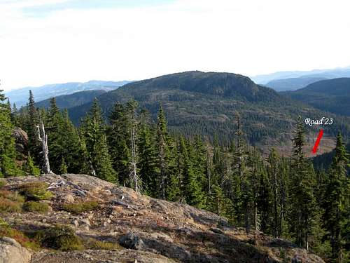
2. From “Road 23”
From the road end walk north on well flagged trail through a little logging slash and into the trees. After ~5 minutes – about 250 metres – you reach a trail junction signed with red markers by local enthusiasts. Take the right fork for Mt Becher.The initial part of the track is well marked with flagging and red discs on trees as far as Ash Pond where it breaks out into the open on the west side of Becher and the first views appear. Views to the west from here are amongst the best on the mountain.
 Mt Becher from the NW Slopes Mt Becher from the NW Slopes |
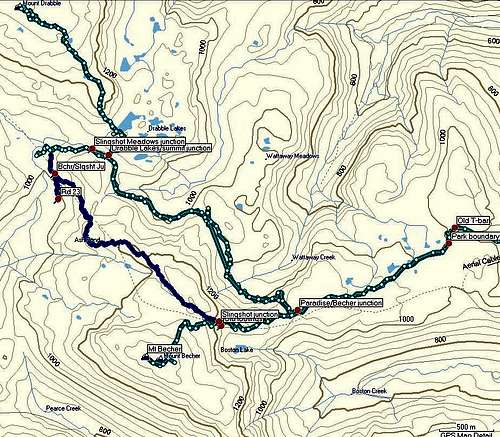 Mt Becher Routes Overview Mt Becher Routes Overview |
About 20-30 minutes after Ash Pond the track re-enters the bush and skirts the north side of a minor gorge before breaking out once more onto open ground to the north of the summit. It then reaches a high point of 1,280 metres before descending steeply to join the main route up the mountain at N49 39.199 W125 12.899 at almost exactly the site of the old Mt Becher ski cabin that was burned down in 1985. The footings can still be seen just off the main track.
Thereafter simply follow the main track up to the summit in about 30 minutes - a total of about 2-2.5 hours from the car at the end of Road 23.
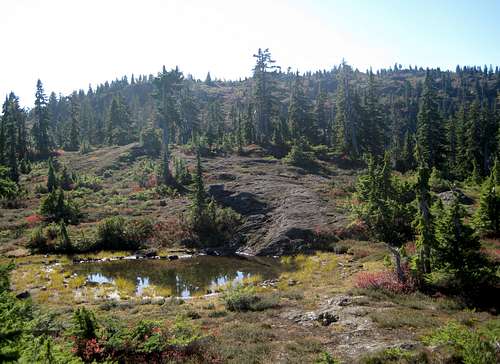
 View from Ash Pond View from Ash Pond |
Descend by reversing your routes or link various tracks together via the Mt Drabble approach as shown in the accompanying tracklog.
A GPS-ready MapSource/Garmin tracklog is available for the asking for the approach and summit routes. Just send me an email or PM.
Summary of Winter Routes
Approached from the old ski area. From the top of the runs follow the above directions to the base of the last ridge up to the summit where there is a flat bench and lookout over Boston Lake. Traverse left (southeast) and down into the cirque below the summit.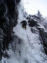
Boston Falls; WI4, 125 metres
Waterboys; WI2/3, 75 metres
Stranglers Tea Party; WI3, 100 metres
Shrapnel Chute; WI3, 150 metres
Refer to the Island Alpine guidebook – see “Useful Links” below.
Red Tape
None.Camping
Almost everyone going in to Mt Becher for any of the activities described above does so as a day trip. However, if you do want to camp, there are no restrictions or fees. Just remember to practise your best no-trace methods, boil or otherwise treat your water and light no fires.Useful Links
Beyond Nootka – A Historical Perspective of Vancouver Island Mountains, Lindsay Elms, Misthorn Press, 1996, ISBN 0-919537-29-4For route information refer to Island Alpine – A Guide to The Mountains of Strathcona Park and Vancouver Island, Philip Stone, Wild Isle Publications, 2003, ISBN 0-9680766-5-3
If ice climbing is your main area of interest visit SP member Stickit’s Vancouver Island Ice page
A good resource for backroad maps of the Island is the Backroad Mapbook. Volume III: Vancouver Island
Weather and snow conditions
As for any winter trip on the Island check Vancouver Island Avalanche Conditions before you leave.
Nearest point current conditions and forecast.
OR
Check the weather at altitude right from Mt Washington’s webcam
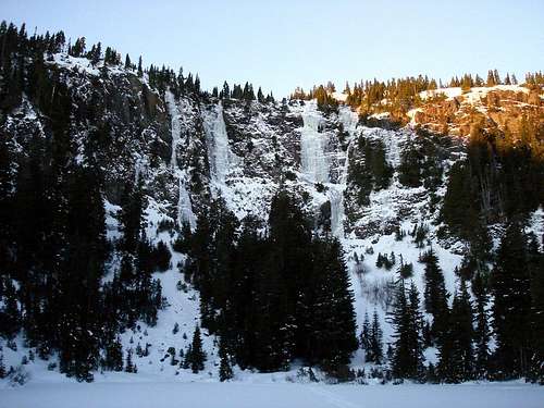 Mt Becher on the right above Boston Falls. Photo by johnrw