
-
 20242 Hits
-
 83.1% Score
-
 16 Votes
|
|
Mountain/Rock |
|---|---|
|
|
49.68000°N / 125.241°W |
|
|
Hiking |
|
|
Spring, Summer, Fall |
|
|
4472 ft / 1363 m |
|
|
Overview
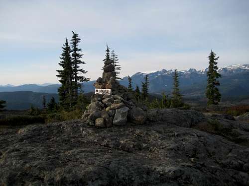 Mt Drabble summit Mt Drabble summit |
The shortest route into Mt Drabble approaches from Comox Lake to the south. For those wanting a longer hike, BC Parks excellent through trail from the old ski area on Wood Mountain to Kwai Lake in the Paradise Meadows area of the park can be used to approach the mountain to within 1.5 km. Thereafter, a well-flagged and cairned route leads to the summit with a little scrambling in a few places.
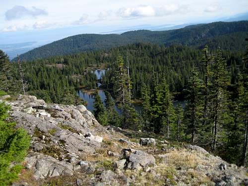
The main reason to visit Drabble is for the views. Unlike nearby Mt Becher, the summit area is relatively open and offers superb and uninterrupted views from the southwest to northwest across to the chain of mountains extending from the Comox Glacier to Mt Albert Edward and beyond. An odd trick of the topography even allows a glimpse of the distinctive outline of Victoria and Warden Peaks 75 km to the northwest. East of Drabble and its near neighbours the land drops quickly to the flatlands of the east coast of the Island and there is, therefore, no impediment to the view right across the Strait of Georgia to the Coast Mountains on the mainland.
The summit area is a superb place to camp with lots of sheltered flat spots and numerous tarns for water. A night on the summit, of course, allows for lots for photographic opportunities in different light conditions.
Mt Drabble is named for George Drabble, an early surveyor and pioneer in the area.
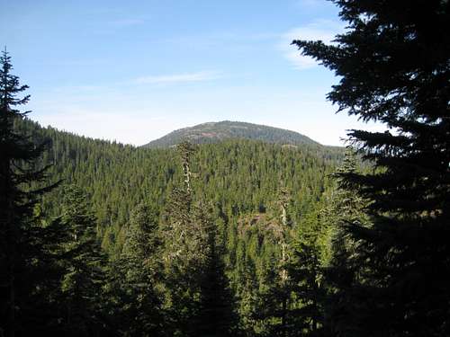 Mt Drabble from the approach trail Mt Drabble from the approach trail | 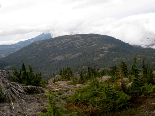 Mt Drabble from Mt Becher Mt Drabble from Mt Becher |
Getting There
Vancouver Island can be reached directly by air from Toronto, Vancouver, Seattle, Calgary, Edmonton and recently from San Francisco to either Victoria, Nanaimo, Comox or Campbell River and by ferry from Port Angeles to Victoria on The Coho and on BC Ferries from Vancouver to Victoria or Nanaimo. Public transport on the Island is notoriously poor and anyone arriving by air would be advised to rent a vehicle appropriate to the demands of the approach.Mt Drabble can be approached from the Courtenay area to the east via the old abandoned Wood Mountain ski operation or from Cumberland and Comox Lake to the south on a series of steep logging roads.
For the Wood Mountain route, approach on Highway 19, turn off at the Piercy Road exit (# 127) and drive ~ 1km towards Courtenay. Turn right onto Forbidden Plateau Rd. Drive back over the highway and proceed ~ 15km up to the remains of the old Forbidden Plateau ski lodge. The first 7-8 km of the road is paved and the rest is reasonable gravel. Don’t get confused with the Paradise Meadows approach to Forbidden Plateau via Strathcona Parkway (as in the approach to Mt Albert Edward for example). Although Paradise Meadows does give access to what everyone takes to be Forbidden Plateau, the old ski operation on Wood Mountain used the title “Forbidden Plateau” for years and the local authority used, and kept, that name for road up to it.
For the south approach, from Highway 19 take the Comox Valley Parkway/Cumberland exit (#117) and turn west towards the latter. After ~ 1.5 km turn right at the Save-on-Gas station onto Bevan Road. Drive 5.5 km on gravel to the junction of Bevan and Comox Lake Main (CLM) and turn left. Note the location of this junction for your return journey. It isn’t signed at the Comox Lake end. CLM is paved for the first km or so but soon reverts to gravel.
Comox Lake Main is the main arterial feeder for active logging in the area by Timberwest Ltd and is formally closed to the public 7 days a week during the hours 6 am to 6 pm UNLESS you are carrying a licensed VHF radio to communicate with the logging traffic. This rule is not always enforced but a gatekeeper MAY be stationed on the road shortly after it becomes gravel. If he’s on duty he will check to see if you have a radio and will turn you away if you don’t. In the window 6 pm-6 am there are no restrictions. Travel on this route, therefore, may require an evening approach or knowledge of the use of VHF radios.
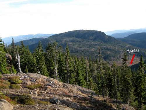
Assuming one or the other, drive along Comox Lake for ~ 10.5 km from the Bevan/CLM junction and find Pearce Creek Road on the right. Drive up the Pearce Creek valley. There are lots of roads in this heavily logged area. Stay on the main line when presented with a choice but if in doubt keep right. You are aiming for the top of “Road 23” at N49 39.807 W125 14.135 – about 7.5 km driving distance from CLM in the head of the Pearce Creek valley with Mt Becher to the right and Indianhead Mountain on the left.
For the Wood Mountain approach there is some gravel road involved in getting to the access point but, generally, a normal 2WD sedan is fine. For the Comox Lake approach the roads are steep and rough and a 4WD vehicle with high clearance would be well advised.
Routes
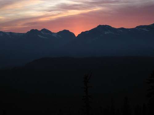
Eric/Ralph pass at sunset
1. From Wood Mountain
From the remains of the old ski lodge walk up the overgrown runs keeping to the obvious well-worn ATV tracks whenever you are faced with a choice. Just past the lower station of the old high level T-bar the route levels out, turns southwest and almost immediately arrives at the Strathcona boundary sign.
About 1.5-2 hours from the start the route arrives at a well-signed junction at N49° 39.255 W125° 12.293 for the spur route to the summit of Mt Becher. Turn right and proceed in the direction labelled “Plateau Trail”. This trail takes the hiker eventually all the way through to Kwai Lake (about 20km) and Paradise Meadows.
The trail meanders across the lower northeast slopes of Mt Becher, descending and climbing on several occasions, before reaching an open, swampy meadow and a signed track junction for “Drabble Lakes” in about an hour from the Mt Becher junction at N49° 40.025 W125° 13.747.
Turn right and reach the first of the Drabble Lakes in 5-10 minutes from the junction.
 Drabble Lakes | 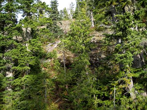 Bluffs on Mt Drabble | 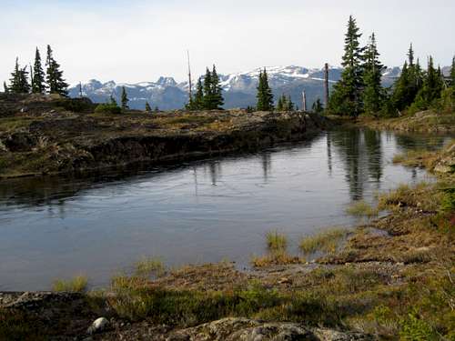 Mt Drabble Summit Plateau | 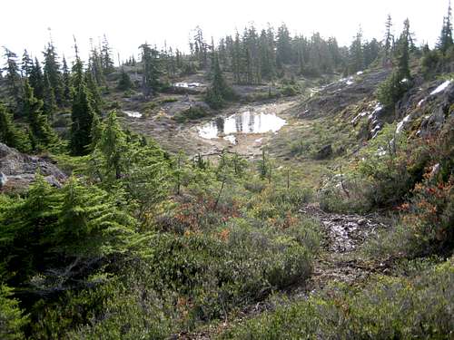 Mt Drabble Summit Plateau | 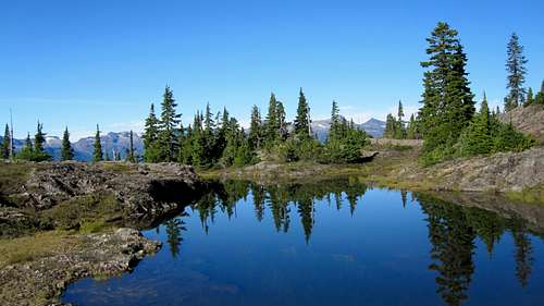 Mt Drabble Summit Plateau |
Above the second lake the route is mostly open and you can see where you have to go. There are at least 2 steep sections where a little scrambling is required.
With a full camping pack, allow 1-1.5 hours from the Drabble Lakes junction and 3-5 hours from the car.
2. From “Road 23”
From the road end walk north on well flagged trail through a little logging slash and into the trees. After ~5 minutes – about 250 metres – you reach a trail junction signed with red markers by local enthusiasts. The right fork goes up and over neighbouring Mt Becher. Instead, take the left fork and walk up to open area known as Slingshot Meadows in another 5-10 minutes.
From the open meadow walk north until you find cairns and/or flagging and follow the markers east to a very prominent junction at N49 40.058 W125 13.873 with one of the original wooden CDMC Forbidden Plateau trail signs. Turn right here and reach the “Drabble Lakes” junction sign as noted in the Wood Mountain approach in just 2-3 minutes.
From the end of Road 23 it’s no more than 30 minutes to the Drabble Lakes junction and an hour or so from the summit from there as described above.
 Mt Drabble S Approach Road | 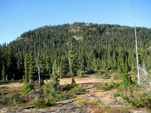 Slingshot Meadows | 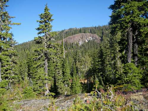 Mt Drabble from Slingshot Meadows | 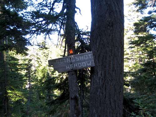 Slingshot Meadows Sign |
Descend by reversing either route. With a little creative car shuttling the two routes could be combined.
As always a MapSource/Garmin tracklog is available for the asking for the approach and summit routes. Just send me an email or PM.
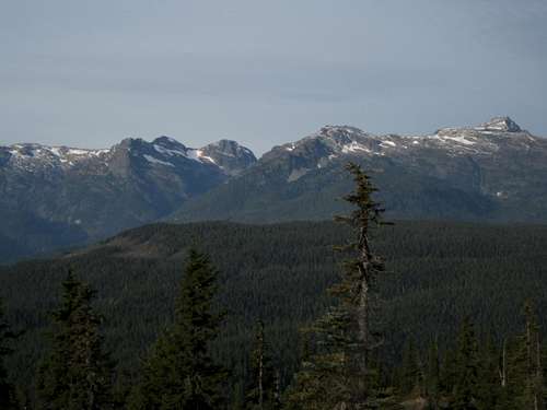 Summits to the west Summits to the west | 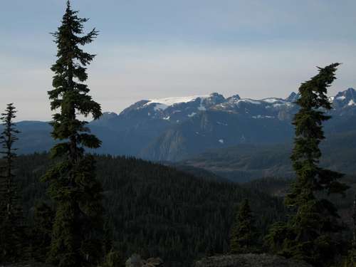 Comox Glacier Comox Glacier |
Camping
Camping right on the summit of Mt Drabble is one of the main reasons to visit the mountain. Unrestricted views, good water and lots of sheltered flat spots, make spending the night there an absolute must.If you do camp, there are no restrictions or fees. Just remember to practise your best no-trace methods, hang your food out ot the way of the local four-footed marauders, boil or otherwise treat your water and light no fires.
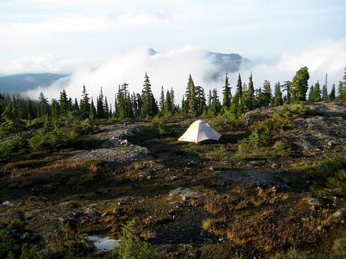
Mt Drabble summit camp
Red Tape and Safety Considerations.
There are no formalities to complete. You are not in any of the “core” areas of Strathcona where camping fees are due.There is line-of-sight from the summit of Mt Drabble to the nearby cellular repeater tower on the summit of Mt Washington and full service from there. I did not try to obtain a signal from any lower points on the mountain.
Useful Links
For more information refer to Island Alpine – A Guide to The Mountains of Strathcona Park and Vancouver Island, Philip Stone, Wild Isle Publications, 2003, ISBN 0-9680766-5-3For precise directions get hold of a copy of Backroad Mapbook. Volume III: Vancouver Island
If you are considering a winter trip, consult Vancouver Island Avalanche Conditions
Weather
Nearest point current conditions and forecast.OR
Check the weather at altitude right from Mt Washington’s webcam
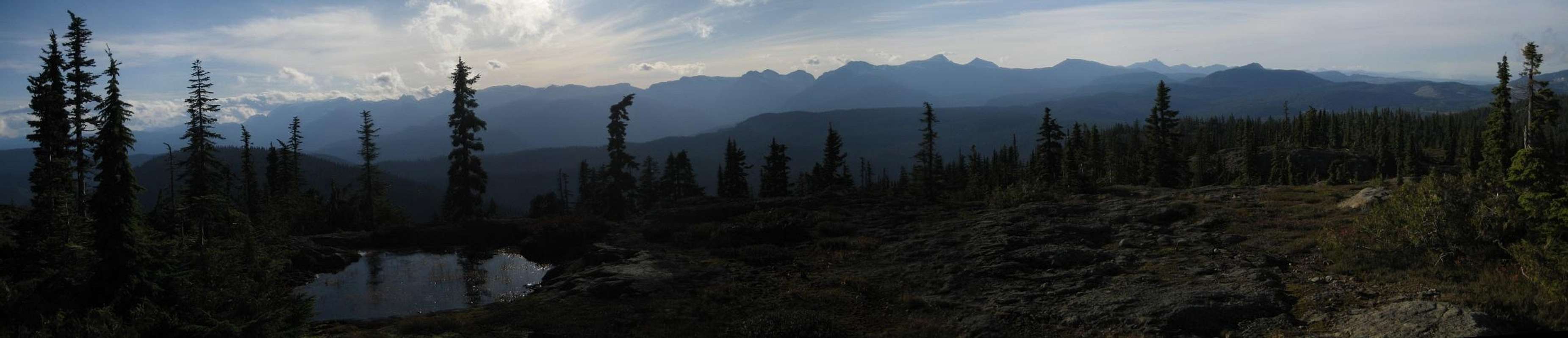
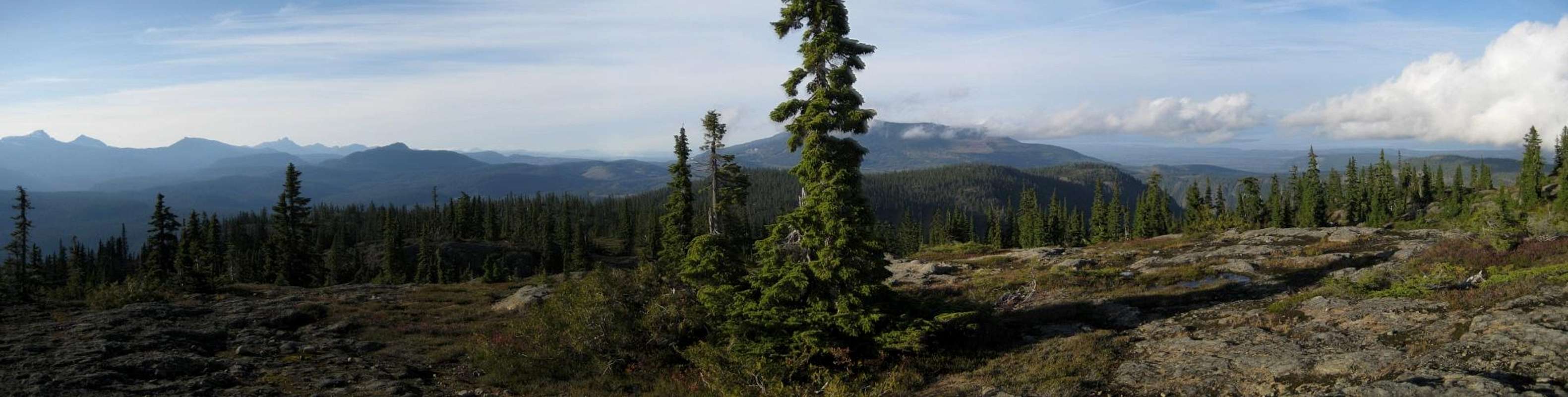
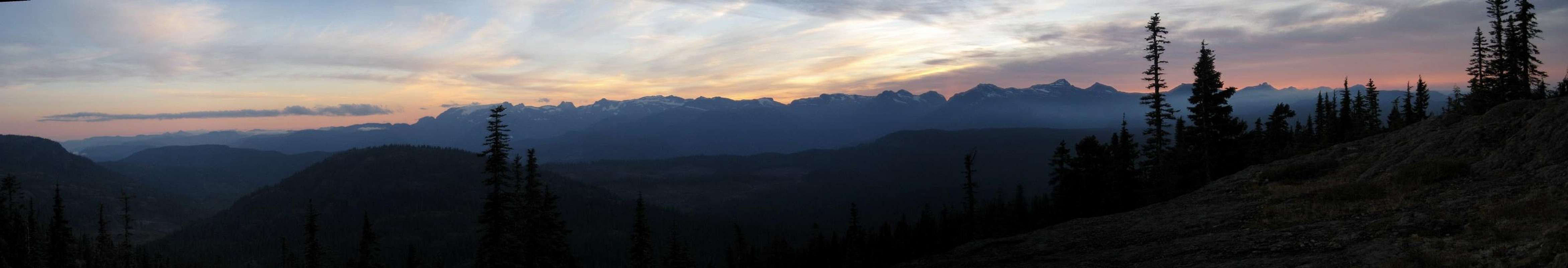
Summit Panoramas
A night spent on Drabble allows for photography of spectacular views in vastly different light conditions. Enjoy the following selection.  |
 |
 |
 |