|
|
Mountain/Rock |
|---|---|
|
|
40.54511°N / 111.70795°W |
|
|
Hiking |
|
|
Spring, Summer, Fall, Winter |
|
|
10516 ft / 3205 m |
|
|
Overview
The Obelisk is a smaller mountain, located north of the Pfeifferhorn, in the Central Wasatch Mountains. The environment surrounding the Obelisk is some of the most astounding and scenic terrain in the entire Wasatch Range.Looking south from the summit, you have an overwhelming view of the North Ridge of the Pfeifferhorn, the one of the more striking alpine routes in the Wasatch. Looking west, you can see the entire Hogum Fork with the Thunderbolt Ridge, Dresden Face, Snapdragon Couloir, Silver Couloir, and the Hypodermic Needle Couloir. Looking north, the entire Cottonwood Ridge is displayed before your eyes; and, looking east is the rugged outline of the Maybird Palisades and White Baldy.
The most common route to summit Obelisk is the Northeast Ridge. Obelisk is rarely climbed during the summer and provides ample solitude. During the winter, Obelisk is a more popular destination for backcountry skiing along the west and east faces.
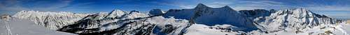
Summit Panorama
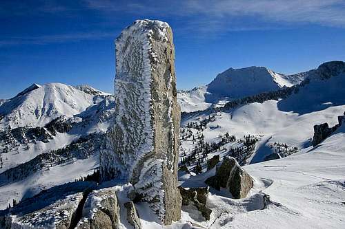
Looking east from the summit of Obelisk.
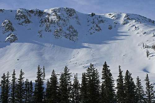
Ski lines on the east face of Obelisk.
Getting There
Take I-15 to 9000 South. Go east (toward the mountains) on 9000 South. The road will travel toward the mountains and merge with 9400 South. Continue east. The road will diminish to a two-lane street and travel through residential areas. You will arrive at the mouth of Little Cottonwood Canyon.You will know you're at Little Cottonwood Canyon when you reach the Y-junction. At this intersection, you'll see a large information board that flashes updates about canyon road conditions. From here, go up the canyon roughly 5.3 miles to the White Pine Trailhead Parking Lot. When you are close to the parking lot, the road will widen with an extra passing lane. On the right side of the road you'll see a brown sign that reads "White Pine Trailhead Parking Lot."
There are bathrooms and some information boards at the parking lot. Follow the trail that travels behind the bathrooms.
SabineInUtah - Jul 25, 2019 8:22 am - Hasn't voted
About a mile of boulder hoppingThe last mile or so is all on boulders/talus and requires some scrambling which means it is class 2+ or 3. Slow going if boulder hopping is not your thing. The approach is on easy trails. It's about 4 miles to reach the boulder field below the peak and about another mile to the summit for a 10 mile RT.