3D Raised-Relief Wall Maps
Product Description
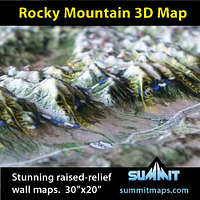
Summit Terragraphics has introduced a line of precision raised-relief wall maps specifically tailored to mountain sports enthusiasts. Some Summit maps use high-resolution satellite-images that are accurately molded into the shape of the terrain, providing an attractive and unique tool for understanding the topography and geographic features of mountain ranges. Other Summit maps use National Park Service visitor and trails maps, showing the various park features in their true 3D terrain shape.
Summit's maps cover the Colorado Rocky Mountains, Sierra Nevada Mountains, Southern California, and many national parks (Yosemite, Yellowstone, Grand Teton, Denali, Wrangell, and others). New maps are being introduced frequently.
Check out the entire 3D map collection at www.summitmaps.com.
Please send an email to Summit if you have an idea for a new location for a precision raised-relief map.
Features
3D molded shape clearly shows the terrain detail.High-resolution satellite images provide a true-earth reference tool.
Mountain peaks, trails, mountain ranges, roads and towns are marked/labeled.
Can be framed with black metal, black oak or natural oak finish moldings.
A unique and attractive display for the home or office wall of any mountain enthusiast.
Images
 |