
-
 1612 Hits
-
 74.92% Score
-
 5 Votes
|
|
Mountain/Rock |
|---|---|
|
|
38.78307°N / 21.94650°E |
|
|
Eyritania |
|
|
Hiking |
|
|
Spring, Summer, Fall |
|
|
6309 ft / 1923 m |
|
|
Overview
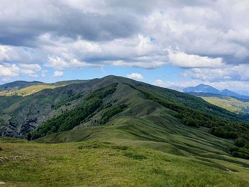
Mount Oxia (1,923m) [“Ορός Οξυά”] is one of Greece’s least popular and most remote mountain complexes, nestled on the border between Fthiotida and Evrytania in Central Greece, just north of Vardousia (2,495m). To its North is the river Sperchios (“Σπερχειός”), is fed through numerous gorges on its N slopes, while the mountain is separated from Oiti (2,152m) to the East through the “Gorge of Vistriza”. There are a few villages on the mountain with the ones with best access being Grammeni Oxia (“Γραμμένη Οξυά”), Gardiki (“Γαρδίκι”), and Domnitsa (“Δομντίτσα”). The mountain hosts some of the wildest and forested sections of land in Greece with plentiful wildlife including boars, wolves, and foxes, while its sub-alpine slopes are home to Europe’s Southernmost Beech Forest. Its highest summit is Sarantaina (1,923m) [“Σαρανταίνα”] and at the end of its ridge, to the East and at an elevation of 1,740m, lies the Refuge of the Hellenic Mountaineering Club of Lamia (EOS Lamias).
While the mountain is usually overshadowed by its neighbors Vardousia (2,495m), Tymfristos (2,315m), and Oiti (2,152m), Oxia, while having fewer imposing alpine sections, is steeped in nature and history, and also worth a visit. The mountain has little connection to the ancient world but has instead been a center-point for the Greek War of Independence (c. 1821) and its historic villages are today facing abandonment and disrepair.
History & Area Guide
|
|
|
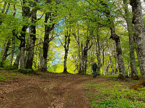
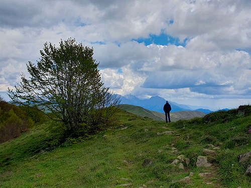
The mountain takes its name, “Oxia” (“Οξυά”), from the Beech trees covering, mainly, its Northern slopes around the summit ridge, at elevations up to 1,700m, this Beech Forest is the Southernmost in Europe and is a result of the dirt composition of the mountain, as opposed to the rocky nature of its neighbors. This has led to the growth of expansive Beech and Fir forests across the massif, which are further accommodated by the notably cold and snowy microclimate of the area. The lush vegetation, amble water, and unwelcoming winters have served to transform the mountain into a hub of wildlife activity from insects and reptiles to mammals and birds.
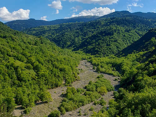
The Canyon of Kanalia, formed by an unnamed tributary of Sperchios and starting from the village of Pougkakia (“Πουγκάκια”) is an undisturbed wide canyon that is home to several monasteries as well as a plethora of wildlife. While there are no marked trails here, dirt roads originating from the surrounding villages as well as “goat trails” offer a level of access. This canyon is unique as it is gets incredibly wide for its elevation due to the soft composition of the mountain. On the more desolate West wall of the canyon, across from the village of Kanalia, is the Monastery of Madonna Roustiani (“Παναγιά η Ρουστιανή”). The road leading to both the monastery and the nearby abandoned village of Tserlakia is excavated through the dried riverbed every summer. It may be impossible to cross during early Spring at this location.
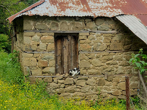
The villages at the slopes of Oxia present a curious time capsule at the heart of Roumeli (“Ρούμελη”) a historic center for Greek independence north of Athens. The villages are both small and traditional, with many having just one, or no businesses such as cafes, taverns, or shops. There are very few permanent residents (<50) at the majority of these villages, which do however get busier during national holidays – especially Orthodox Easter. The homes are traditional, utilizing local stone and wood while the infrastructure is generally poor. On the mountain an 1828 battle sealed control in the region for the Greeks and is today commemorated via a monument.
The mountain, as well as the Beech Forest are also called “Grammeni Oxia” (“Γραμμένη Οξυά”) meaning written Beech. This name originates from a local legend of the 16th century which says that when a local bandit chief and two of his comrades were caught in a tornado on the mountain, the chief was saved by grabbing onto a Beech tree, he would then write his name and the date of the incident on it. The name was officially given to the highest village on the mountain via a royal decree in 1927. The name of the summit, Sarantaina (1,923m) most likely refers to the death of a wedding party of 40 travelling through the mountain and caught by a snowstorm. The party probably travelled East to West as signaled by the names of certain villages on the Western slopes.
Getting There
The mountain is accessible from two villages those being "Grammeni Oxia" to the South and "Gardiki" to the North. The closest international airport is that of Athens. It is also possible, and easy, to reach these villages from the South via Patras if one is travelling by boat from Italy.
From Athens
From Patras
Route(s)
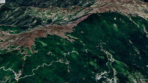
Refuge to Sarantaina – Main Ridge
Distance: 3.9km (one-way)
Duration: 1:30h (one-way)
Elevation Gain: 320m (one-way)
Difficulty: Easy
Water: Yes - Spring by Refuge
Overview
This route can also start at the monument of the “Battle of Grammeni Oxia” (c. 1828) at 1,680m if vehicle access to the refuge is limited. The route takes the ridge from above the refuge all the way to Sarantaina (1,923m) traversing 4km in 1:30h with the Beech Forest to the right for half the route. It offers amazing views of more than 6 mountains above 2,000m and opportunities to see wildlife.
Starting from the refuge at 1,740m begin by hiking West towards the ridge above the refuge, from here the trail is above the treeline. Continue W-SW up the slope until a dual summit is visible, this summit called Psilorachi (1,803m) can be skipped by traversing its North side but can also be ummited in an extra 5-10 minutes – up until here it is 30 minutes. From Psilorach continue W-NW with the ridge, which is now fully visible all the way to Sarantaina (1,923m). The ridge will descend all the way to 1,700m at the 45-minute mark, with the rest being the 223m ascent of the summit ridge. For most of this section the Beech Forest is to the right. It is recommended hikers follow the ridge and cairns, while there are “ghost” trails on the North aspect they will require a steeper hike to the summit. The summit is quite flat but not wind protected, there is a steep ravine to the South and good views in all directions. Follow the same trail to return to the refuge if you want to do so.
List of Highest Peaks
| Name | Elevation (m) | Elevation (ft) |
| Sarantaina | 1,923m | 6,309ft |
| Psilorachi | 1,803m | 5,915ft |
| Palaiolakka | 1,792m | 5,879ft |
| Alogovouni | 1,724m | 5,656ft |
| Kokkalia | 1,716m | 5,630ft |
| Karavi | 1,712m | 5,617ft |
When to Climb
In general this mountain is tough to access in the winter, as the roads are not regularly opened, especially the Grammeni Oxia pass. The best seasons to visit is late spring and early autumn, from after mid-April and then until early-November. Attempting in summer should also be easy depending on the weather and temperatures at the time, however, the mountain and surrounding area remain quite cold.
Huts & Camping
Oxia Refuge "Lambros Eytaxias"
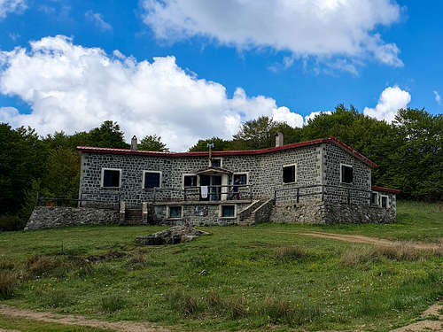
At 1,740m above the storied pass of Grammeni Oxia and at the end of the treeline, the "Lambros Eytaxias" mountain refuge operated by EOS Lamias is located. The refuge is on the main trail leading to the summit of Sarantaina (1,923m) and provides access to the trails leading to Vardousia to the south. The refuge can be opened upon request, it has a large mess, kitchen and living quarters as well as a bathroom, with showers but without hot water. It has sleeping capacity for up to 35 people, who must bring sleeping bags, although blankets can be provided. To get in touch with the refuge see the details on their Facebook Group.
External Links
Natura Graeca - Mt Oxia (Sarantaina), nature wiki [Greek]
Grammeni Oxia - village website [Greek]
Grammeni Oxia - Wikiloc
"The Forest of Grammeni Oxia", Western Greece through my Lens, Youtube
"How did Grammeni Oxia get its name?", Naupaktia News, 2021
"The Unknown Grammeni Oxia", Hiking Experience, 2011
EOS Lamias, Facebook
Oxia Refuge, Facebook