
|
|
Mountain/Rock |
|---|---|
|
|
48.79040°N / 116.6238°W |
|
|
Boundary |
|
|
Hiking |
|
|
Summer, Fall |
|
|
7265 ft / 2214 m |
|
|
Overview
 Unnamed Peak 7,265 rising above upper Ball Lake.
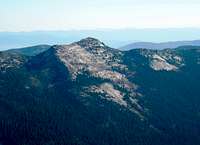 West Aspect
 Across Long Canyon
 The Summit Area
 Along the Ridge
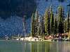
 Upper Ball Lake
 Summit Resident
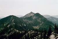 North side
 From the Northwest
The unnamed Peak 7,265 is the eighteenth highest point in the Selkirk Mountains south of the Canadian border, specifically the Priest Lake subgroup of that extensive range. It is sometimes referred to as Ball Peak due to its proximity to that high subalpine basin containing the two Ball Lakes. It has 525 feet of prominence and is the fifth highest point on the west side of remote Long Canyon, which is probably the remotest place in the northern Idaho Panhandle, though it is easily accessible itself. On the map this elongate ridge runs just under a half mile immediately to the west of the Upper and Lower Ball Lakes. The arête forms a divide between the deep glacial trough of Long Canyon and what appear to be small neve fields that hold the Ball Lakes and Pyramid Lake in the headwaters of Trout Creek and Spanish Creek, which is a tributary of Ball Creek. It is probable that the entire landscape in this area was covered by continental ice during the last major ice age, which along with later alpine glaciation leaves a dramatic landscape.
The summit area is fairly unremarkable being formed by steep straight slopes on the broad east and west faces and a smaller south face. The north end appears to have the steepest slopes with some cliffs before meeting with the generally level main ridge that runs north toward Pyramid Peak. The east side is quite accessible via the trail to Ball Lakes followed by a steep, but not very difficult scramble up the east side. This wall rises approximately 600 feet above the Ball Lakes and 1,800 feet above the trailhead in the bottom of upper Trout Creek. The mountain rises approximately 2,500 feet above Long Canyon to the west.
The hike up this mountain is relatively short and easy, but it offers spectacular views of the Selkirk Crest through high subalpine forests and alongside three beautiful cirque lakes. The hike up trail cut in the headwall above Pyramid Lake is especially scenic. The summit views of this centrally located Selkirk summit ties in the rugged southern crest with the less dramatic, but higher peaks of the north.
Getting There
 The upper east slope of unnamed Peak 7,265 rising above upper Ball Lake.
 Trail near Pyramid Lake
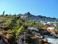 Going up
 Trail above Pyramid Lake
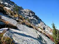 On the east side
 At Ball Lakes
 Summit
The easiest route is via Pyramid Lake from the east. From Bonners Ferry, exit Highway 95 into downtown and get on the road heading west from town on the south side of the Kootenai River. To find this road just head north a couple downtown blocks and you’ll be there or exit immediately before crossing the bridge over the Kootenai River. Continue on this road for about four miles to the Kootenai National Wildlife Refuge. Take a right towards the refuge headquarters on the West Side Road (road 18). The road turns to gravel and continues north along the east foot of the mountains. The wetlands to the east are a good place to spot moose, especially in the mornings. Continue north on the West Side Road for approximately 11 miles to the Trout Creek road. Turn left and head up the narrow road 10 miles to the trailhead.
Follow Trail 13 for half mile to the Pyramid Lake turnoff (Trail 43). Make the left turn and continue about a half mile to Pyramid Lake. This high lake is very picturesque with two lobes below spectacular cliffs; however, it can be heavily used due to the easy access. At the lake follow the trail to the left away from the lake. It will swing onto the slope south of the lake and then cut back to the cirque wall above the lake before ascending the steep slope and cliffs to the Ball Lakes basin above. The trail continues to upper Ball Lake where one can hike around the lake to either the north or south before a steep, but straightforward scramble up the granite to the summit ridge. There are multiple potential lines up the slope with only a few real obstacles to avoid. Once on the ridge, it’s an easy walk to the high point. The net climb from the trailhead is a little over 1,800 feet.
Red Tape
None.You may have trouble parking at the trailhead on weekends. The fact that there is not physically space to park in the few designated spots may not be considered when it comes time to write citations. Either risk a ticket or find a wide spot a mile or two down the road and extend your hike.
Camping
 Upper Ball Lake from the main camping area on the east shore.
There is easily accessible camping at Pyramid Lake or either of the Ball Lakes at the east foot of the summit. The upper Ball Lake is an especially nice setting. All of these areas are close to one of the busiest trailheads in the mountains so don’t expect privacy, especially on the weekend. The way the trail passes through the upper Ball Lake area there is a high potential for people walking through or very near any camp. The best solitude may be at the lower Ball Lake, which is a little further and due to the brush and rocks may not have as many nice camping sites.
 Upper Ball Lake from its outlet. The mountain is to the left.
 Above Pyramid
 Upper Ball Lake
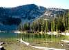

When To Climb
In the high Selkirk Mountains some snow patches hang on well into July and even August in cooler summers. Hiking over these is generally no problem, but the trailheads and trails may be buried in deep snow from late October through most of June. The lower elevations of Trout Creek will be accessible in April and May, but climbing getting very high to the west will not be possible.Mountain Conditions and Information
 Peak 7,265 from Pyramid Peak on a smokey day.
Forest Supervisors Office
3815 Schreiber Way
Coeur d'Alene, ID 83815-8363
(208) 765-7223
Bonners Ferry Ranger District
6286 Main Street
Bonners Ferry, ID 83805-9764
(208) 267-5561
Current conditions for a variety of features such as snow, roads, weather, etc. can be found on the Idaho Panhandle National Forest web page.
NOAA Forecast for the central Selkirk Crest.
 Upper Ball Lake and the Selkirk Crest.