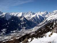
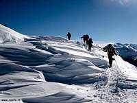
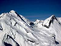
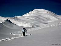
The Punta Fetita, also called Felita or Falita, offers a wonderful panorama on the main tops of Aosta Valley. In summer the ascent is a simple trekking but it’s in winter and spring that this mountain shows the best because absolutely free of avalanche dangers also after a big snowfall. The mountain is frequently climbed all the year long because easy and included in a high attending touristic area. This applies to the paths on the ridge, as regard the Ski-Mountaineering on its Western Slope occurred in recent years various misfortunes mortals, due to great avalanche. To avoid in any case and especially with high snow and not well transformed.
WGS84 UTM Zone 32T
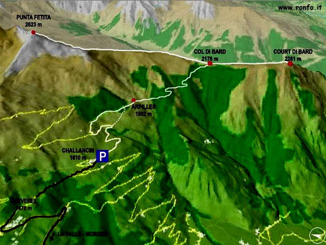
Challancin (starting point)
351375 E
5069090 N
Arpilles
352274 E
5069174 N
Col de Bard
353293 E
5068245 N
Court de Bard
353265 E
5066839 N
Punta Fetita
352817 E
5070891 N
La Punta Fetita, chiamata anche Felita o Falita, offre un meraviglioso panorama sulle principali cime della Valle d'Aosta. In estate la salita è una semplice escursione, ma è in inverno e primavera che questa montagna mostra il miglior aspetto perché assolutamente priva di pericoli di valanghe anche dopo una grande nevicata. Risulta spesso salita tutto l'anno, perché facile e facente parte di un turismo con alta partecipazione in tutta questa area area. Questo vale per i percorsi in cresta, poiché per quanto concerne lo Sci-Alpinismo sul suo Versante Occidentale si sono verificate negli ultimi anni diverse disgrazie mortali, a causa di valanghe. Da evitarsi in ogni caso e soprattutto con neve alta e non ben trasformata.
Getting There
The mountain village of Challancin is the nearest base to climb the Punta Fetita but considering that the trekking takes only 6 hours to go up and back, also the small towns of La Salle or Morgex are appropriate. To arrive to the village of Challancin: start from the town of Aosta (580m) in the direction of Courmayeur Mont Blanc. After 20 Km, keep the right in La Salle, following the direction Planaval-Cheverel-Morge (not Morgex) and, when in Cheverel, keep on the right for Challancin (1.610m).
Route Description
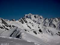
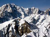
From La Salle come up with the paved road to the overlying Fractions of Croix des Prés, Cheverel (1.470m) and Challancin (1.610m; small parking lot) from this village up towards the Northeast through the path n° 2 coming to Les Ponteilles Pastures (1.731m). Abandoning the left (North) trail that climbs n° 2A to Les Ors Alpages, mostly in Southeast instead continue reaching Arpilles Pasture (1.862m; beautiful fountain), take an immediate right into the path that goes into the woods and climb with short diagonal alternating hairpin bends that back with beautiful views of the iced North Face of Mont Paramont which stands directly opposite. Crossed the two small Torrents of Arpilles and Charvaz with a diagonal more "quiet" to the right to reach the Bard Pass (2.176m). Continue on the ridge dividing the North and go to the next Borromein Hill (2.319m), and always with the same kind of path, after a round antesummit 2.442 meters, the two Tops Fetita or Felita and even Falita (2.623m; 1h'30 from the Col de Bard).
Da La Salle salire con la strada carrozzabile verso le soprastanti Frazioni di Croix de Prés, Cheverel (1.470 m) e Challancin (1.610 m; piccolo parcheggio); da questo villaggio salire verso Nordest tramite il sentiero n° 2 arrivando all'Alpeggio Les Ponteilles (1.731 m). Abbandonando a sinistra (Nord) il sentiero n° 2A che sale a Les Ors, continuare invece maggiormente a Sudest raggiungendo quello di Arpilles (1.862 m; bella fontana); prendere subito a destra il sentiero che si addentra nel bosco e risalire con brevi diagonali alternati a stretti tornanti che lo risalgono con bella vista sulla ghiacciata Parete Nord del Mont Paramont stagliantesi di fronte. Attraversati i due piccoli Torrents de Arpille e Charvaz con un diagonale più "tranquillo" verso destra si raggiunge il Col de Bard (2.176 m). Si continua sulla cresta divisoria con direzione Nord raggiungendo il successivo Col Borromein (2.319 m) e, sempre con lo stesso tipo di percorso, dopo una arrotondata antecima 2.442 metri, le due Punte Fetita o Felita (2.623 m; 1h'30 dal Col de Bard).
Red Tape
No permits, fee or seasonnal closures or parking pass except the prohibition to camp out of the authorized campings. Out of the authorized campings it is possible to set a tent only from 19 pm to 7 am over the 2.500m.
When To Climb
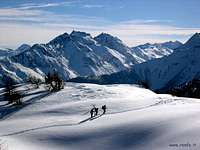
The Punta Fetita can be climbed all the year long but the best periods are the winter, from Christmas to end of march with ski and snow rackets, and the spring.
La Punta Fetita può essere salita lungo tutto l'anno, ma i periodi migliori sono l'inverno, da Natale a fine marzo con le racchette da neve o tramite gli sci, e la primavera.
Camping
In Challancin there is no possibility to camp but in the near La Salle and Morgex several campings are open all the year long:Camping du Parc 0165-809260 du.parc@libero.it (Morgex) Green Park 0165-861300 (La Salle) International Mont Blanc 0165-861183 (La Salle) Close to Challancin there are only little hotels: Challancin: "Hotel Col du Bard" tel. and fax 0165-861295 Cheverel: "Hotel Cheverel" tel. and fax 0165-861293 www.valdigne.com and "Les Combe" 0165-863982 www.lescombes.it. Planaval: "La Jolie Bergère" open from april to october tel. 0165-861292.
Mountain Conditions
Meteo: you can find all the needed informations at the official site of the Valle d'Aosta Region:
"Guida dei Monti d'Italia-Alpi Pennine" (Vol. I°) di Gino Buscaini-Club Alpino Italiano/Turing Club Italiano, Luglio 1971 (in Italian).
"80 itinerari di Escursionismo Alpinismo e Sci Alpinismo in Valle d'Aosta", di Osvaldo Cardellina, Ed. Musumeci, Giugno 1977 (in Italian); seconda Ed. Luglio 1981; terza Ed. Luglio 1984; (in French), prima Ed. Febbraio 1978; seconda Ed. Marzo 1980.
MAPS
Kompass "Monte Bianco Valle d'Aosta Sentieri e Rifugi" Carta turistica 1:50.000.
I.G.C. Istituto Geografico Centrale "Carta dei sentieri e dei rifugi" 1:25.000.
I.G.M. Istituto Geografico Militare 1:25.000.
Important Information
Protezione Civile Valdostana località Aeroporto n° 7/A Saint Christophe (Ao) Tel. 0165-238222.
Children refers to the set of objects that logically fall under a given object. For example, the
Aconcagua mountain page is a child of the 'Aconcagua Group' and the 'Seven Summits.' The
Aconcagua mountain itself has many routes, photos, and trip reports as children.
Parents refers to a larger category under which an object falls. For example, theAconcagua mountain page has the 'Aconcagua Group' and the 'Seven Summits' asparents and is a parent itself to many routes, photos, and Trip Reports.

 7933 Hits
 90.13% Score
 31 Votes