Overview
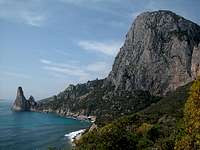
![Punta Griadili]() Punta Giradili seen from Padra Longa on the east coast of Sardinia
Punta Giradili seen from Padra Longa on the east coast of Sardinia
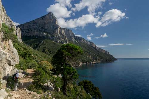
Punta Giradili is one of the most beautiful cliffs on Sardinia's east coast - which is the reason why its picture shows up on quite many trip reports of the island. The guidebook I used for hiking on Sardinia shows Punta Giradili on its cover (see below and to the left). The mountain towers 730 vertical meters above the sea and is one of the most attractive climbing locations of the island. Even the normal ascent along the southwestern ridge is quite difficult due to its exposure above the 250 - 400m vertical drops.
Part of the attraction of the mountain is the sea below. Coloured in all shades of turquoise - bright over the white beaches - deep blue over the rocks farther out - sea and mountain seem to form a perfect synthesis between rock and water. Fill in some clouds - they rather often hover around the summit - and you'll get an image you'll probably never forget.
There are two hiking and four climbing routes onto Punta Giradili. The climbing routes are rated 6a through 7b+. The surrounding cliffs - Punta Argennas (710m), Cuccuru Maore (696m) to the south and Monte Ginnirco (811m) - also show impressive vertical though only for the latter climbing routes are known.
Climbing Punta Giradili

There are four routes:
- Mediterraneo - 7a+ / 350m / 8 pitches
- L'intelligenza emotiva - 8a / 350m / 9 pitches
- Piola / Motto - 7a / 220m / 6 pitches
- Wolfgang Güllich 7a / 400m / 12 pitches
Since I didn't climb any of the routes - never done anything like it - I prefer to direct you to a couple of web pages with much better information than I could provide. The topo is linked from
www.planetmountain.com.
![Climbers on the Punta Giradili south face]() Climbers beneath the summit Climbers beneath the summit |
Pietra Longa
![Arbatax peninsula and Pietra Longa]() Arbatax peninsula and Pietra Longa, the trailhead for Punta Giradili
Arbatax peninsula and Pietra Longa, the trailhead for Punta Giradili
The more popular of the two trailheads is at Pietra Longa on the east coast a little southeast of Punta Giradili. Pietra Longa is a tower - quite typical for the bays on the east coast that rises vertically out of the sea. Unfortunately the rock is rather fragile so that climbing won't be much fun. Nevertheless it's one of Sardinia's best known landmarks.
The Trecking Trail "Sentiero Selvaggio Blu"
There is a multiday trecking trail along the eastern coast of Sardinia -
Sentiero Selvaggio Blu. It is - as trecking trails go - an extreme trail, since it contains passages of grade IV as well as some rappeling. The trail starts at Pietra Longa and runs through all the climbing areas of the east coast - Punta Giradili, Cala Goloritzé, Cala Luna - before it finally ends at Cala Gonone. The average trecking time for the whole trail is eight days. The trail is marked (by blue arrows) but much of it is overgrown so you need a quite good sense (and equipment) for orientation.
The ascent to Punta Giradili from Pietra Longa in its first part runs along Sentiero Selvaggio Blu before it turns up towards the mountain. Having skipped the intersection we spent the whole day on the sentiero taking pictures of Punta Giradili's surroundings.
Getting There
Sardinia can be reached either by plane or by ferry. The main ports are Porto Torres and Olbia in the north and Arbatax and Cagliari in the south. Airports are at Alghero and Olbia in the north as well as (again) Arbatax and Cagliari in the south. For exploring the northeastern part of the island where most of the mountains are the best entry point is Olbia, which is where most flights go anyway.
There are two trailheads for the mountain, one in the town of Baunei the other directly on the coast at Pietra Longa, a limestone spire which rises out of the sea.
Approaching the mountain from Olbia airport
Get on motorway SS 131 south in the direction of Siniscola / Nuoro. At the exit Lula / Dorgali get off and turn onto SP38 south (again direction Dorgali). Shortly before you reach Dorgali, SP38 ends and you switch to SS125 direction Dorgali.
Get through the town (signs Cala Gonone, Baunei) and soon you'll drive along one of the most beautiful roads of the island above the Flumineddu valley. SS125 takes you to the mountain town of
Baunei. Go through the town and at km153 a side road turns off to the left. It leads to
Pietra Longa (see below), where you can find several parking lots.
Approaching the mountain from Arbatax airport
From the airport take SS125d towards Tortoli, where you switch to SS125 north, direction Baunei. At km 153 turn right onto the side road towards
Pietra Longa or drive on a few km until you reach
Baunei.
![]()

 23421 Hits
 86.85% Score
 23 Votes
 Punta Giradili seen from Padra Longa on the east coast of Sardinia


 Climbers beneath the summit
 Arbatax peninsula and Pietra Longa, the trailhead for Punta Giradili