
-
 28757 Hits
-
 93.52% Score
-
 43 Votes
|
|
Mountain/Rock |
|---|---|
|
|
40.10716°N / 9.69008°E |
|
|
Sardegna |
|
|
Trad Climbing, Sport Climbing |
|
|
Spring, Summer, Fall, Winter |
|
|
469 ft / 143 m |
|
|
Overview
Geographical classification: Sardegna - Sardinia > Supramonte > Aguglia di Goloritzé
Aguglia di Goloritzé 143 m
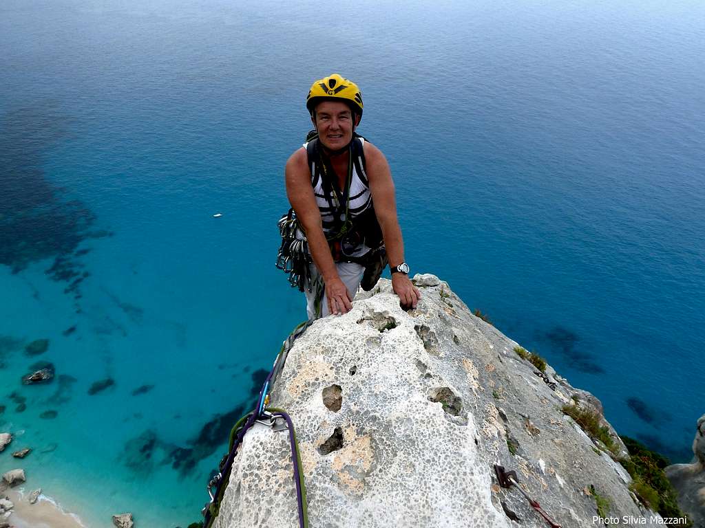
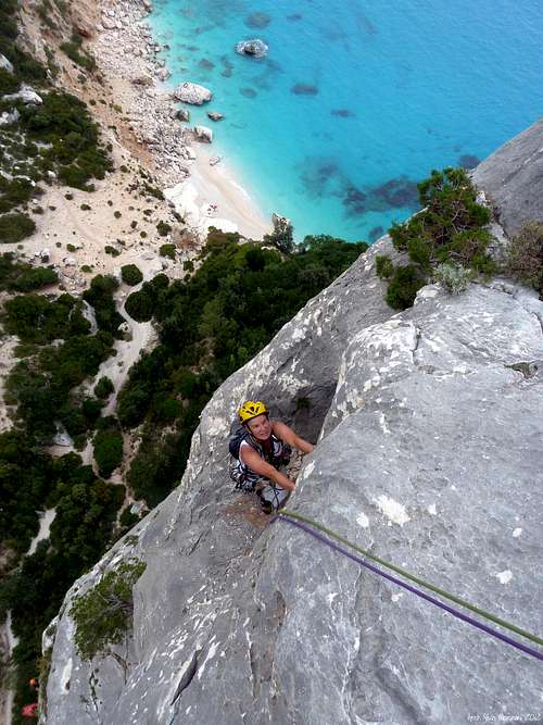
Only 143 meters high? It doesn’t mean! Aguglia di Goloritzè is without any doubt one of the finest rocky structures in Italy: a superb shape, an outstanding exposure over the turquoise sea, a high-quality limestone and a wild environment. This incredible obelisk lies inside the Supramonte di Baunei and overlooks with its grey slender shape the white beach of Cala Goloritzè, one of the most suggestive bay of Sardinia and maybe of the whole Mediterranean Sea. It can only be reached by sea or via a path starting from the Altopiano del Golgo (Golgo plateau).
The Aguglia is a dream, so each year several parties are coming here from all Europe to compare themselves to the incredible needle, due to the outstanding quality of the limestone, sculpted by billions of “water drops”, the charming of its climbing routes, numberless at present, and the superb views appearing from the tiny summit, on which one can hardly straighten up. A wild marine “milieu”, the secluded situation, the remoteness from the civilization adds to the experience a surplus of charm.
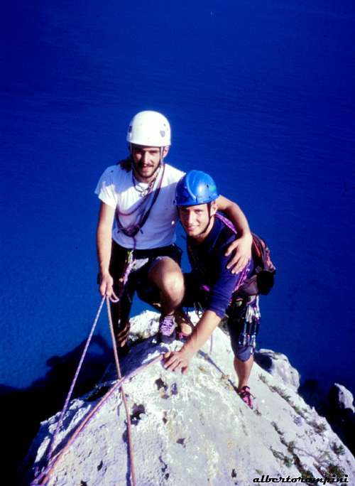
Notwithstanding its beauty and the quality of the rock, as well as the wonderful landscape, the Aguglia was climbed for the first time only in the Eighties, because of the appearance of its walls, impressive and overhanging all around. Its reputation for inaccessibility was broken in the winter of 1981, when Maurizio Zanolla “Manolo” and Alessandro Gogna reached the tiny summit of the Aguglia during a violent wind-storm. The reason why they gave to the route the suggestive name of “Sinfonia dei Mulini a Vento” (“Symphony of Windmills”). Later other routes were added and currently we find more than 10 multipitch routes with difficulty from 5c up to 7b+. On the most climbed routes the limestone, although of excellent quality, is rather smoothed by the high attendance. In addition to "Sinfonia", the most attended routes are Easy Gimnopedie, the easiest one, the famous Sole Incantatore (6c max), Dolce stil novo (6c max) and the difficult Itu Damagoni (7a+).
Getting There
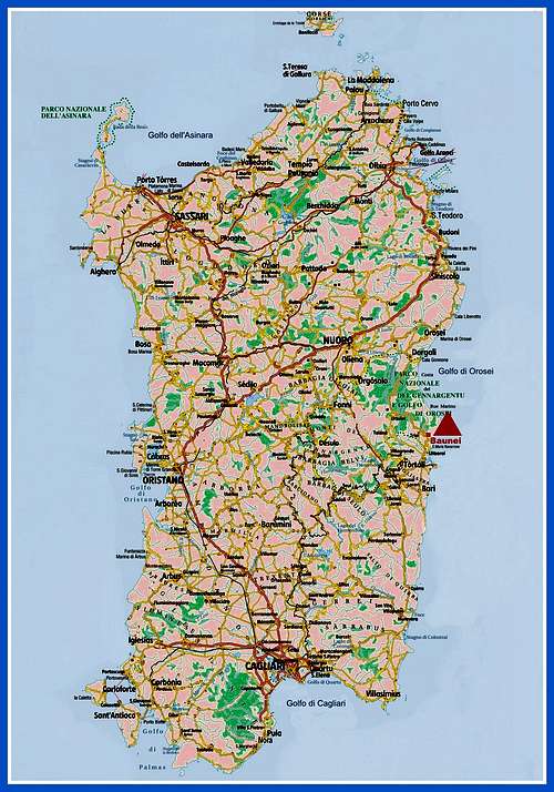
Access to the island of Sardinia
Sardinia, the Westernmost region of Italy, can be reached by plane or by ferry-boat from Livorno, Civitavecchia and Genova harbors. The most convenient destination in Sardinia to visit the Supramonte di Baunei, one of the wildest region of the island, is the airport of Olbia if you’re getting there by plane; the same Olbia or the near Golfo Aranci harbors if you’re getting there by ferry-boat.
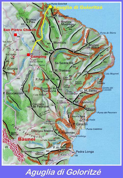
The starting point to approach Aguglia di Goloritzè is the village of Baunei.
Road approach
From Olbia or Golfo Aranci, situated just a few kilometers North to Olbia, follow the quick Motorway SS131 towards Nuoro and Siniscola, exit Lula. From here head towards Dorgali on the road SP 38, cross the town and continue, running on the superb and panoramic road SS125, named ”Orientale Sarda”, leading to the village of Baunei. From Baunei, just before entering the village, turn to the left following the road to the picturesque Church of San Pietro in Golgo (signpost Ristorante del Golgo). After a steep section with hairpins the road reaches the plateau. Follow the paved road for some kilometers and some hundred meters before getting to the church turn to right, entering a gravel road (signpost Goloritzé) which passes the Abisso del Golgo (Su Sterru, 270 meters deep) and ends nearby an equipped camping (“Su Porteddu”). Paying parking inside the camping area.


Walking approach
- From the camping follow a good path briefly rising on the tableland, then entering into a narrow valley - named Bacu Goloritzé - amongst a few typical shepherd’s ancient caves. The path continues downhill and reaches to Cala Goloritzè. Some minutes before getting to the beach the path is skirting the North-East face of the obelisk (1 hour from the parking downhill, 1,20 uphill).
Aguglia di Goloritzè main routes (French Scale)


North wall
The North wall, the first one you find when coming from the access path, is the one with the least difficult routes and is therefore much more frequented. From left to right we find:
- Sinfonia dei Mulini a Vento – North face 6b+ max, 5c obbl., 165 m. - Maurizio Zanolla, Alessandro Gogna 22-01-1981 - Equipped belays, some friends are needed to integrate the pegs along the pitches
- Sole incantatore - North face 6c max, 6a+ obbl., 140 m. - Maurizio Oviglia 1995 - Fully equipped (bolts)
- Easy Gymnopedie - North-West face 6b max, 5c obbl., 140 m. - L. Nadali, M. Amadori 1988 - Re-equipped by E. Lecis - Fully equipped (bolts)
Sinfonia dei Mulini a Vento (“Symphony of Windmills”) report

Sinfonia dei Mulini a Vento (“Symphony of Windmills”) report - French Scale
Summit altitude: m. 143
Difficulty: 6b+ max., 5c obbl
Climbing length: 165 m.
Exposure: NE
Equipment: few equipped, necessary some friends and nuts
First ascent: Maurizio Zanolla “Manolo” and Alessandro Gogna 21-4-1981
A spectacular route on excellent limestone, considered the Normal route and the first one to be climbed on Aguglia di Goloritzè. It can’t be missed! Here the climber can find all the climbing ways, from the technical slabs, to the cracks, corners and chimneys. It’s the easiest route to gain the summit, but it’s also the less equipped. The starting point is in the middle of the North-East wall, near the lowest point of the face.
L1 – Climb a system of thin slanting cracks to a tree, then up some easier rocks heading to the left and leave on the right the belay of the route “Sole Incantatore”. Climb a white slab to a shallow corner, leading on the right to the first belay. 5c, 6a, 45 m.
L2 – Up to the bottom of an obvious chimney, between the main wall and a detached pillar on the left. 4b, 10 m.
L3 – Up the fine smooth chimney, keeping the left wall and then use the chimney technique to reach the first distant peg. Continue with the same technique and exit to the shoulder of the detached pillar, 6a, 15 m.
L4 – Climb a beautiful thin crack, becoming a shallow and difficult corner, leading to the ridge. Belay on the ridge. 6a, then 6b+, 20 m.
L5 – Don’t follow the bolts of the route Spigolo Turchese on the ridge, but traverse easily towards right reaching a good ledge. 3c, 10 m.
L6 – Climb the Y shaped crack cutting the slab and at the fork follow the right branch, belaying on a small terrace on the right along the N ridge. Superb pitch. 6a+, 35 m.
L7 – Return left to climb a small corner, then a sloping slab. Up the last small wall to the airy and tiny summit. 4c, 30 m.
Descent - Rapping along the route “Sole Incantatore” (on the left of “Sinfonia”, facing out). At first a 10 meters abseil leads to the fifth belay of “Sole Incantatore”. From here with other 4 or 5 abseils – depending by the length of the ropes – to the bottom of the obelisk.
"Sole Incantatore" report
"Sole Incantatore" report - French Scale
Summit altitude: m. 143
Difficulty: 6c max., 6b obbl
Climbing length: 135 m.
Exposure: NE
Equipment: equipped with bolts, quickdraws and 2 × 50 m or single rope 70 m, friends and nuts are not necessary
First ascent: Maurizio Oviglia, from above, 8 April 1995.
"Sole Incantatore", meaning "Charmer Sun", is a very brilliant route to the summit. The climb is sustained, although the hardest moves can be aided. The starting point is in the middle of the North-East face, nearby the lowest point of the face, and follows for a while the first pitch of "Sinfonia dei Mulini a Vento".
L1- In common with Sinfonia, normal pegs up a dihedral-crack, then head to right to reach the first belay of "Sole Incantatore", while "Sinfonia" heads to left, 5b
L2 - Climb the compact slab up to the base of an overhang. Overcome it and continue along easier rocks up to the base of a vertical slab, where it's situated the belay. This pitch can be combined with the previous one, 6b
L3 - Directly above the belay climb a strenuous vertical wall, which is followed by an easier section and then by a new vertical wall. Belay on a vegetated ledge, 6b+
L4 - Three lines of bolts are present here, "Sole" follows the middle one, that directly overcomes the smooth wall. Climb the wall leftwards to find the best holds. A tricky pitch. Exit to the left on an uncomfortable belay, 6b+.
L5 - Overcome with difficult moves the bulge above. Continue up the smooth and still-difficult rib. Belay at the base of summit needle, 6c (6b obbl)
L6 - Easy climb to the summit, this pitch can be combined with the previous one.
Descent: rapping along the same route

|

|
Easy Gymnopedie report
Route report - French Scale
Summit altitude: m. 143
Difficulty: 6b max., 5c obbl
Climbing length: 140 m.
Exposure: NW
Equipment: equipped with bolts, quickdraws and 2 × 50 m or single rope 70 m, friends and nuts are not necessary
First ascent: L. Nadali, M. Amadori 1988 - Re-equipped by E. Lecis
Pleasant climb on excellent limestone, the easiest to summit the Aguglia.
L1 - After a slightly smooth crack with a challenging step, go up obliquely to the right, 6a
L2 - Overcome a small overhang (crux move of the route), then on easier steps, 6b (A0)
L3 - Slab with a crack, terrace on the right and finally overhang with good holds, 6a
L4 - Difficult start above the belay, then easier ground and fine slab well worked, 6a+
L5 - Directly on the edge of the spur, then a right traverse to reach the beautiful final slab. A final wall to the top, 5c
Descent: rapping along "Sole Incantatore"
Other routes on East and West walls

East wall
- Itu Damagoni (Il mio Veleno) 7a max, 6c obbl., 140 m. - M. Zanichelli, L. Nadali 1986 - Fully equipped (bolts)
- Dolce Stil Novo 6c max, 6a obbl., 120 m. - Fully equipped (bolts)
- Spigolo Turchese 6c max, 6b obbl., 100 m.
West wall
- Il soffio del baco 6c+, 6a+ obbl., 135 - P. Ravasio, S. Zizioli 1995 - Fully equipped
- Buon anno simpatia 6c, 6b obbl., 165 m. - L. Nadali, Giuliana Scaglioni 1986 - Few equipped, a complet set of friends and nuts is essential
- L’Orsetto lavatore e il suo compare 7b+/A0, 6c+ obbl.,115 m. - F. Dessi, G.L. Piras 1995 - Fully equipped (bolts)
Climate
The climate is typically Mediterranean; plenty of sunshine, mild temperatures, poor rainfalls and windy weather. Some rainfalls usually occur from October to March and sometimes they may be violent, but generally brief. The mild climate of the island allows the climb all around the year, though South faces are always too hot in summer. Sometimes the NW wind (maestrale) may be a problem, when it’s very strong.
Red Tape

The Baunei area is lying inside Parco Nazionale del Gennargentu e del Golfo di Orosei. The wild territory of the park belongs to the Nuoro, Ogliastra and Cagliari provinces and had been established in 1998. Its 73.935 hectares' extension includes 18 communes: Aritzo (NU), Arzana (OG), Baunei (OG), Belvi (NU), Desulo (NU), Dorgali (NU), Fonni (NU), Gadoni (NU), Gairo (OG), Oliena (NU), Orgosolo (NU), Seui (OG), Seulo (CA), Talana (OG), Tonara (NU), Urzulei (OG), Ussassai (OG), Villagrande Strisaili (OG).
No particular restrictions in hiking and climbing inside this area; from August 2016 a fee has been imposed to walk on the path to Cala Goloritzè (6 euros). Cars must be parked with care, only in the camping area and in any case without encumbering the existing shepherds' roads. Fires are strictly forbidden and the whole fauna and flora is protected. Don’t disturb fauna and other mountaineering and hikers’ peacefulness with every kind of noise.

When to climb
It’s possible to climb all round year, finding good conditions in every season; yet in winter the winds may sometimes be strong and cold and in summer the sun may be as much strong.
Where to stay

- B&B, apartments and hotels in Baunei, S. Maria Navarrese, Cala Gonone and Dorgali
- Camping in Cala Gonone
Meteo
Meteoblue Sardinia
Meteo ARPA Sardegna
Maps
|
|
Guidebooks


- Pietra di Luna - Trad & Multipitches Maurizio Oviglia Trad and sport multipitch guidebook - V updated edition Fabula 2015
- Sardegna Maurizio Oviglia Guida dei Monti d'Italia Club Alpino Italiano - Touring Club Italiano 1997