Overview
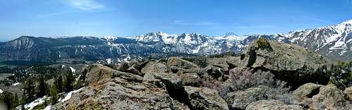
South panorama from Reversed PeakThe June Lakes Loop is a 16 mile drive on Hwy 158 that passes around a favorite resort and recreational area open all year and includes skiing on June Mtn. as well as
San Joaquin Mountain and
Mt. Wood for the advanced. It is tucked into a northeast facing cirque below the peaks of the Eastern Sierra with 4 lakes around its base and creeks connecting them. The water flows clockwise from June Lake all the way around to Grant Lake at the northwest end of the cirque. Reversed Creek goes back toward the range and connects with Rush Creek as it flows northeast through Silver Lake, Grant Lake and on to Mono Lake. Reversed Peak tops a massif that dictates this drainage from the northwest part of the cirque. It has sweeping views of the peaks surrounding the area, Mono Lake and east to the
White Mountains.
Getting There
Reversed Peak west side from the June Lakes LoopFrom the junction with Hwy 120 and Hwy. 395 go south 21 miles to the June Lakes junction. From Mammoth Lakes, 15 miles north to the junction. Go 1 mile west and turn right on the paved road before June Lake to the end as it curves northwest 1 mile on the north side of the campground. Hike west up a sandy moraine to a hanging valley below the east slope of Reversed Peak. Straight up the east slope is full of chaparral if you're a glutton for punishment, an unwanted class 2 shred and scuffle! Better to go about a mile southwest and take the walk-up southeast slope to an easy class 3 summit. The west slope is very steep and looks to offer some class 3-4 routes from the June Lake loop south of Grant Lake.
Red Tape
San Joaquin Mtn. and Carson Peak from the north No permits required. Check
June Lakes Loop in external links for current weather conditions. This is an easy half day hike where you can take advantage of the resort area before or after the hike for a good meal.
Camping
White Mtns. from Reversed PeakThere are National Forest campgrounds at the north and south end of June Lake one at Gull Lake and one at Silver Lake. No restrictions for overnight in this Inyo National Forest area.
Etymology
"Reversed Creek, Peak": "The ancient drainage has been reversed by the deposition of morainal debris; we have therefore called the stream draining June and Gull Lakes, Reversed Creek. The drainage before the site of June Lake was occupied by a glacier must have been northward" (Russell Quantenary, 343.) The Peak was named for the creek by USGS surveyors: both names are on the Mt. Lyell 30' map,1901. (INF) "Place Names of the Sierra Nevada", Peter Browning
External Links
Eastern Mojave Vegetation
June Lake Loop
Donno - Sep 16, 2019 7:22 am - Hasn't voted
Getting ThereThe photo in the Getting There section is a sub-peak of Reversed Peak. There is a trail to the summit on the south side of the mountain.