
-
 5733 Hits
-
 83.1% Score
-
 16 Votes
|
|
Mountain/Rock |
|---|---|
|
|
47.07912°N / 9.76873°E |
|
|
Hiking, Scrambling, Via Ferrata |
|
|
Summer, Fall |
|
|
8258 ft / 2517 m |
|
|
Overview
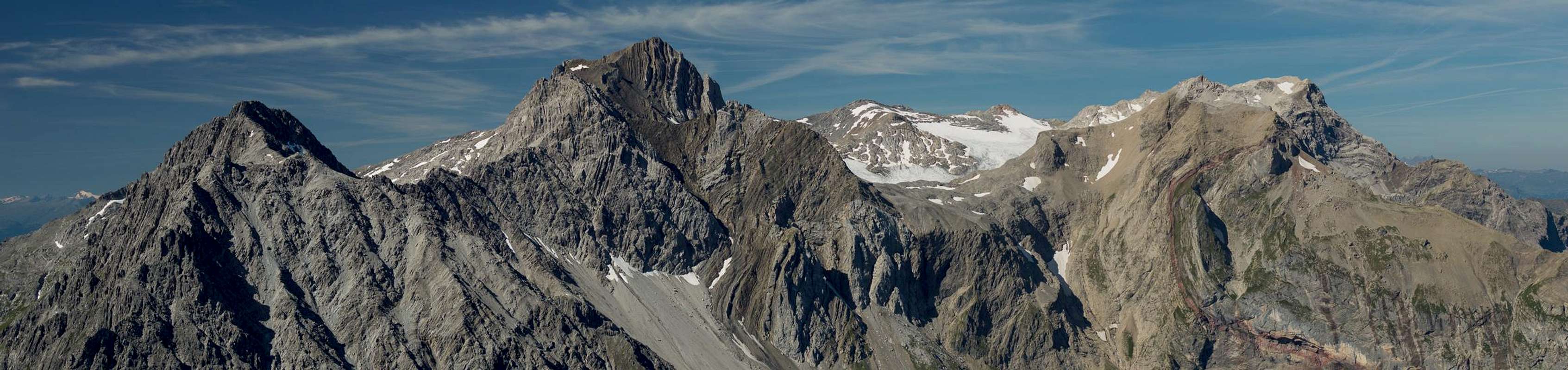
 Brandner Mittagsspitze and Saulakopf seen from Mottakopf Brandner Mittagsspitze and Saulakopf seen from Mottakopf |
The Rätikon Range, though it is rather small, appears to be rather complex even if you look at it from the inside. Vastly different rock composiition and the location on the border region of three countries, one of which (Liechtenstein) is so small that it fits inside the range helps this perception as no roads divide it but rather pass it on either side. The main ridge is short and subdivided into several very different subgroups while long side ridges run out into the valleys to the east and west.
 |  |  |
The longset and most impressive of these subgroups, the Zimba Group, also Valkastielkamm does not turn off from the main ridge proper but starts at Saulajoch, a saddle which separates it from the southern part of the Kirchlispitzen Group. The first summit above the saddle is Saulakopf, a broad limestone mountain rising up to 2517m. It connects to Brandner Mittagspitze across a high ridge which never significantly drops beneath 2500m but is separated from mighty Zimba by Zimbajoch. The closest mountain to the south is twin peaked Schafgafall, right across Saulajoch.
 |  |  |
Saulakopf is famous for its views, mainly those to the immediate vicinity: the impressive horn of Zimba is right tothe north-east while the Schesaplana Group is right on the opposite side of the turquoise Lünersee. The limestone bastions Sulzfluh, Drusenfluh and Kirchlispitzen, however, are partly hidden behind other summits. In addition, on a clear day you will be able to look far towards the groups of the Eastern Alps, between Platta Group and Ötztal Alps.
Summit panorama towards the Schesaplana Group
  |
Getting There
 The Lünersee Area from Saulakopf
Trailhead for Saulakopf is the cable-car to Lünersee at the end of Brandnertal. Most hikers start at Douglass Hut at the top of the cable-car but if you plan an additional 2h you can also hike the Böser Tritt path (protected) to the hut.
Brandnertal has its own exit on motorway A14 and is located directly opposite of the regional capital Bludenz. The motorway connects Bregenz on Lake Constance (and thus the border region between Switzerland, Austria and Germany) with Innsbruck across Arlberg Pass or Tunnel. Thus the area can be very easily reached. The cablle-car is right at the very end of the valley.
Routes
 Schesaplana Group from one of the protected sections on the normal route
Saulakopf is a popular mountain as it can be reached in a few hours from the Lünersee cable-car and Douglass Hut, which is located next to it. There are two hiking routes which combine in Saulajoch and even if you don't intend to climb to the mountain, the two routes can be hiked as a panoramic looop with little elevation gain and no difficulties.
 |  |  |
Saulakkopf itself can be reached by two routes, the hiking route throgh the west face and a Via Ferrata along the south-west pillar, which is very exposed. The normal route also has protected sections where it leads across exposed ledges. The crux is a polished slab about 50m beneath the summit which is tricky even with protection. The normal route is listed as a Via Ferrata in guidebooks of the region.
Red Tape
 |
There's no Red Tape here. One curiosity though: right at the start of Saulajochsteig there is a sign which seems to claim that it is closed. However, as far as I could make out, the sign only closed a short section of the path which lead to the pillar of a material lift to Douglass Hut. There is a shortcut bypassing this closed section.
Accommodation
Since Brandnertal is a well known ski area there is plenty of accommodation nearby. You can use the following link:www.brandnertal.at
Also, in Bürserberg, near the mouth of the valley, there is a campground if you are inclined this way.
Weather Conditions
Maps & Books
Maps
- Brandnertal / Nenzinger Himmel / Rätikon
1 : 35.000
WK 5374
Verlag Freytag & Berndt
ISBN: 978-3-7079-1275-3
- Montafon
1:25000
WK 032
Kompass Verlag
ISBN: 978-3-85491-614-7
Books
- Brandnertal
Herbert Mayr
Rother Verlag
ISBN: 978-3-7633-4035-4