
-
 5095 Hits
-
 79.78% Score
-
 11 Votes
|
|
Mountain/Rock |
|---|---|
|
|
47.06442°N / 9.76664°E |
|
|
Download GPX » View Route on Map |
|
|
Hiking |
|
|
Summer, Fall |
|
|
7920 ft / 2414 m |
|
|
Overview
 Schafgafall seen above Lünersee Schafgafall seen above Lünersee |
Schafgafall is one of the northernmost mountains of the Kirchlispitzen Group in the Rätikon Range. It is a twin-headed mountain with the northern summit, nördlicher Schafgafall reaching 2393m and the southern summit, südlicher Schafgafall reaching 2414m. They are separated by a steep notch, which thanks to the brittle composition of the mountain's rock is very difficult and dangerous to cross.
Both summits have high and steep west faces which dominate the eastern end of Brandnertal Valley. They also tower above the Lünersee Reservoir, one of the main tourist attractions in this part of Rätikon. A cable-car leads from the valley floor towards Douglasshütte, a hut on the banks of Lünersee. From here the normal route to the higher Schafgafall southern summit takes little more than one hour.
 From Gawalljoch From Gawalljoch |  From Saulakopf normal route From Saulakopf normal route |  From Douglasshütte From Douglasshütte |
The eastern sides of both summits are grass slopes across which the usual ascents run. The meadows are famous for their flora with many a rare fflower blooming there in late spring and early autumn. Schafgafall itself, though rather a lower mountain of Rätikon, nevertheless is one of its best lookout peaks. Its solitary position ensures faraway views towards the many mountain groups around (Alpstein, Bregenzerwald, Lechquellengebirge, Lechtal Alps, Allgäu Alps, Ferwall Group, Silvretta). Most famous, however are the closeup views towards Sulzfluh and Drusenfluh as well as Rätikon's highest mountain, Schesaplana with its satellites. And naturally the turquise eye of Lünersee attracts a lot of attention as well.
 Sulzfluh and Drusenfluh Sulzfluh and Drusenfluh | ||
 Nördlicher Schafgafall Nördlicher Schafgafall |  Zimba Zimba |  Schesaplana Group Schesaplana Group |
 Wildberg Wildberg |  Lünersee Lünersee |  Schesaplana Schesaplana |
Given the short ascent and famous view it is amazing that Schafgafall still is rarelly visited. The entry point to the normal route, though not actually hidden (two cairns mark it), is a bit tough to find and the route itself is extremely steep in some places. We could enjoy the views with nobody competing for the little space on top of südlicher Schafgafall.
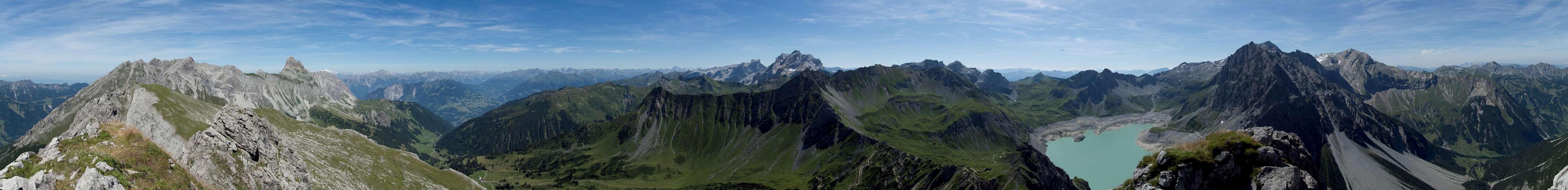
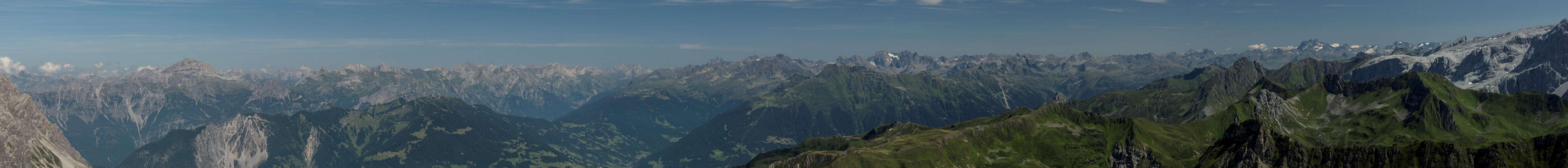
360° Summit Panorama
  |
Getting There
 Schafgafall seen from Mottakopf
Trailhead for Schafgafall is the cable-car to Lünersee at the end of Brandnertal. Most hikers start at Douglass Hut at the top of the cable-car but if you plan an additional 2h you can also hike the Böser Tritt path (protected) to the hut.
Brandnertal has its own exit on motorway A14 and is located directly opposite of the regional capital Bludenz. The motorway connects Bregenz on Lake Constance (and thus the border region between Switzerland, Austria and Germany) with Innsbruck across Arlberg Pass or Tunnel. Thus the area can be very easily reached. The cable-car is right at the very end of the valley.
Route
 |
The Ascent to Schafgafall from the Lünersee Cable-Car or Douglasshütte is a very short affair of little more than one hour. Just follow the lake promenade in clockwise direction. The broad trail ascends towards the intersection with the Lünerkrinne Path, which you have to follow. Several hundred metres after the intersection, after you have passed a rocky section to the left of the path two cairns mark the entry to the Schafgafall Route.
The route ascends very steeply through a narrow valley and finally uses the left hand slopes to reach a plateau. From the right a ridge joins the plateau from Lünerkrinne (some maps show a path across the ridge which is downright impossible to hike). Pass the plateau (a grassy knoll serves as lookout and resting place) towards the base of Südlicher Schafgafall. Here the steep and brittle ascent starts. Switchbacks take you across the south-east face to the top. Though there are cairns the route is ambiguous in its upper part. The summit only offers room for half adozen people.
If you can spare more than the two hours round trip for the direct ascent you can
- start at the parking lot in the valley and hike Böser Tritt, a protected trail to Douglasshütte and from there to Schafgafall as described above. Duration: 3.5h
- hike a loop around Schafgafall through Saulajoch and Lünerkrinne with a possible ascent to Saulakopf. Duration: 6 - 7h
Red Tape
 Campanula alpina Campanula alpina |  Gymnadenia conopsea Gymnadenia conopsea |  Phyteuma orbiculare Phyteuma orbiculare |
There's no Red Tape for Schafgafall. Even though some maps show an additional path to the mountain starting at Lünerkrinne it is not advisable to attempt it. It follows a very brittle ridge, which connects with the normal route and which is in a constant state of decay. It ends above a gap about 30m from the normal route which is very dangerous to descend into. Also, there is no easy way to circumvent it.
Accommodation
Since Brandnertal is a well known ski area there is plenty of accommodation nearby. You can use the following link:www.brandnertal.at
Also, in Bürserberg, near the mouth of the valley, there is a campground if you are inclined this way.
Weather Conditions
Maps & Books
Maps
- Brandnertal / Nenzinger Himmel / Rätikon
1 : 35.000
WK 5374
Verlag Freytag & Berndt
ISBN: 978-3-7079-1275-3
- Montafon
1:25000
WK 032
Kompass Verlag
ISBN: 978-3-85491-614-7
Books
- Brandnertal
Herbert Mayr
Rother Verlag
ISBN: 978-3-7633-4035-4