
-
 3852 Hits
-
 79.78% Score
-
 11 Votes
|
|
Mountain/Rock |
|---|---|
|
|
47.15253°N / 9.72674°E |
|
|
Hiking, Skiing |
|
|
Summer, Fall, Winter |
|
|
6453 ft / 1967 m |
|
|
Overview
 The Mondspitze south-west ridge seen from Schillersattel The Mondspitze south-west ridge seen from Schillersattel |
The Rätikon Range in Austria's smallest state Vorarlberg is famous for its limestone mountains like Sulzfluh, Drusenfluh or Kirchlispitzen as well as its highest summits around Schesaplana which almost reach an elevation of 3000m. From this main ridge several north-eastern side ridges run out into the valley of the river Ill. One of these ridges, wedged between Gamperdonatal Valley and Brandnertal Valley, is named after its most important summit the Fundlkopf Ridge. In itself it is also a famous spot as many of the Brandnertal ski runs are located on the ridge.
Before it runs out to some insignificant summits, the Fundlkopf Ridge kind of ends in two actual or near 2000ers, Schillerkopf (2006m) and Mondspitze (1967m). Connected by a long ridge across Schillersattel, both mountains couldn't be more different. While Schillerkopf is a limestone mountain with the typical towers, vertical walls, scree fields and even a huge doline (Kessiloch), Mondspitze is covered in firs and dwarf pines (Latschen) up to its very summit. Seen from the trailhead, Mondspitze looks like an almost perfect triangle, while actually it has a very steep north ridge and a long knife-edge south-west ridge towards Schillersattel.
 |  |  |
The routes towards Mondspitze follow these two ridges but due to the steepness of the former one it is rarely climbed. Rather, most people foloow the normal route through Schillersattel which includes the long panoramic south-west ridge. As mentioned above, the summit ridges are covered in dwarf pines, obstacles, which can pose serious difficulties on these exposed ridges. Here on Mondspitze the paths avoid the pines thus often leading out onto the south slopes of the mountain. The south-west ridge contains several summits of similar height, which thus get passed by while heading for the main one.
 |  |  |
Thanks to its position as north-easter outpost of the Rätikon Range above the Ill River Valley, Mondspitze offers far reaching views into the mountain ranges of the northern limestone Alps. Brgegenzerwaldgebirge, and Lechquellengebirge rise across the Ill River and beyond you can see the Allgäu Alps, Lechtal Alps as well as the Verwall- and Silvretta Groups. And to the north you will see Lake Constance, largest lake in the vicinity of the whole Alps.
Summit Panorama
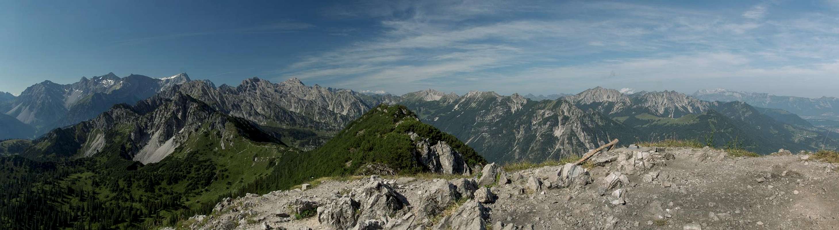
Summit view across the northern Rätikon Ridges
Getting There
 Mondspitze seen from Schillerkopf
Trailhead for Schillerkopf and Mondspitze is Tschengla Alm, which is located above the village Bürserberg, itself at the mouth of Brandnertal Valley. It is most easily reached by motorway A14, which connects Bregenz near Lake Constance with Innsbruck through the Arlberg Tunnel. Either of the ends of the motorway can be easily reached from Germany, Austria and Switzerland. Brand has an exit on the motorway and you have to go through Bürserberg to reach the village. In Bürserberg look out for signs to Tschengla. There are several parking lots along the road and near the Tschengla holiday village.
Routes
 |  |  |
There are two routes to the summit of Mondspitze. The regular normal route scrambles to Schillersattel, the col between Schillerkopf and Mondspitze, then follows the somewhat exposed south-west ridge of Mondspitze, mostly staying on its right-hand side.
The second route heads up to the summit from the north, across the forbiddingly steep north ridge. It is still a hiking route but an exposed and very strenuous one.
Red Tape
There is no red tape here. As you'll have to cross the pastures of Tschengla Alm and Rona Alpe, please make ssure to close all gates and (electrical) fences behind you. There are a lot of orchids on the upper parts of the routes (mainly gymnadenia conopsea), which are strictly protected. Leave them where they belong!Accommodation
Since Brandnertal is a well known ski area there is plenty of accommodation nearby. You can use the following link:www.brandnertal.at
Also, in Bürserberg, beneath Tschengla Alm, there is a campground if you are inclined this way.
Weather Conditions
Maps & Books
Maps
- Brandnertal / Nenzinger Himmel / Rätikon
1 : 35.000
WK 5374
Verlag Freytag & Berndt
ISBN: 978-3-7079-1275-3
- Montafon
1:25000
WK 032
Kompass Verlag
ISBN: 978-3-85491-614-7
Books
- Brandnertal
Herbert Mayr
Rother Verlag
ISBN: 978-3-7633-4035-4