
|
|
Route |
|---|---|
|
|
39.58280°N / 105.6681°W |
|
|
Scramble |
|
|
Most of a day |
|
|
Class 3 |
|
|
Approach
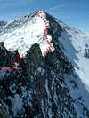
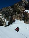
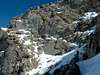
Route Description
 |  |  |  |  |
Essential Gear
 |  |
trashmoh1 - Aug 13, 2005 5:09 pm - Hasn't voted
Route Commenti just wanted to post that this is the easiest class three i've ever done. the exposure isn't that bad and the route finding is fairly easy. overall, i have to say that the hardest part of the sawtooth ,from bierstadt towards evans, is the downclimbing from bierstadt to the middle of the saddle. as long as the conditions are good this is a VERY do-able hike
BLong - Sep 25, 2011 7:44 pm - Hasn't voted
Nice hikeI might add that there is a fun variation to this hike to avoid the crowds on Bierstadt: park at the switchback at 13,000' on the Mt Evans road, drop ~800 feet down into the Abyss valley between Bierstadt and Evans, and then climb the easternmost arete of Bierstadt (which looks more vertical than it is. Lots of good 3rd class and some 4th class options). This leads to an easy hike up Bierstadt (check the 14ers.com photos to find a ramp around the 5th class moves on Point 13,641'). Then it's easy access to the Sawtooth, and a short hike back to your car.