


-
 4109 Hits
-
 78.27% Score
-
 9 Votes
|
|
Area/Range |
|---|---|
|
|
45.69680°N / 7.45656°E |
|
|
Hiking |
|
|
Spring, Summer, Fall, Winter |
|
|
5938 ft / 1810 m |
|
|
Note
La montagna chiama i suoi figli, ed essi rispondono fedelmente al suo appello… Osvaldo Cardellina, Diario alpinistico, 1964-65 Page texts: @ OsvaldoCardellina "Osva", passed away on May 2, 2022. Page owners: Christian Cardellina e Osvaldo Cardellina. Any updates from September 12, 2022: Antonio Giani, page administrator, friend and climbing companion. Testi della pagina: @ OsvaldoCardellina "Osva", scomparso il 2 maggio 2022. Proprietari pagina: Christian Cardellina e Osvaldo Cardellina. Eventuali aggiornamenti dal 12 settembre 2022: Antonio Giani, amministratore della pagina, amico e compagno di salite. |
Miners Overview
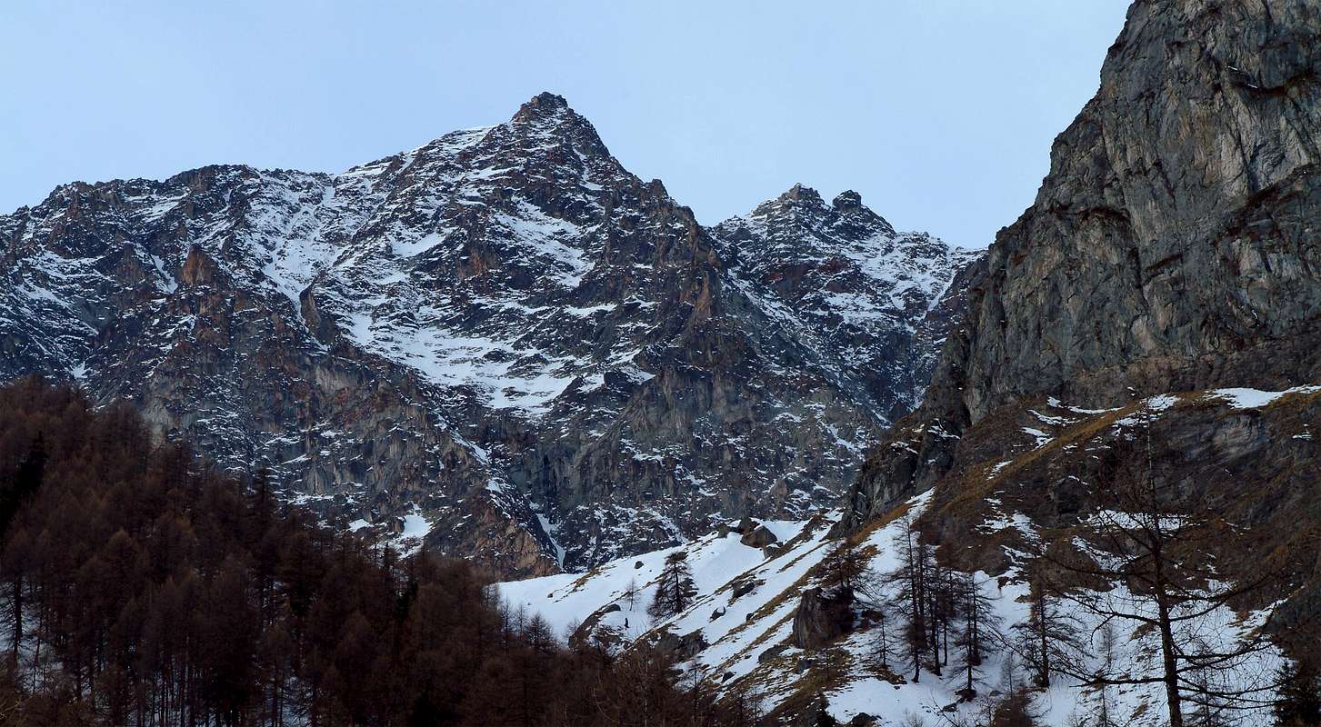
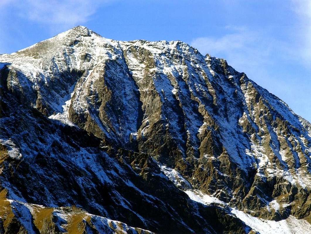
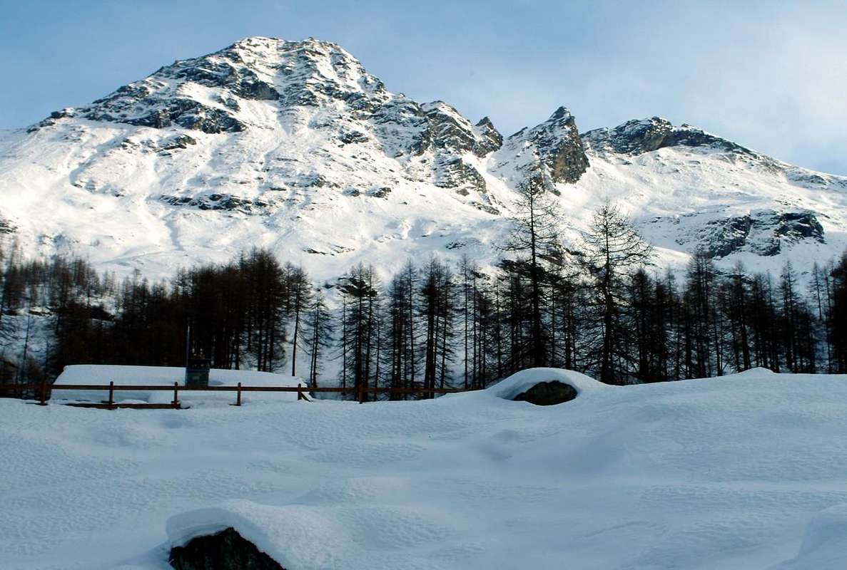
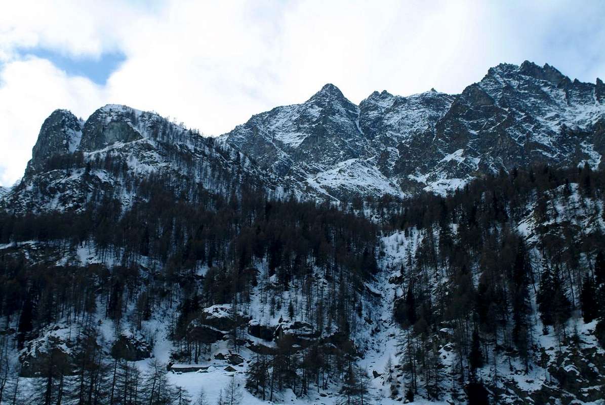
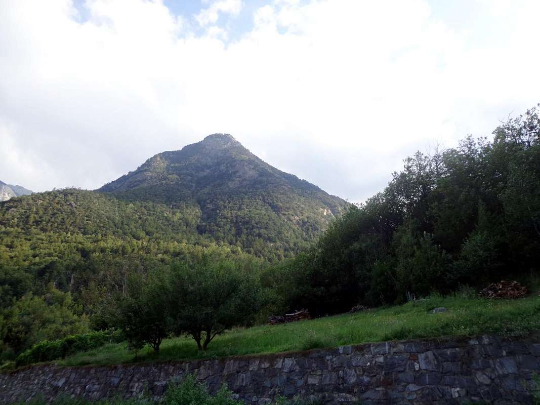
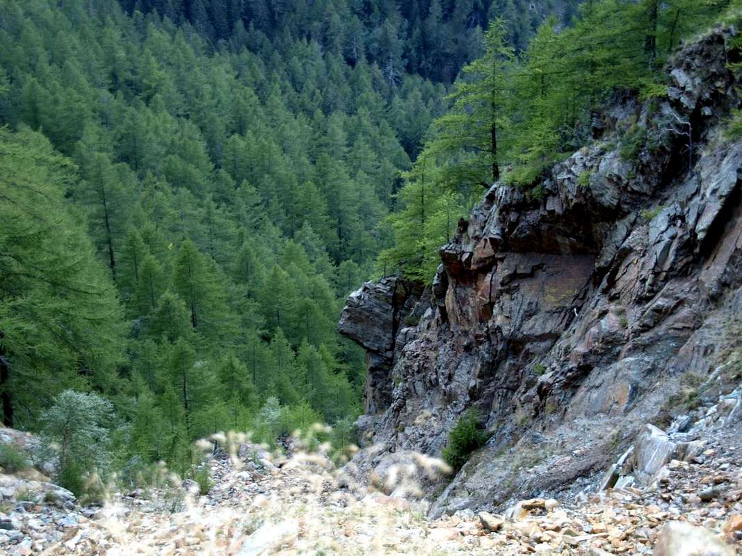
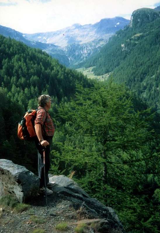
This specific mining area is located into the St. Marcel Vallon or Valley. This wide vallon dominates towards East the City of Aosta and falls in two Communes, also Fénis and St. Marcel. On top of that is made up of the Grande Roise small Mountain Chain (3.357m) on the more Western of the two watersheds that contain it. In fact this Summit is more deviated from the true Vertex of the valley formed by the Punta del Tessonet (3.266m), where the same ends forming two well defined watershed: the West precisely what the Subgroup of Rouèses, while on the opposite stretches that of two Averts, which culminates with the Grand (2.991m) to finally finish one hand to Mont Roux (2.271m) with the very ancient Iron and Coppermines of Chuc-Servette. While on the other, always after the Mont Corquet (2.531m), the partition is extended to the North-northeast until Torrasse or Mont Touriasse (1.985m) and the rocky promontory over the forest of Mont Saint Julien (1.377m), with its Sanctuary of San Grato above the Municipality of Fénis and the Hermitage of San Giuliano perched on the cliffs that dominate the entrance into the Clavalité Tableland. This vallon is unique in its development, starting from the valley floor near St. Marcel Common with its two fraction of Surpian or Sorpian (568m) and Prayer or Prarayer (566m), but actually splits the approach Regional Road that "escapes", "cutting" almost vertically up the hill to the North; reached the small Villages of Les Druges "Lower and Higher" (1.567m, 1.600m); then continue just to the North-northwest reaching Dora Baltea between the Fractions Tillier (550m; Fénis) and Valméanaz (601m; St. Marcel), right in front of the Commune of Nus across the Baltea Stream.
Questa specifica area sia mineraria che di protezione della natura é collocata nel Vallone o Valle di Saint Marcel. Quest'ampia valle domina il fondovalle ad Oriente della Città di Aosta ed incombe sui due Comuni di Fénis (Est) e Saint Marcel. Il vertice massimo della medesima é costituito dalla Grande Roise (3.357 m), sita sul più Occidentale dei due spartiacque contenenti la medesima. In realtà la Sommità risulta più lontana dal Vertice vero e proprio della valle costituito dalla Punta del Tessonet (3.266 m), ove la medesima termina formando due ben definiti spartiacque dei quali uno verso Occidente, appunto quello del Gruppo delle Rouèses, mentre sull'opposto si allunga quello degli Averts, culminante con il Grand Avert (2.991 m) per infine terminare da un lato al Mont Roux (2.271 m) con l'antichissime Miniere di ferro e rame di Chuc-Servette. Mentre dall'altro, sempre dopo il Mont Corquet (2.531 m), il divisorio s'allunga boschivo ad Ovest e roccioso e dirupato as Est, a Nord-nordest fino alla Torrasse o Mont Touriasse (1.985 m) ed al promontorio, roccioso-boschivo del Mont Saint Julien (1.377 m), con il suo Santuario di San Grato sopra l'abitato di Fénis nonché il famoso e pittosto frequentato Eremitaggio di San Giuliano abbarbicato alle pareti rocciose dominananti l'ingresso della sottostante ad Oriente Val Clavalité. La valle, unica nel suo sviluppo partendo dal fondovalle nei pressi di Saint Marcel, in realtà si sdoppia nell'avvicinamento stradale che "fuoriesce" dal suo percorso naturale; infatti la Strada Regionale risale più ad Oriente di questa linea, che segue il corso del Torrente di Saint Marcel, transitando per tutta una serie di villaggetti, con epicentro il rinomato Santuario di Plout (+; 968 m), posti sulla medio-alta collina alle pendici del Mont Corquet (+; 2.531 m), massima elevazione di questo settore inferiore sullo spartiacque e quasi al termine del medesimo che, come sopra detto, qui và sdoppiandosi. Anche i confini comunali con l'attiguo di Fénis risultano particolari e non seguono un preciso delineamento topografico, poiché non seguono lo spartiacque ad Est, bensì dal Mont Corquet s'indirizzano a valle "tagliando" quasi in verticale la collina verso Settentrione; raggiunti i piccoli Villaggi di Les Druges "Basse ed Alte" (1.567 m, 1.600 m), proseguono poi appena più a Nord-nordovest raggiungendo la Dora Baltea tra la Frazione di Tillier (550 m; Fénis) e quella di Valméanaz (601 m; St. Marcel), giusto di fronte al Comune di Nus oltre il fiume. This border demarcation, rather atypical and unusual in Aosta Valley, determines that the small Vallone of Pieiller, at the foot of Mont Saint Julien, belongs to the Municipality of Fénis and not more than that of Saint Marcel. Even the highest sector complaint an anomaly with a valley "hinted" that is directed towards Southeast reaching always at the foot of Mont Corquet the Alps Meyes, Plan-de Meyes, Bren and Praz-Premier or Prapremier (1.875m, 1.893m, 1.961m, 2.010m), all now in the former municipality, even though on this side of the divide. This factor means that, in order to gain access to the Valley of Saint Marcel real, must be by Les Druges "Alte" continue on the road, which becomes from paved to farm and private dirt road Westward reaching the Picnic Area (1.580m/1.630m about) and the subsequent Pastures of Pouria (1.586m) and Vargney, at a warehouse on the edge of the meadows. Continuing past is beyond the landfill of the mineral, turn decidedly in the South, entering into the walloon near the Mines of Chuc-Servette (1.591m), at the Eastern foot of Mont Roux. From this point the vallon, always with direction from North to South, after passing a small slope (gate with a sign indicating that the ban on driving) in the private Hunting Reserve Great Avert, currently owned by the Marquis Attilio Turati, already ex Reserve Baron Beck Peckoz Gressoney, runs the entire valley for about ten kilometres, passing the House Hunting Mulàc-St. Louis (1.937m), several pastures and ends in the South nearby the House Hunting Grande Chaux (2.370m) and Southeast Alp Petite Chaux (2.419m), the slopes of the two Averts and Lavòdilèc Hill (2.863m). From here continue to radiate the various paths that reach clockwise, beyond that hill, those of Tessonet (3.051m), St. Marcel or Coronas (2.913m), Vallonet (3.062m) and Leppe (3.110m), just after the Summit with the same name (3.305/6m) where do you get the beginning of Chain Grande Roise, that separating this vallon from that of adjoining Les Laures, ending above Grand Brissogne.
Questa demarcazione dei confini, piuttosto atipica ed inusuale in Valle d'Aosta, determina il fatto che il piccolo Vallone del Pieiller, ai piedi del Mont Saint Julien, appartenga al Comune di Fénis e non più a quello di St. Marcel. Anche la parte più elevata denuncia un'anomalia con un vallone appena "accennato" che s'indirizza verso Sudest raggiungendo alle pendici del Corquet le Alpi Les Meyes, Plan-de Meyes, Bren e Praz-Premier o Prapremier (1.875 m, 1.893 m, 1.961 m, 2.010 m), tutte ormai appartenenti al primo, anche se al di qua dello spartiacque. Questo fattore comporta che, onde poter accedere al Vallone di Saint Marcel vero e proprio, bisogna da Les Druges Alte continuare sulla strada, che da asfaltata diviene poderale, verso Ovest raggiungendo l'Area Pic Nic ed i successivi Alpeggi di Pouria (1.586 m) e Vargney, presso un magazzino con garages al limite dei prati. Proseguendo oltre si oltrepassano le discariche del minerale e, volgendo decisamente a Mezzogiorno, si entra nel vallone nei pressi delle Miniere di Chuc-Servette (1.591 m), alle pendici Orientali del Mont Roux. Da questo punto il vallone, sempre con direzione da Nord a Sud, dopo aver superato una piccola discesa (cancello con cartello segnalante il divieto di transito) nella privata Riserva di Caccia Grand Avert, attualmente di proprietà del Marchese Attilio Turati, già ex Riserva del Barone Beck Peckoz di Gressoney, percorre l'intera valle per una decina di Kilometri, passando la Casa di Caccia di Mulàc-St. Louis (1.937 m), diversi alpeggi per terminare a Sud alla Casa di Caccia di Grande Chaux (2.370 m) ed a Sudest all'Alpe di Petite Chaux (2.419 m), alle pendici dei due Averts e del Colle di Lavòdilèc (2.863 m). Da qui, proseguendo a raggiera, salgono i vari sentieri che raggiungono in senso orario, oltre a questo colle, quelli del Tessonet (3.051 m), St. Marcel od anche di Coronas (2.913 m), Vallonet (3.062 m) e di Leppe (3.110 m), subito appresso la Punta di Leppe (3.305/6 m), ove prende inizio la piccola Catena della Grande Roise che, separando il vallone dall'attiguo delle Laures, termina sopra Grand Brissogne.
![]()
The site dell'Éve or Eyve Verta or Green Water
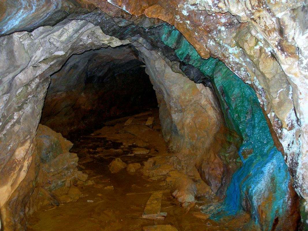
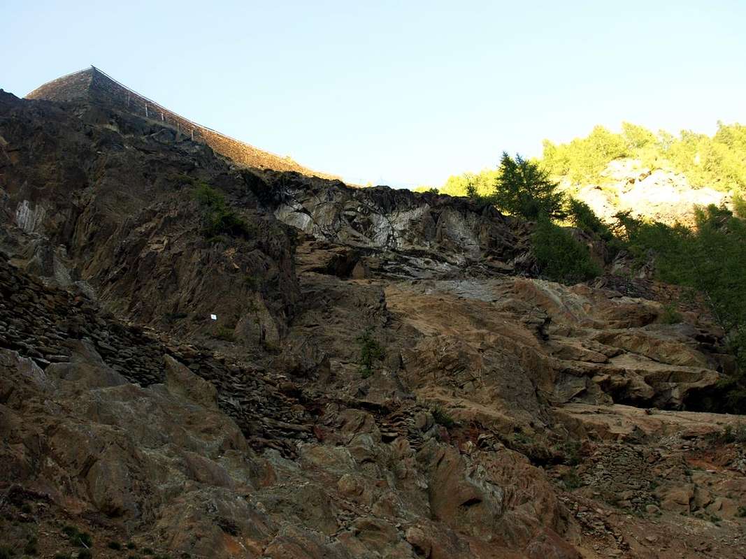
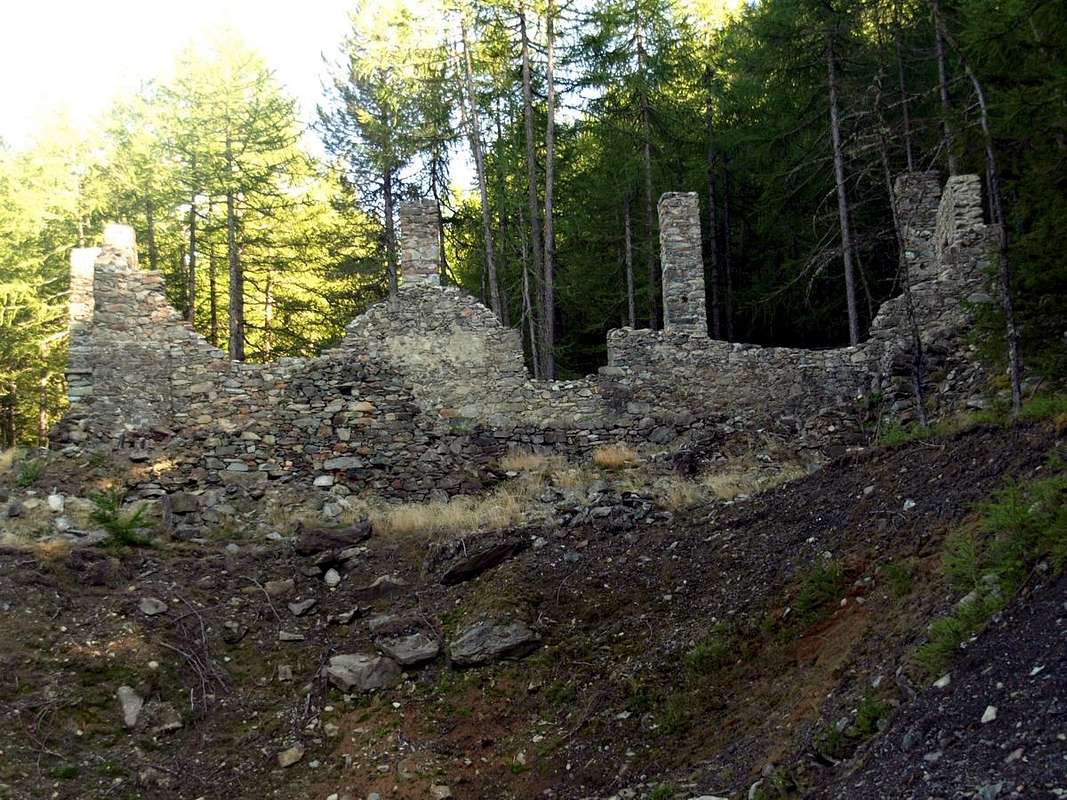
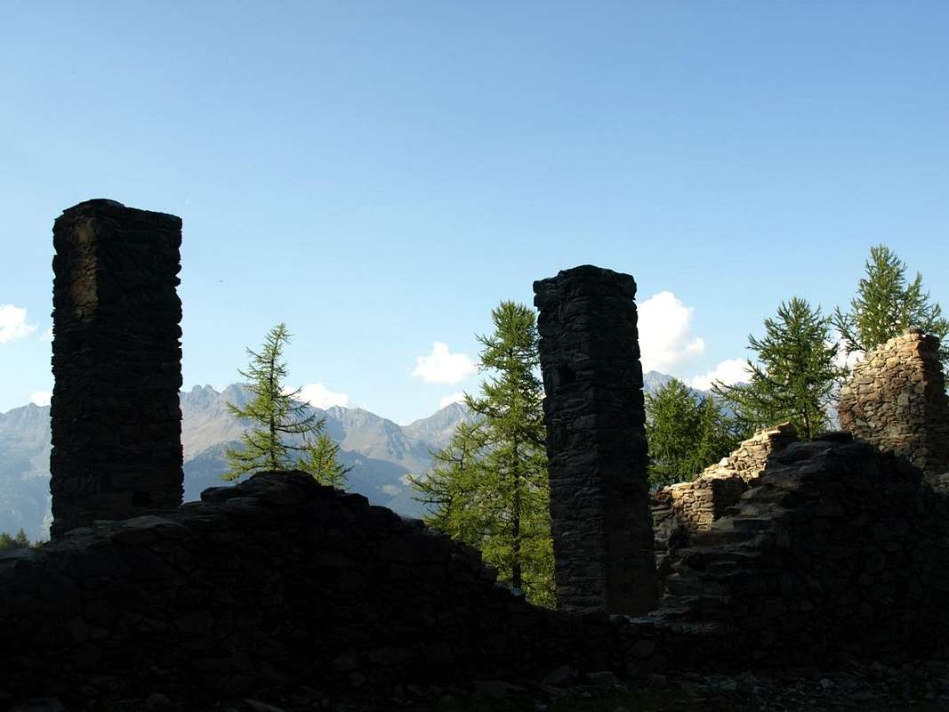
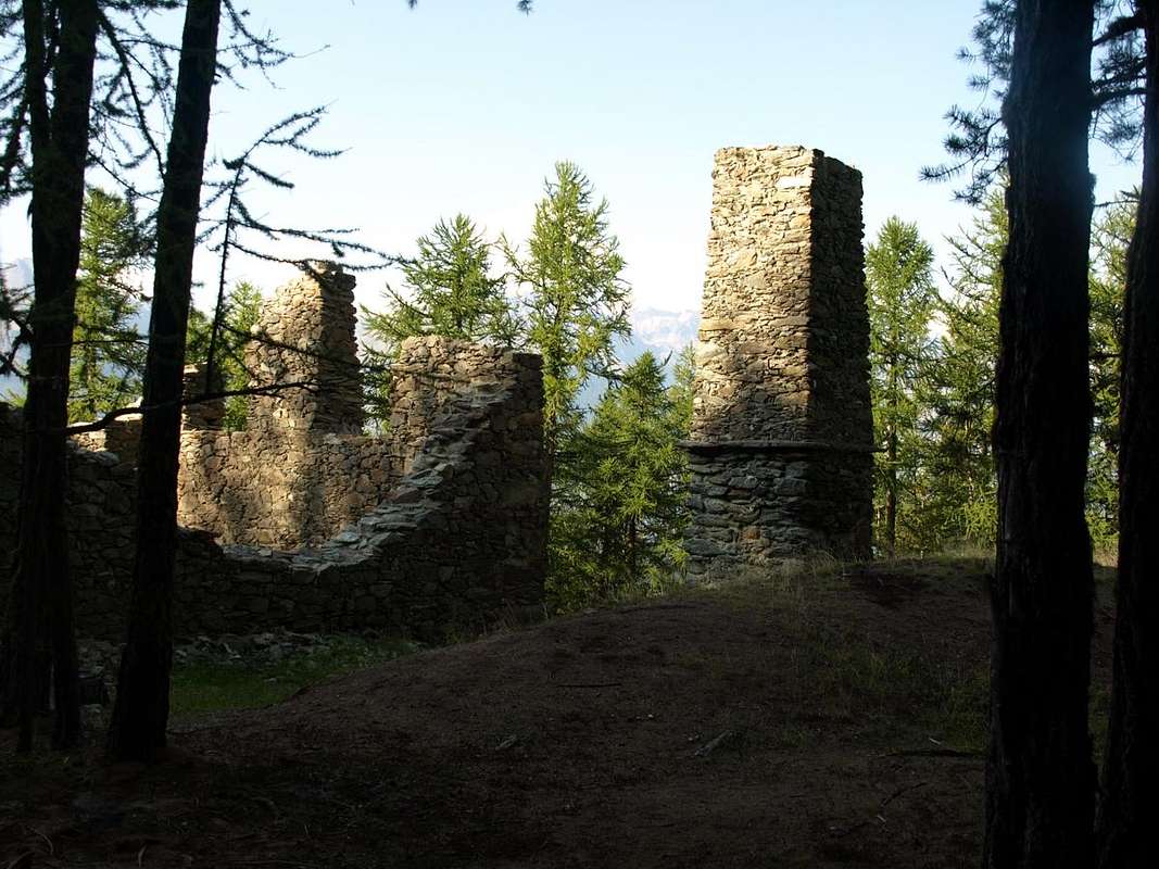
Dopo aver "inquadrato" il vallone, tra l'altro ricco oltre che di circa 100 stambecchi e 650 camosci, marmotte ed aquile, di numerose varietà di fiori tra le quali s'evidenziano le specie rare "Linnaea borealis e Clematis alpina" passiamo ad osservare le sue antichissime miniere ferro, rame e manganese che furon sfruttate, a volte in modo poco corretto, fin dall'epoca romana e probabilmente anche prima sin dal tempo dei Salassi. Numerose sono le tracce delle attività estrattive industriali nella parte medio-alta dello stesso con le miniere di Saint-Marcel, oggi non più attive e definitivamente chiuse dal 1957, che costituirono nei secoli scorsi un notevole sito industriale, quasi alla pari con quelle di Cogne (magnetite) e di La Thuile (carbone). Degli insediamenti restano le tracce lungo i sentierini all'interno del bosco sottostante al Mont Roux, oggi abbastanza frequentata meta di turisti ed escursionisti. All'interno della foresta si ritrovano forni e depositi di scorie, teleferiche in rovina, le baracche dei minatori e le antiche gallerie parzialmente crollate, nonché ormai ricoperte dalla vegetazione. I siti del complesso minerario di St. Marcel tuttora visibili (dall'esterno poiché l'ingresso si rivela impossibile od alquanto pericoloso) sono quelli di Praborna ("Prato della Buca", 1.900 metri circa) più in alto verso la Casa di Caccia di Mulàc-St. Louis e sul versante Occidentale verso la Grande Roise e di Servette e Chuc all'ingresso del vallone, dopo il pianoro del Villaggetto di Les Druges. Insieme ad altri minerali di manganese si estraevano la rodonite, la braunite e il rarissimo violano, ricercato dai collezionisti di minerali ma industrialmente del tutto inutilizzato, a Praborna. A Servette e Chuc si trovavano giacimenti ferrosi e cupriferi; in particolare, nel sito di Chuc s'estraeva la pirite per la trasformazione in rame, mentre a Servette si ricavava la calcopirite per la formazione dell'acido solforico e nella sottostante località di Fontillon (1.653 m; raggiungibile dal tornante prima di Champremier 1.383 metri con sentiero n° 3A, segnalato in marrone come "Fontanala, Fontillon", o da Seissogne 1.066 metri in direzione Sud-sudovest per mezzo d'un sentierino non numerato) la pietra per macine da mulino. Inoltre, più ad Est di questa località ed in direzione di Les Druges "Alte", con partenza da Plout collegamento diretto a Sud-sudest tramite sentiero n° 3 col Villaggio di Viplana (1.346 m), donde alla poderale tra le Alpi Pouria e Vargney (1.676 m).
Il sito dell'Éve o Eyve Verta o Acqua Verde
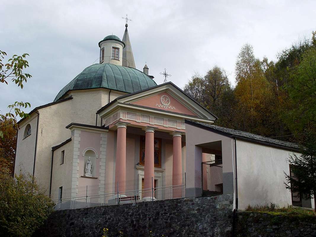
This vallon that, by extension and amplitude, deserves to be considered in all respects a valley, similar to those of Champdepraz or of the Lakes and Fénis-Clavalité High-Comba Tersiva, has many attractions ranging from the interest in Mineralogy and one for the naturalistic attractions, being a full-blown Reserve for over a Century and a half, even for those historical-religious-cultural in the medium-low hill, among which we highlight the famous Plout Sanctuary (968m; ample parking with a small fountain and other explanatory posters), a place of ancient Procession from Saint Marcel and numerous current visitations. The same is placed in the middle hill near the homonymous village, just beyond of that of Enchasaz, before the Regional Road in asphalt changes its direction from the Southwest to the East, reaching the Village Seissogne (1.066m) and other subsequent. But we will, both for him and for the part of the mineralogical and "Preserve of Grand Avert" or by Marquis Turati of Turin, more clarification in the next sections at regard to the first with its three mines of iron, copper and manganese and other minerals unimportant to industrial level, but certainly very interesting from the collecting point of view (Chuc, Servette, Praborna). These three mines are located on three different levels with the first and the last at about 1.400, 1.900 meters, and the second in an intermediate position in about 1.700, 1.920 meters above the area of Les Druges "High". The same are connected together by a series of mule tracks, trails or small paths that are based upon the common farm and private dirt road from Les Druges "Alte" goes the entire Valley of Saint Marcel first reaching the Mine Servette and then the House Hunting Mulàc-St. Louis (at the Mine Praborna) and then, after a consecutive series of pastures and the Lake Layet, the Gr. Chaux, important crossroads for all the hills above.
Questo vallone che, per lunga estensione ed ampiezza, merita d'esser considerato a tutti gli effetti una vera e propria valle, similarmente a quelle di Champdepraz o dei Laghi e di Fénis-Clavalité-Alta Comba Tersiva, possiede numerose attrattive che vanno dall'interesse per la Mineralogia, grazie alle numerose miniere che vi esistevano sino ad una sessantina d'anni orsono, ed a quello per le attrattive naturalistiche, essendo una Riserva conclamata ormai da oltre un Secolo e mezzo, a quello storico-religiose-culturali nella parte medio-bassa, tra le quali s'evidenzia il famoso Santuario di Plout (968 m; ampio parking con fontanella e diversa cartellonistica esplicativa), meta di antiche Processioni da Saint Marcel e di numerose attuali visitazioni. Il medesimo é collocato in media collina presso l'omonimo villaggio, subito appresso a quello di Enchasaz, prima che la Strada Regionale in asfalto cambi la sua direzione da Sudovest ad Est raggiungendo il Villaggio di Seissogne (1.066 m) ed altri successivi. Ma daremo, sia per quanto gli concerne che per la parte mineralogica e la "Riserva del Grand Avert" o Riserva del Marchese Attilio Turati di Torino nonché ex antica Riserva del Barone Giuseppe Antonio Beck Peckoz di Gressoney, maggiori delucidazioni nella successive apposite sezioni concernenti la prima con le sue tre miniere di ferro, rame e manganese, nonché altri minerali rari non tanto importanti dal punto di vista industriale quanto da quello collezionistico (Chuc, Servette, Praborna). Queste tre miniere sono collocate su tre livelli diversi con la prima e l'ultima a circa 1.400, 1.900 metri e la seconda in posizione intermedia sopra la zona di Les Druges "Alte". Le stesse son tra lor collegate da una serie di mulattiere o sentieri aventi base comune nella strada poderale che da Les Druges "Alte" risale lo intero Vallone di Saint Marcel raggiungendo dapprima la Miniera di Servette e poi la Casa di Caccia di Mulàc-St. Louis (presso le Miniera di Praborna) e quindi, dopo una serie consecutiva di alpeggi ed il Lago Layet, quella di Grande Chaux, crocevia importante per tutti i colli soprastanti ovvero del Grand Avert, di Terre Bleue, Lavòdilèc, Colletto del Tessonet, Col coronas o di Saint Marcel, Vallonet e Leppe.
Getting There
BY CAR:
- From TORINO, MILANO, etc: Motorway A5. Exit at IVREA or Quincinetto (PIEDMONT)
- From IVREA Town: in West (Southern side) to Pont Saint Martin, Donnas, Bard, Champdepraz, St. Vincent, Châtillon, Pontey, Fénis, Saint Marcel.
- From Fénis Commune (537m) on Pieiller small Vallon towards Le-Pieiller-de-Sermaz, Maison Longue, Le Plany Hamlets (1.075m, 1.112m, 1.174m); through asphalt road) and subsequent connection with La Morgetta(z), Pressunettaz, alternative before Champremier (1.383m) at Les Druges Lower and Upper small Villages (1.567m, 1600m).
- From Saint Marcel Commune (630m) to Saint Marcel Vallon and Turati Reserve up to the Mulàc and Grande Chaux Hunting Houses and Alp (1.937m, 2.370m). Specific Road By SS.26, 15 Km by Aosta Town, crossing the stonebridge over the Dora Baltea, just after the Country of Nus (output Motorways A5), arriving at the junction 539 meters, and immediately after the field of Football, leave the roundabout to the left on the same (various large signals), and go up to the Chief Lieu.
- From FRANCE: through the Mont Blanc Tunnel to Entrèves-crossroads to Vény/Ferret Valleys - Mountain Guides of Courmayeur - La Saxe Rock Gym - Courmayeur. By Little Saint Bernard Pass, closed since November until half May to La Thuile Valley - Pré Saint Didier - Courmayeur. It is not necessary to take Motorway A5: you can drive on SS.26, in the direction of AOSTA - IVREA - TURIN.
BY PLANE:
- Aeroporto "Corrado Gex" Saint Christophe (Aosta).
 |
 |
 |
 |
 |
Mines & Trails
After "framed" this vallon, among other rich as well as around 100 steinbocks and 650 chamoises, marmots and eagles, many varieties of flowers among which we highlight the rare species "Linnaea borealis and Clematis alpina" let us observe the its very old mines iron, copper and manganese were exploited, sometimes so little proper, since Roman times and probably before since the time of the Salassian People. Numerous traces of the mining industry in the upper middle of the valley with the mines of Saint-Marcel, which is no longer active, and finally closed in 1957, were in the past centuries a major industrial site, almost on par with those of Cogne Valley (magnetite or loadstone) and La Thuile (coal). Settlements remain traces along the small paths in the wood below the Mont Roux (2.271m), now quite popular destination for tourists and hikers. At the interior of the forest are ovens and waste repositories, cableways ruined cabins of the miners and the old tunnels partially collapsed and now covered by vegetation. The sites of the mining complex of St. Marcel still visible (from outside because the entrance is impossible or very dangerous, now closed) are those nearby Praborna Pasture (about 1.900 meters, "Prato della Buca") higher to the House Hunting Mulàc and on the Western slope towards the Great Roise Chuc and Servette and the entrance of the valley after the wide plateau of Les Druges Alte" or Upper. Along with other manganese ores mined the rhodonite, braunite and very rare to violate, by collectors of minerals but industrially completely unused, Praborna. In Chuc and Servette were deposits ferrous and cupriferi; in particular, in the site of Chuc he was extracted pyrite for the transformation in copper, while at Servette was extracted chalcopyrite for the formation of sulfuric acid and nearby the locality of Fontillon 1.653 m; reached from hairpin bend before the Village of Champremier 1.383 meters through trail n° 3A, reported in color brown as "Fontanala, Fontillon", or by Seissogne (1.066m) with a small path not numbered) the the special stones to build the grindstones for the production of flour mills operated by the course of the waters of torrent. In addition, further East of this location and towards the area of Les Druges "High", departing from Plout to the South-southeast by direct footpath n° 3 with the above Viplana Village (1.346m); this to the dirt road between the Alps Pouria Vargney (1.676m).
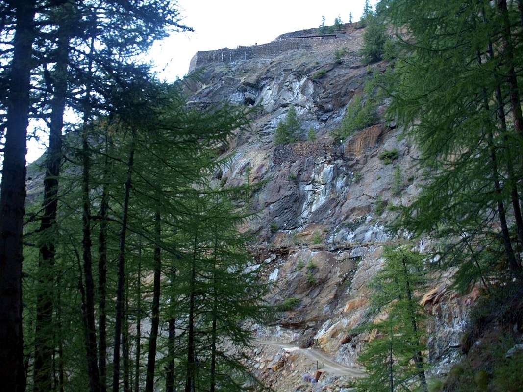
Climb along the entire vallon, in places L'Eyve or Éve Verta Verta or even (in Valle d'Aosta patois "Green Water"), about 1.290 meters, you meet a source of water from copper to green turquoise, the color of which gives its name to the locality (at about 1.200/50 meters and below the Chuc small Village) the particularity of which consists in the fact that water is rich in copper salts such to be covered with these colors the rocks, the soil and including mosses above the stones in which scrolling deposits a thin layer of woodwardite and other minerals and slag heaps characterized by impressive scale blue-green (malachite) or yellow-orange (iron hydroxides). Since March of 2013 it was approved by the Regional Council of the Autonomous Region of Aosta Valley a restoration project of the St. Marcel mines that will secure the sites in view of their tourist, cultural development; the same is still work in progress at present, ie in half of September 2015, where with different signs in yellow is currently banned the entry for evident precautionary reasons.
 |
 |
 |
 |
Salendo lungo il vallone, in località L'Eyve oppure Éve Verta od ancora Eyve Verta (in patois valdostano "Acqua Verde"), a circa 1.290 metri, si incontra una sorgente d'acque dal colore dal verde rame al turchese, la cui colorazione dà il nome alla località la particolarità della quale consiste nel fatto che l'acqua sia ricca di sali di rame tali da ricoprire con questi colori le rocce, il terrccio e compresi i muschi sopra le pietre, sulle quali, scorrendo, deposita un fine strato di woodwardite e d'altri minerali, nonché scorie di lavorazione caratterizzate da suggestive incrostazioni verde-azzurro (malachite) o giallo-arancio (idrossidi di ferro). Dal Marzo del 2013 è stato approvato dalla Giunta Regionale della Reg. Autonoma Valle d'Aosta un progetto di recupero delle Miniere di St. Marcel che metterà in sicurezza i siti in vista della loro valorizzazione turisitica e culturale; lo stesso risulta ancora in corso d'opera attualmente, ovvero Settembre 2015, dove con diversi cartelli segnaletici gialli viene vietato attualmente l'ingresso per evidenti motivi precauzionali.
Questa area in pratica è caratterizzata da tre fondamentali miniere, in grado di produrre ferro, rame e manganese con le relative trasformazioni industriali:
This area in practice is characterized by three fundamental mines, capable of producing iron, copper and manganese with the relative industrial change:
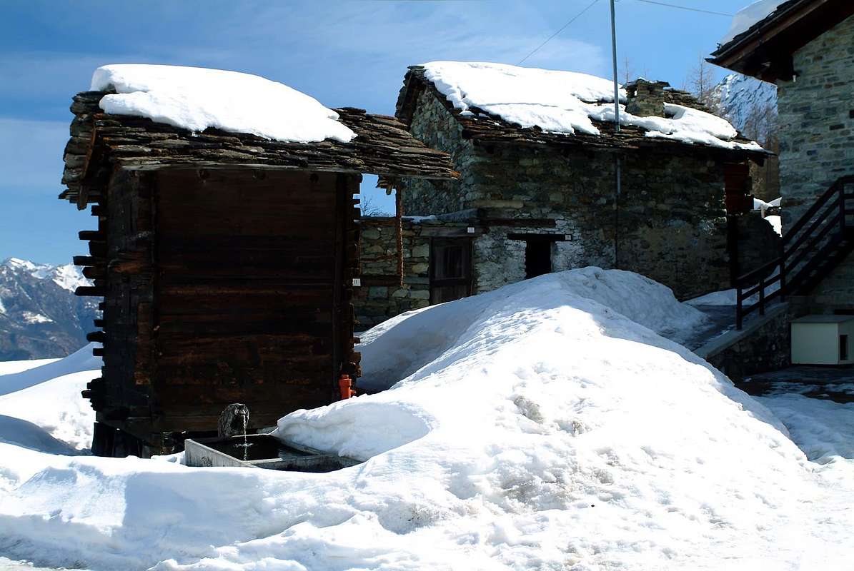
1) - Mine Servette, positioned between the altitudes 1.700 and 1.900 meters on the Northwestern Slope of Mont Roux (2.271m), an extreme offshoot of the North-northwestern Ridge of Mount Corquet (2.531m), which is evident, after the small saddle 2.260 meters, as robust and rounded wooded rocky promontory in the direction of the Vallon of Saint Marcel to the West-northwest on the localities of Servette, Chuc and Eteley (1.819m, 1.418m, 1.750m) and the plateau on which are placed Pastures Fontana Fredda (1.810m), Les Druges "Low, High" (1.567/1.600m), Pouria and Vargney (1.676m) to the North. By it, most likely until the times of the Salassians People, then the Romans were mined and processed iron and copper, almost definitely of the same strand of the next Group of Mount Avìc (Invers of Lago Gelato, Mounts Iverta Avìc, Rouvìc and Barbeston). But there is no certainty of this, although it is the logic to suggest it, even in relation to what happened in other mining sites in Valley of Aosta. Scientific studies on waste with dating radiocarbonio3 allege the end of the ninth Century the beginnings of draws with its ore processing then continued with ups and downs over the next until 1870/80, when the mine was first abandoned and then transformed turning machining no more the chalcopyrite to produce copper, but only to the pyrite used in the "Factory" in the valley foor at the bridge over the Dora Baltea to produce sulfuric acid and consequently fertilizers for agriculture, with transformation in the nearby Verrès Commune Establishment. A transformation that saw the end of merger activity in the kilns (important and currently being restored to Trèves in "Garages" location) with great impoverishment of forests due to excessive cutting of fir and red larch. He continued instead that of extraction, including that of the stone to build millstones for mills to flour in an activity started already from XI° Century. Surely this is to be like mine more productive and important of the three and, almost certainly, as the first to be discovered and exploited since ancient times.
 |
1) - Miniera di Servette, posizionata tra le quote di 1.700 e 1.900 metri circa sul Versante Nordoccidentale del Mont Roux (2.271 m), estrema propaggine della Cresta Nord-nordovest del Mont Corquet (2.531 m), che si evidenzia, dopo la selletta 2.260 metri, come robusto e tondeggiante promontorio boschivo roccioso in direzione del Vallone di Saint Marcel ad Ovest-nordovest sopra le località di Servette, Chuc ed Eteley (1.819 m, 1.418 m, 1.750 m) e dell'altipiano sul quale sono collocati gli Alpeggi di Fontana Fredda (1.810 m), Les Druges "Basse, Alte" (1.567/1.600 m), Pouria e Vargney (1.676 m) a Settentrione. Dalla stessa molto probabilmente sin dai tempi dei Salassi e poi dei Romani venivan estratti e lavorati ferro e rame, quasi sicuramente dello stesso filone del vicino Gruppo del Monte Avìc (Invers del Lago Gelato, Monti Iverta, Avìc, Rouvìc e Barbeston). Ma di ciò non esiste certezza, anche se è la logica a suggerirlo, in rapporto a quanto avvenuto negli altri siti minerari della Valle d'Aosta. Studi scientifici sulle scorie con datazione al radiocarbonio3 adducono alla fine dello IX° Secolo gli inizi dell'estrazioni con relativa lavorazione del minerale poi proseguiti con alterne vicende nei successivi fino al 1870/80, allorché la miniera venne prima abbandonata e successivamente trasformata rivolgendo la lavorazione non più alla calcopirite per produrre il rame, bensì esclusivamente alla pirite utilizzata nella "Fabbrica" a fondovalle presso il ponte sulla Dora Baltea per produrre acido solforico e di conseguenza concimi per l’agricoltura. Una trasformazione che vide terminare le attività di fusione nelle fornaci (importante ed attualmente in fase di restauro quella di Trèves in località "Garages") con grande impoverimento del patrimonio boschivo a causa dell'eccessivo taglio di abeti e larici rossi; continuava invece quella d'estrazione, compresa quella della pietra per costruire macine per i mulini a farina in un’attività iniziata già dal XI° Secolo. Risulta sicuramente come la miniera più produttiva ed importante delle tre e, quasi certamente, la prima ad esser stata scoperta e sfruttata già nell'antichità.
2) - Mine Chuc. Almost simultaneously in recent times but below, or between the 1.300/1.450 meters, in locality "Laveria" or Lavéry which was produced electricity and locations, as the word suggests, he came the ore to a first cleaning of the transfer by means of cable car route with more than 4 Kilometres carried him to the "Factory" in Saint Marcel. While the entrances of the Mine Servette are distributed to about half a mile wide and galleries of almost 300 meters, detectable at a higher altitude, those of Mine Chuc are located around the mining village of the same name (1.466m, reached by Villages Plout and Seissogne 968, 1.066 meters through the "Strada Cavour" and passing the locality Eve Verda 1.205/1.331 meters) to reach the altitude of almost 1.500 meters and have lenses of pyrite with five different levels and with galleries that profoundly affect the rock. The external structures and cableways, which Servette still exist even if they are collapsed, have been deleted from natural phenomena, not least the many floods of Torrent de Saint Marcel (1957 and 2001, the most important). Even this, and perhaps just in time for the same, he was totally abandoned with Servette own in 1957. Today, a complete restoration of the same by the Autonomous Region of the Aosta Valley (now that the site is prohibited with large yellow signs for the ongoing work) sees the reorganization of trails, made safe, with relative cableways buckets and sheaves for the transport of the mineral and of various constructions. Of the latter there are only a few buildings in ruins, while the new work propagate "in life" the sense that it was an old way of life of the miners, but also removes forever the charm of old who was survived into the old time. The inlets have been renovated and closed with iron gates and, as seen from the outside, spread a sense of sadness and melancholy. In these mines, including that of manganese Praborna, they were extracted daily about 20 tons of material. A Praborna mined rhodonite, braunite violate manganese and other minerals; to that of Chuc pyrite and chalcopyrite Servette. In the first galleries reached only 40 meters deep, as the manganese minerals were relatively the surface, while those of Chuc and Servette could be reached even 400 meters. The tools used consisted simply hammers compressed air, mine, shovels, pickaxes, helmets for head protection, acetylene lamps, lighting and rail trolleys for transportation outside of the extracted material. All this material was brought to the valley by cable car and continued the journey to Verres by trucks, where they were working in the chemical industry Brambilla and transformed into chemical fertilizers. Among workers, employees and executives, it was reached number forty-eight people to work eight hours a day divided into two shifts (from 6h'00 14h'00 to and from the 14h'00 22h'00), for six days week and six days a year of paid leave and to cover compensation in the event of illness or accident. Some workers came from Saint Marcel, others, especially the miners, came from the Provinces of Bergamo, Brescia or Venice. These lived in the Chuc and Lavery; the workers of Saint Marcel reached instead every night their homes, of course walk. In two premises provided by the company, the workers ran a small table and one of them went out early from work to prepare hot meals and warm up the food brought by the workers of the place below. The free time was spent playing cards cards or bocce; there was no radio and TV, going down occasionally to small Villages Seissogne and Plout or down to Saint Marcel to spend the evening in the bar with friends. Unfortunately they are also recorded two fatalities at work, namely the miners "valdostani" Roger Denchasaz and Remo Droz. So in the memories of Mr Giuseppe Chasseur, born in Champdepraz, a country well known mines, in 1909 and moved to Saint Marcel in 1938 to perform the duties of chief overseer of the Mines Saint Marcel.
 |
 |
 |
 |
2) - Miniera di Chuc. Quasi simultaneamente a quest'ultimo periodo ma leggermente più in basso, ovvero tra i 1.300/1.450 metri, in località "Laveria" o Lavéry dove veniva prodotta energia elettrica, nonché, come dice la parola, arrivava il minerale per una prima pulizia prima del trasferimento per mezzo di teleferica che con percorso di oltre 4 Kilometri lo trasportava alla "Fabbrica" in Saint Marcel. Mentre gli imbocchi della Miniera di Servette sono, distribuiti per circa mezzo Kilometro di larghezza e con gallerie di quasi 300 metri, rilevabile ad un’altitudine più elevata, quelli della Miniera Chuc si trovano intorno al Villaggio minerario omonimo (1.466 m; raggiungibile dai Villaggi di Plout e Seissogne 968, 1.066 metri tramite la "Strada Cavour" e passando dalla località Eve Verda 1.205/1.331 metri) raggiungendo l’altitudine di quasi 1.500 metri e presentano lenti di pirite con cinque differenti livelli e con gallerie che profondamente fendono la roccia. Le strutture e teleferiche esterne, che a Servette esistono ancora anche se ormai crollate e dabbasso rovesciate, sono state cancellate da fenomeni naturali, non ultime le numerose alluvioni del Torrent de Saint Marcel (1957 e 2001 le più importanti). Anche questa, e forse proprio in concomitanza delle medesime, è stata totalmente abbandonata insieme a Servette proprio nel 1957. Oggigiorno un'opera completa di ristrutturazione della medesima da parte della Regione Autonoma della Valle di Aosta (attualmente la frequentazione del sito é vietata con grandi cartelli gialli per i lavori in corso) vede la risistemazione di sentieri, messi in sicurezza, teleferiche con relative benne e carrucole per il trasporto del minerale nonché delle varie costruzioni. Di queste ultime rimangono solo alcuni edifici in rovina, mentre la nuova opera riporta "in vita" quella che era un vecchio modo di vivere dei Minatori, ma altresì toglie per sempre il fascino dello antico che prima sopravviveva al tempo. Gli imbocchi sono stati ristrutturati e chiusi con cancelli in ferro e, così visti dallo esterno, danno un senso di tristezza e di malinconia. In queste miniere, compresa quella di manganese di Praborna, venivano estratti giornalmente circa 20 tonnellate di materiale. A Praborna si estraevano rodonite, braunite, violano e altri minerali di manganese; in quella di Chuc la pirite ed a Servette la calcopirite. Nella prima le gallerie raggiungevano solo 40 metri di profondità, in quanto i minerali di manganese trovavansi relativamente in superficie, mentre a quelle di Chuc e Servette potevano essere raggiunti anche i 400 metri. Gli attrezzi da lavoro utilizzati consistevano semplicemente in martelli ad aria compressa, mine, pale, picconi, elmetti per la protezione della testa, lampade ad acetilene, per l'illuminazione e carrelli su rotaia per il trasporto all'esterno del materiale estratto. Tutto questo materiale era portato a valle per mezzo di teleferica e proseguiva il viaggio verso Verrès tramite camions, dove avveniva la lavorazione presso l'industria chimica Brambilla e trasformato in concimi chimici. Tra operai, impiegati e dirigenti, veniva raggiunto il numero di quarantotto persone per un lavoro d'otto ore al giorno suddiviso in due turni (dalle 6h'00 alle 14h'00 e dalle 14h'00 alle 22h'00), per sei giorni consecutivi alla settimana e con sei giorni all'anno di ferie retribuite e copertura da indennità in caso di malattia o d'infortunio. Alcuni operai provenivano da Saint Marcel, altri, soprattutto i minatori, provenivano dalle Province di Bergamo e Brescia o dalle Venezie. Questi abitavano al Chuc e a Lavéry; gli operai di Saint Marcel raggiungevano invece ogni sera le lor case, naturalmente a piedi. In due locali messi a disposizione dalla Ditta, gli operai gestivano una piccola mensa: uno di loro usciva anticipatamente dal lavoro per preparare dei pasti caldi e per riscaldare le vivande portate appresso dagli operai del posto. Il tempo libero veniva trascorso giocando alle carte oppure a bocce; non esistevano radio e televisione, scendendo di tanto in tanto ai Villaggi di Seissogne e Plout o giù fino in Saint Marcel per trascorrere la serata nei bar con gli amici. Purtroppo vengono registrate anche due vittime sul lavoro, ovvero i minatori valdostani Roger Denchasaz e Remo Droz. Così nei ricordi del Sig. Chasseur Giuseppe, nato a Champdepraz, un paese che ben conosce le miniere, nel 1909 e trasferitosi in quel di St. Marcel nel 1938 a svolger mansioni di sorvegliante capo delle vicine miniere.
3) - The Mine manganese Praborna ("Prato della Buca"). As for the manganese mine, there are records of its existence in a deed of 10 May 1415 between Francesco, first Earl of Challant permission of Duke Amedeo VIII° of Savoy, after the death of Ibleto February 10th, 1410, and the sons of Pietro of Challant. Due to the absence of documentation it is not possible to know the story of mining in the Fifteenth and Sixteenth Century, while with certainty is known that in the 1400 the research of the underground were handled by German entrepreneurs, while in the Thirteenth Century simultaneously in territory the Savoy they were handled by miners who came from Tuscany. At the beginning of the XVI° Century activities are entrusted to the gentlemen Savoyards. Important information, qualified and reliable is contained in the lengthy report drafted in 1756 by the Knight Nicolis di Robilant which contains information on the places and the history of mining in the Valle d'Aosta. Also in the third vol. the "Memoires de l'Academie des Sciences de Turin, année 1786/87", shows the tables relating to copper engravings, concerning the mines of Valle d'Aosta, and especially of those of Saint Marcel. Even more certain that this mine, simultaneously Chuc and Servette, ceased its activities in 1957. This mine, located approximately 1.900 meters just above and to the Southwest of the eponymous mountain pasture (1.882m), and at the Eastern foot of the Petite Roise (3.273m) into the Grande Roise Mountain Chain (3.357m), was exploited, incidentally as the others in the area, primarily by Salassian People and Romans then have a history quite similar. Presents, in his training "manganesifera" (of manganese) probably unique in the world of minerals or almost only in Aosta Valley as alurgite (variety of muscovite with manganese), the romeite (antimony of calcium with manganese), braunite, pyrolusite or polianite (mang. dioxide), the rhodochrosite (mang. carbonate), the marceline (local variety of rhodonite (mang. silicate), piemontite, gold on matrix urovite, titanite crystals, especially the violet-purple "violano" (diopside manganese) since, as the term implies, purplish color and so dear to mineral collectors.
 |
3) - La Miniera di manganese di Praborna (Prato della Buca). Per quanto riguarda la miniera di manganese, si ha notizia della sua esistenza in un atto notarile del 10 Maggio 1415 tra Francesco, primo Conte di Challant su concessione del Duca Amedeo VIII° di Savoia, dopo la morte di Ibleto il 10 Febbraio 1410, ed i figli di Pietro di Challant. A causa dell'assenza di documentazione non è possibile conoscere le vicende dello sfruttamento minerario tra il XV° ed il XVI° Secolo, mentre con certezza é risaputo che nel Quattrocento le ricerche del sottosuolo furono affidate a imprenditori tedeschi, mentre nel Duecento simultaneamente in territorio dei Savoia esse erano affidate a minatori che venivano dalla Toscana. All'inizio del XVI° Secolo le attività vengono affidate a dei gentiluomini Savoiardi. Un'informazione importante, qualificata e certa é contenuta nella lunga relazione redatta nel 1756 dal Cavalier Nicolis di Robilant nella quale son contenute notizie sui luoghi e sulla storia delle miniere della Valle d'Aosta. Inoltre nel III° vol. delle "Mémoires de l'Académie des Sciences de Turin, année 1786/87", sono riportate delle tavole relative ad incisioni in rame, concernenti le miniere della Valle d'Aosta, ed in special modo di quelle di Saint Marcel. Ancor più certo che questa miniera, simultaneamente a quelle di Chuc e Servette, cessò la sua attività nel 1957. Questa miniera, collocata a circa 1.900 metri appena sopra ed a Sudovest dello omonimo alpeggio (1.882 m), nonché alle pendici Orientali della Petite Roise (3.273 m) nel Gruppo delle Rouèses, venne sfruttata, come daltronde le altre in zona, primariamente da Salassi e Romani per poi avere una storia abbastanza analoga. Presenta, nella sua formazione manganesifera probabilmente unica al mondo, dei minerali presenti solo o quasi in Valle di Aosta come la alurgite (varietà di muscovite con manganese), la romeite (antimonio di calcio con manganese), la braunite, la pirolusite o polianite (biossido di manganese), la rodocrosite (carbonato di manganese), la marceline (varietà locale di rodonite (silicato di manganese), piemontite, oro su matrice di urovite, cristalli di titanite e soprattutto il "violano" (diopside manganesifero) dal, come dice il termine, colore violaceo e tanto caro ai collezionisti di minerali.
Base Paths
From Les Druges "Alte" (Upper) towards Praborna Manganesemine nearby Mulàc. Deliberately by choice, here we limit the description to the base path, which passes close to the mines by returning the most specific information in relation to small paths leading to the houses of the miners and the entrances to a subsequent specific page.
Da Les Druges "Alte" verso la Miniera di manganese di Praborna presso la Casa di Caccia di Mulàc. Per scelta voluta, limitiamo qui la descrizione al percorso di base, che passa nelle vicinanze delle miniere rinviando quella più dettagliata nei confronti dei sentierini adducenti alle case dei minatori nonché agli imbocchi a successiva specifica pagina.
From Les Druges Upper towards Servette, Praborna & Mulàc
 |
 |
 |
By Les Druges towards Grande Chaux: By Les Druges "Low" (1.567m) a last bend in the road asphalt leads to the "High", where shortly afterwards becomes paved farm road not more (signs in brown at the last house). From Les Druges "Alte" suddenly into the forest leads to the Picnic Area beyond which a short descent leads to the cartel prohibition for the cars just before the Pouria Pasture (1.586m; no more than three cars). Continuing uphill the private dirt road reaches, with soft ascent, a grassy esplanade at the edge of the forest with to the North an ancient ruined alp and in South the construction known as "Garages" below the ruins of the "Trèves Furnace", just before the fork in the torrent (still many yellow signs up at the furnace in left and down at Viplana Village in right (1.346m) with path n° 3). Continuing on the farm road to the West through a long diagonal leading to the location Vargney (1.676m) at some dumps of ore burned. Leave South the small path n° 16/18 addressed to the Coppermine of Servette and then to Lavanche Pasture (2.071m; suggestive way to transport the mineral with high stone walls and connecting with the Mines Praborna) and Crotey Dèsott Alp (2.348m), under Mont Corquet (2.531m). Starting from the small and last lay-by beyond the rocky-wooden dump of the above abandoned Coppermines Chuc-Servette, and after rounding the cape entering the real vallon, walk, instead through the trail n° 15 concomitant with the dirt road, "suspended" on the left (East) along the entire Vallon St. Marcel. A short descent leads to the base of a small trickle of water (not drinking dirty because with the sour taste of soil and copper) with the foot a rocky escarpment that rushes to the Torrent de Saint Marcel. Keep going towards South flexing a little to the right (South-southwest) with beautiful views of the overlying dry stone walls and the stone buildings designed to house the miners. Pass a new short ascent with beautiful views of the Group of Rouèses and wild Vallon Arpisson; another descent, after leaving to the left (East) deviation n° 16 for Servette, leading to the end of the same. After passing a small gate (signals of private property and border of the Reserve by Marquis Turati of Turin ex Baron Giuseppe Antonio Beck Peckoz of Gressoney) and after a short descent bypassing Eteley Pasture (1.750m) and abandoning Northwest the crossroads with path n° 4G towards the Alp Choulet and Arpisson Vallon, remount passing through Mulàc Hunting House (1.937m; beautiful fountain with wooden steinbock) boarding on the right (Northwest) the ancient Manganesemine of Praz Bornaz also Prabor(g)na, reached from alternative 1.836 meters through deviation not numbered and abandoned for years now (1.882m; E/F; 2h'00/2h'30). This must be considered the Basic Itinerary from which branch all variants for Mines Servette and Praborna, they exclude the Mine Chuc. This can be achieved by starting from Hamlets Plout and Seissogne or down by two forks (one, the first in ascent, reported) located between the localities Servette and Eteley. Da Les Druges "Alte" verso Servette, Praborna & Mulàc
Da Les Druges "Basse" (1.567 m) un ultimo tornante della strada in asfalto conduce a quelle "Alte", dove poco appresso diventa strada poderale non più asfaltata (cartelli in colore marrone presso l'ultima casa). Da Les Druges "Alte" un tratto nella foresta conduce all'Area Pic Nic, oltrepassando la quale una breve discesa conduce al cartello di divieto per i mezzi appena prima della località Pouria (1.586 m; non più di tre posti auto). Continuando in leggera salita la strada poderale raggiunge una spianata erbosa ai limiti della foresta con a Settentrione un'antica alpe diroccata ed a Sud una costruzione cosiddetta "Garages" appena prima della biforcazione del torrente (ancora vari cartelli gialli, in alto in direzione della soprastante Fornace Trèves" nonché delle abitazioni dei minatori ed in basso verso il Villaggetto di Viplana (1.346 m) con sentiero n° 3). Continuando sulla poderale verso Occidente un lungo diagonale porta alla località Vargney (1.676 m) presso alcuni piazzali sovrastati dalle discariche del minerale combusto. Lasciare a Sud il sentierino n° 16/18 indirizzato dapprima alla Miniera di Servette e poi agli Alpeggi Lavanche (2.071 m; suggestiva strada per il trasporto del minerale con alte mura in pietra su di un ponticello e collegamento con le Miniere di manganese di Praborna) e Crotey Dèsott (2.348 m)), con percorso sempre al di sotto del Versante Occidentale del Mont Corquet (2.531m). A partire dalla piccola piazzola al di là dell'ultima discarica dell'abbandonata miniera di rame Chuc-Servette, e dopo aver doppiato il promontorio roccioso-boschivo entrando nel vero e proprio Vallone di Saint Marcel, invece tramite il sentiero n° 15 concomitante alla poderale, camminare "sospesi" sulla sinistra (Est) lungo l'intera valle. Una breve discesina conduce alla base di un rivoletto d'acqua proveniente dalle miniere di rame (non bere perché sporca di terriccio e con il sapore acidulo del rame) con ai piedi una scarpata rocciosa precipitante verso il Torrent de Saint Marcel. Proseguire ancora verso Mezzogiorno flettendo un poco più a destra (Sud-sudovest) con bella vista sui soprastanti muraglioni di pietra costruiti a secco e sulle abitazioni in pietra atte ad alloggiamento dei minatori. Superare una nuova breve risalita con bella vista sulla Catena delle Rouèses e sul selvaggio Vallone di Arpisson; un'altra discesa, dopo avere lasciato a sinistra (Est) la deviazione n° 16 per le Miniere di Servette, porta al termine dell'area medesima. Dopo aver superato un cancelletto (segnalazioni di proprietà privata e confine della Riserva di proprietà del Marchese Attilio Turati di Torino, nonché ex Riserva di proprietà del Barone Giuseppe Antonio Beck Peckoz di Gressoney) e dopo una breve discesa superando l'Alpe di Eteley (1.750 m) e lasciando a Nordovest il bivio con sentiero n° 4G per l'Alpe Choulet ed il Vallone d'Arpisson, rimontare passando affianco alla Casa di Caccia di Mulàc (1.937 m; bella fontana con stambecco in legno), con immediatamente sulla destra (Nordovest) l'antica miniera di manganese, raggiungibile dal bivio con deviazione non numerato ed abbandonata ormai da molto, di Praz Bornaz o Praborna od ancora Praborgna (1.882 m E/F; 2h'00/2h'30). Questo deve esser considerato l'Itinerario di base dal quale si dipartono tutte le varianti per le Miniere di Servette e Praborna, esclusa quindi quella di Chuc. Quest'ultima può esser raggiunta partendo dai Villaggi di Plout e Seissogne oppure in discesa dai bivi consecutivi (uno segnalato) collocati tra le località di Servette e d'Eteley.
 |
Mountain Condition
- You can get meteo information at the official site of the Regione Valle d'Aosta:
- Valle d'Aosta Meteo
Important Information
- REGIONE AUTONOMA VALLE D'AOSTA the official site.
- FONDAZIONE MONTAGNA SICURA Villa Cameron, località Villard de la Palud n° 1 Courmayeur (AO) Tel: 39 0165 897602 - Fax: 39 0165 897647.
- A.I.NE.VA. (Associazione Interregionale Neve e Valanghe).
Useful numbers
- Protezione Civile Valdostana località Aeroporto n° 7/A Saint Christophe (Ao) Tel. 0165-238222.
- Bollettino Meteo (weather info) Tel. 0165-44113.
- Unità Operativa di Soccorso Sanitario Tel. 118.