
-
 9623 Hits
-
 82.48% Score
-
 15 Votes
|
|
Area/Range |
|---|---|
|
|
40.23892°N / 5.4221°W |
|
|
Hiking, Mountaineering, Trad Climbing, Sport Climbing, Ice Climbing, Big Wall, Mixed, Scrambling, Skiing |
|
|
Summer, Fall, Winter |
|
|
8501 ft / 2591 m |
|
|
1 - Overview
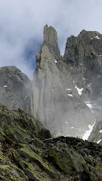
 Circo de Gredos as seen from Morezon Circo de Gredos as seen from Morezon |
Sierra de Gredos is part of the Sistema (also Cordillera) Central, the 500km long cluster of mountain ranges in Central Spain, which kind of divides the Iberian Peninsula in two. It is the highest, largest and generally most important of the subranges of Sistema Central with Almanzor (2591m) the highest mountain. The range stretches for roughly 140km between Cerro Guisando in the east and Rio Alagón in the west. It belongs to three provinces (Ávila, Salamanca and Cáceres). Geographically it is usually divided into three parts
- Macizo Oriental (east of Puerto del Pico). Its highest mountain is Sierra de Cabezo (2190m), itself a massif of several summits.
- Macizo Central (between Puerto del Pico and Puerto de Tornavacas). Here the most important mountains can be found in the vicinity of Circo de Gredos. Almanzor (2591m) can be found here.
- Macizo Occidental or Sierra de Bejar (north-west of Puerto de Tornavacas). Not as rugged as Macizo Central, Sierra de Bejar still reaches more than 2400m. Its highpoint is Canchal de la Ceja (2425m).
 |  |  |
Sierra de Gredos forms a big barrier between two plateau-like plains, the northern and southern mesestas. Both plateaus differ in up to 1000m in elevation, so that weather, flora and fauna are very different on both sides of the mountain range. Also, climbing and hiking in Sierra de Gredos you need to make sure from where you start as there might be elevation differences between the base of the range and its summits of more than 2000m, when starting from the south. In consequence the south faces of many mountains, especially those on the main ridge, are far more impressive than the ones in the north which often run out in smooth slopes.
The relief of the range in general is dominated by valleys created by glaciers but formed by rivers. Sierra de Gredos is home to a big number of creeks and rivers, which ultimately drain into Rio Jerte in the north-west, Rio Tormes in the north, Rio Alberche in the north-east and east as well as Rio Tiétar in the south. These rivers and their valleys make up the typical but also very different foothill landscapes of the range.
 |  | 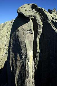 |
The range is made up from granite, which forms wonderful vertical faces in the area around Los Galayos and Puerto del Pico in the south as well as the high summits around Circo de Gredos. Therefore you’ll find best climbing options in these areas. Consequently the most frequented refuges have been built here, Refugio Victory underneath the walls of Los Galayos and Refugio Elola near Laguna Grande. The Torozo climbing area is very close to Puerto del Pico and thus can be reached from the car in about 15 minutes.
 |  |  |
Most summits of the range can be reached without much difficulty, especially if you start from the north. Access distances, however, can be long, negotiating long gorge-like valleys and starting the ascent from the cirques underneath the mountains. In most of these cirques you can find glacier carved lakes, among the most popular tourist attractions. The most famous ones are Circo de Gredos and Circo de Cinco Lagunas, which both are overshhadowed by the towering faces of the highest mountains of the range. With a bit of luck you will meet the Gredos Ibex (Capra pyrenaica victoriae) and with even more luck the Gredos Fire Salamander (Salamandra salamandra allmanzoris) there. Both were at the brink of extinction (the salamander still is) but the ibex popupaltion has rebounded after the first natural preserve was created near Laguna Grande in 1905. Today there are roughly 10000 specimen around, who all seem to know that they are protected. You’ll sometimes veritably stumble across on of the large bulls.
 |  |  |
To the north of Sierra de Gredos, separated by Rio Tormes and Rio Alberche there are three smaller and less important mountain ranges: Sierra de la Paramera, Sierra La Serrota and Sierra de Villafranca. Generally these ranges are not considered part of Sierra de Gredos but due to their close proximity their summits will be listed here. At least as long as there won’t be any separate pages for them on SP.
2 - Sierra de Gredos on SP

3 - The Summits
3.1 - Macizo Oriental
 Torozo in front of Macizo Oriental
The eastern part of Sierra de Gredos is far less impressive than its central and western brethren. Most of the summits are round-topped affairs, covered in Spanish Broom, which quite often buts a stop to summit attempts. A fine exception is the westernmost part, colse to Puerto del Pico, where Riscos de Villarejo and Torozo offer excellent climbing options on wonderful granite.
- Cabeza de la Parra (1639m)
- Cerro de la Encrilla (1597m)
- Cerro de la Pedriza (1299m)
- Cuesta del Enebro (1319m)
- Alto del Mirlo (1767m)
- La Pizarra (1759m)
- Canto del Berueco (1811m)
- Cerro de la Escusa (1960m)
![]()
- La Errencilla (1964m)
- Pico de Lanchamala (1994m)
- La Rubiera (2003m)
- Cerro de Chamuzo (1568m)
- Risco del Cuervo (1463m)
- La Serradilla (1989m)
- Mojon Cimero (1887m)
- Risco del Remolino (1827m)
- La Gamonosa (1924m)
- Alcaraban (1753m)
- Castillejo (1997m)
- Cabeza Santa (2068m)
![]()
- Cabezo de Mijares (2187m)
![]()
- Cabezo de Gavilanes (2191m)
![]()
- Risco de Miravalles (2008m)
![]()
- Cerro de la Cabrilla (1739m)
- El Zaburdón (1552m)
- Cabeza Aguda (1842m)
- Coberteras (1570m)
- El Frontal (1733m)
- Los Morenos (1878m)
- Piedra Caballera (2005m)
- Riscos de Villarejo (1878m)
![]()
- El Torozo (2026m)
![]()


3.2 - Macizo Central
Macizo Central is the largest and certainly most important part of Sierra de Gredos. For the sake of a better overview I divise it into three parts:
- Mira / Galayos Group
- Circo de Gredos
- Sierra Llana, Sierra de Tormantos
3.2.1 - Mira / Galayos Group
 Mojon de las Tres Cruces, Penon de Mediodia, La Mira, Los Galayos
This section of Macizo Central stretches between Puerto del Pico in the east and Puerto de Candeleda in the west. With La Mira it contains one of the most popular hiking summits of the whole range and with Los Galayos it offers a host of perfect climbing crags, made up from the best of granite. Los Galayos consist of a multitude of spires out of which only a handful are mentioned in the listing below. For a full listing visit the Los Galayos Area Page.
- Alto de Raigoso (1509m)
- La Casa (1848m)
- Risco del Duque (1847m)
![]()
- La Fria (1982m)
- Risco de las Morillas (1998m)
![]()
- Cerro Navarrenas (15388m)
- Cerro de las Campanas (1552m)
- Canto Cochino (1900m)
![]()
- Risco de la Cabrilla (1992m)
![]()
- Cerro Borreguero (1868m)
- Morron de las Tres Cruces (2164m)
![]()
- Peñon del Mediodia (2224m)
![]()
- El Mojinete (2104m)
- Risco Perico (2106m)
- La Tarayuela (2128m)
- Los Galayos (2216m)
![]()
- Peña Gallina
- Aguja Maravillosa
- Gran Galayo
- Punta Don Servando
- El Torréon
- Aguja Negra
- Las Berroqueras
- La Mira (2341m)
![]()
- Risco Enebro (1929m)
- Peñas de Chocarrón (2204m)
![]()
- Humbria La Galguera (2184m)
- Puntilla de la Galguera (2128m)
- El Raso (2174m)
- Cabezo de Cervunal (2094m)
![]()
- Corral de Venero (1978m)
- Tejo Las Mulas (1757m)
- Cabrional (1749m)
- Risco de los Cotrilles (2088m)
- Las Molderas (2241m)
![]()
- La Lanchosa (2158m)
![]()
- Piedras del Beso (2042m)
- Risco Pelucas (2199m)
![]()
- Los Campanarios (2106m, 2144m, 2153m, 2144m, 2165m, 2126m)
![]()
- Casquera del Jocino (1918m)
- Alto de Pajonal (2089m)


3.2.2 - Circo de Gredos
  |
Easily the most important part of Sierra de Gredos this subrange of Macizo Central contains the highest mountains of the range which are located around Circo de Gredos and Circo de Cinco Lagunas. Made up from granite like the remainder of the range there are wonderful climbing and mountaineering possibilities. Modt popular destinations are Almanzor, La Galana and Ameal del Pablo, which are separated from each other and othe summits by rugged ridges (Riscos).
- Risco Joracao (2099m)
- Los Morriones (1943m)
- Risco del Fraile (2247m)
![]()
- Cerro de la Cagarruta (2299m)
![]()
- Cuerda del Refugio (2129m)
![]()
- El Artiñuelo (2084m)
![]()
- Cabezo de la Solana (2096m)
![]()
- Canchon de las Chorreras (1938m)
- Peña Rayo (2032m)
- Cuento Alto (2272m)
![]()
- Morezón Bajero (2269m)
- Altos de Morezón (2364m)
![]()
- Morezón (2393m)
![]()
- Risco de la Hoyuelas (2318m)
![]()
- El Enano (2315m)
![]()
- La Campana (2259m)
- La Ventana (2316m)
- Los Cerraillos (2364m)
![]()
- Los Tres Hermanitos (2354m, 2340m, 2281m)
![]()
- El Perro que Fuma (2342m)
![]()
- El Casquerazo (2437m)
![]()
- Risco del Francés (2337m)
- El Duraznero (2179m)
- Alto de la Albarea (1917m)
- Alto del Pozo (1791m)
- Cuchillar de las Navajas (2508m)
![]()
- Punte del Cuchillar (2445m, 2437m, 2492m, 2475m)
- El Sagrao (2508m)
- Esbirladero (2045m)
- Sabinal (2069m)
- Almanzor (2592m)
![]()
- Cuerno del Almanzor (2538m)
- Cuchillar de los Ballesteros (2542m)
![]()
- Risco Portilla del Crampón (2562m)
![]()
- Risco de los Cachorros (2202m)
- Risco Redondo (2009m)
- Peña Chilla (2009m)
![]()
- Mogorro del Barril (1677m)
- Ameal de Pablo (2489m)
![]()
- Risco Moreno (2478m)
![]()
- Cuchillar del Cerro los Huertos (2459m)
- Cerro de los Huertos (2459m)
![]()
- Risco Negro (2295m)
- La Galana (2564m)
![]()
- Canchal de la Galana (2479m)
- Cabeza Nevada (2427m)
![]()
- El Novillero (2196m)
- Riscos del Gutre (2545m)
![]()
- Risco de Cinco Lagunas (2479m)
![]()
- Los Castillejos (2264m)
- Los Guindos (2025m)
![]()
- Peña Caballera (1696m)
- Caramito (1917m)
- Cabeza de Horcajo (1928m)
- Horcajo (1644m)
- Picurucho (2197m)
![]()
- Plaza de Toros (2313m)
- El Asperon (2337m)
- Risco del Fraile (2272m)
![]()
- El Calvitero (2158m)
- Cervunal (1882m)
- Riscos de los Parajjitos (1866m)
- Berrocco Grande (1727m)
- Risco de las Hoces (2166m)
![]()
- Cerro Pajares (1864m)
![]()
- Risco del Rayo (1556m)
- El Butraco (2218m)


3.2.3 - Sierra Llana, Sierra de Tormantos
The wetsern part of Macizo Central is less well known than its eastern counterparts. Access routes are long and even from the northern sides elevation gains can be huge. Moreover, there are only a few shepherding huts which might be used as shelters. The area is popular with hikers as there are quite a number of long, beautiful valleys which all end in a lake-filled cirque. But even here access routes are long. Most prominent mountain in this part of Sierra de Gredos is La Covacha the ascent of which can be fitted into a long loop hike (and scramble).
- Alto del Peso (2179m)
- Alto de la Batalla (2252m)
- Los Campanarios (2260m)
- Alto de las Beccedillas (2220m)
- Risco de la Mula (2109m)
- Mojon Altillo (2127m)
- El Tormal (2103m)
- Pastor de Mena (2045m)
- El Mostazo (1814m)
- Risco Negro (1669m)
- Calvitero (2254m)
- Casquero de Peones (2271m)
- Alto de Guija Blanca (2231m)
- Peludillo (2250m)
- El Tendero (1954m)
- Peña de Cantaelgallo (1560m)
- Lucia (2162m)
- Cabeza Pelada (2270m)
- El Belesar (2110m)
- El Cancho (2274m)
![]()
- Cerro de las Agujas (2099m)
- Risco de la Manzanilla
- Canchal de la Paloma
- Canchal de la Mentira
- Risco de la Ventana
- La Covacha (2399m)
![]()
- El Juraco (2283m)
![]()
- Alto del Corral del Diablo (2366m)
![]()
- Pelado Bernado (2214m)
- El Pelado (2219m)
![]()
- El Cebollar (1841m)
- Pico del Mosquito (2249m)
![]()
- La Azagaya (2367m)
![]()
- Alto de la Solanilla (2283m)
![]()
- Alto de Castilfrio (2308m)
![]()
- Mojon Alto (2164m)
![]()
- Risco del Aguila (1902m)
![]()
- Canchal de la Angostura (1974m)
- Peña Negra (1821m)
- El Estecillo (2250m)
- Canchal de Moreno (2045m)
- Alto de la Butrera (2281m)
- Corte de Cotriverde (2133m)
- Cerro de Acarradero (1822m)
- Las Enchinillas (1599m)
- Los Castillos (1615m)
- Risco del Cabeccero (1772m)
- La Panera (1814m)
- Alto del Pozo (1725m)
- Peñon de Torrique (1711m)


3.3 - Macizo Occidental, Sierra de Bejar
With Macizo Occidental, also Sierra de Bejar Sierra de Gredos has a small but important cumulation point in the west. Its highest and most popular summits are Canchal de la Ceja and Torreon del Calvitero, which can be climbed together in a day from the trailhead at Plataforma del Travieso. Even more scenic is the hike along the Lagunas del Trampal, which joins the crest of the subrange between Canchal de la Ceja and Cuerda del Calvitero.
- Alberca (1493m)
- Campazo (1557m)
- Fuentesauco (1683m)
- Peña Garci-Sanchez (1956m)
- Peña Negra (2217m)
- Risco de Aguila (2059m)
- Canchal Negro (2269m)
![]()
- Peña del Hombre (1984m)
- La Serenita (1752m)
- Cuerda del Calvitero (2397m)
![]()
- Canchal de la Ceja (2428m)
![]()
- Torreón del Calvitero (2400m)
![]()
- Cumbre de Talamanca (2312m)
![]()
- Canchal del Turmal (2338m)
![]()
- Risco la Campana (2093m)
![]()
- Los Dos Hermanitos (2322m)
![]()
- Pie Sequillo (1922m)
- El Posturillo
- Cerro del Moro (1845m)
- Canchal de la Gallina


3.4 - Sierra de la Paramera
Sierra de la Paramera is a lower range to the north of Macizo Oriental and separated from the higher range by Rio Alberche. Its highest mountain is Pico Zapatero (2160m). It is the home range of Avila and the ridge traverse across Pico Zapatero is the most famous undertaking in this subrange.
- Cabeza Piornesa (1526m)
- Lanchal de la Cancha (1587m)
- Navaltravieso (1456m)
- El Barrizal (1525m)
- Los Carracales (1829m)
- Peña Cabrera (1974m)
- Peña Negrilla (1770m)
- Cuchillo (2098m)
- Risco del Sol (2104m)
- Pico Zapatero (2160m)
![]()
- La Joya (2133m)
- Valdemerina (1739m)
- Cabeza Redonda (1957m)
- Peña del Cuervo (1811m)
- Las Zorreras (1856m)
- La Pedriza (1834m)
- Cerro de los Arrecios (1913m)
- Alto del Puerto (1907m)
- Canto Bolero (1653m)
- La Hoyuela (1612m)
- Cerro Pelado (1551m)
- La Mesa (1440m)
- Frontal (1612m)
- Pradejones (1686m)
- Tras La Cabeza (1507m)
- Navasolana (1708m)
- El Cerro (1598m)
- Lanchal (1542m)
- Gallinero (1616m)
- Calamocho (1506m)

3.5 - Sierra La Serrota
A small subrange, almost made up from one single summit, Sierra la Serrota is located between Sierra de Villafranca and Sierra de la Palamera to the north of Sierra de Gredos proper.
- Berrueco Negro (1638m)
- Cerro de Navalacierva (1738m)
- Pico Moro (2010m)
- Canto Moreno (1688m)
- Cabeza del Valle (1680m)
- Cerro del Santo (2270m)
- La Serrota (2294m)
![]()
- Pajarote (1933m)
- PeñaPajarita (2135m)
- Cerror de Valdehierro (1986m)
- Mesa de Valdehierro (1689m)
- Cerro Pelado (1914m)
- Cerro Pinar (1644m)
- Los Cuartos (1604m)
- Peña Levante (1682m)
- El Cueto (1924m)
- Piedra Lobera (1944m)
- Guijuelos (1924m)
- Las Mesillas (1796m)

3.6 - Sierra de Villafranca
Sierra de Villafranca is the westernmost of the three lower ranges north of Sierra de Gredos. Both ranges are separated by the valley of Rio Tormes.
- Peña Cachá (1655m)
- La Cumbre (1683m)
- Romarcos (1724m)
- Piedra Aguda (1819m)
- NavarquitaAliagas Blancas (1796m)
- Cerro de las Umbriazos (1749m)
- Cerro Pelado (1749m)
- Robles Gordos (1708m)
- Cerrolonguillo (1925m)
- Mojón de Guillén (2024m)
- Los Moros (2065m)
- Cerro Santo (1743m)
- Cerro de los Ruillos (1752m)
- Peña Negra (1918m)
- Mojón Alto (1932m)
- Peña Hendina (1878m)
- Cerro de la Cabeza (1801m)
- Mesa Grande (1889m)
- Mingo Peña (1879m)
- Tarayuela (1967m)
- El Molar (1672m)
- Castrejón (1651m)
- Cabeza Pelada (1679m)
4 - Getting There
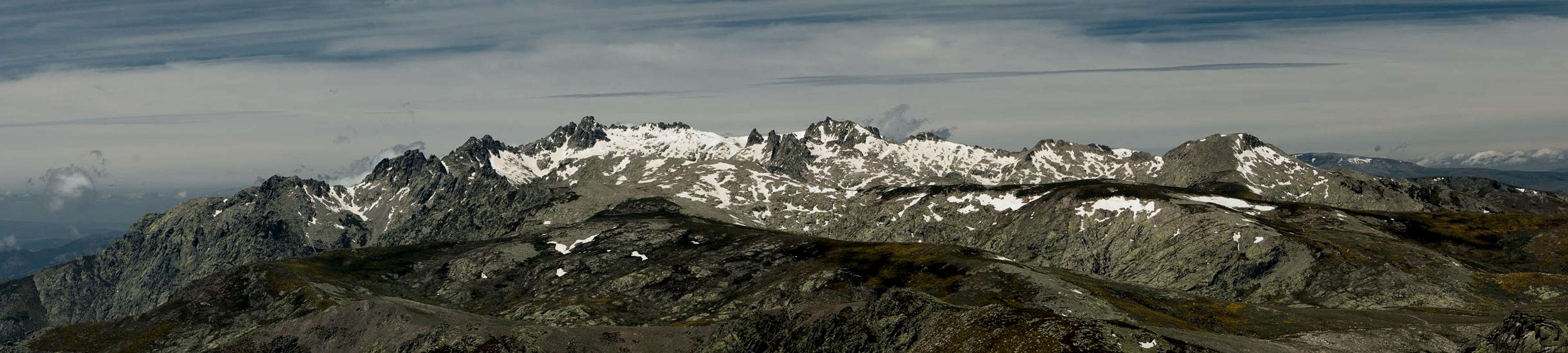
 Central Sierra de Gredos from La Mira
- Northern Access
- From Madrid take motorway A-6 / AP-6 to Villacastín
- Switch to Motorway AP-51 to its end at Ávila
- Take N-403 south for the easternmost part of Macizo Oriental
- Take N-502 south-east to Puerto del Pico between Macizo Oriental and Macizo Central
- Take N-110 west-south-west for all other subranges
- Take N-403 south for the easternmost part of Macizo Oriental
- From Madrid take motorway A-6 / AP-6 to Villacastín
- Southern Access
- From Madrid take A-5 / E-90 south-west
- From Maqueda take N-403 south for the easternmost part of Macizo Oriental
- From Talavera de la Reina take N-502 south-east to Puerto del Pico between Macizo Oriental and Macizo Central
- Close to the range on its southern side a narrow road leads all the way from San Martín de Valdeiglesias in the east to Jarandilla de la Vera in the west. It bears different notations (east to west):
- M-601 east of Sodrillo de la Adrada
- CL-501between Sodrillo de la Adrada and Madrigal de la Vera
- EX-203 west of Madrigal de la Vera
- M-601 east of Sodrillo de la Adrada
5 - Accommodation
 Laguna Grande Mirror
Rather than direct you at specific websites I would encourage you to do a Google search. Most of the websites are commercial and some of them require additional fees.
Google search for accommodation near Sierra de Gredos
6 - Red Tape
 Risco de Miravalles
Today an area of 86.00 ha is protected by the Parque Regional de la Sierra de Gredos, which dates back to 1905, when a hunting area was established for King Alfonso XIII around Laguna Grande and Cinco Lagunas. There are two smaller areas designated as Reserva Natural, Valle de Iruelas and Garganta de los Infiernos. Finally, the Sierras de Paramera y Serrota, a part of Sierra de Bejar and Pinar de Hoyocasero are protected as Espacio Natural.
7 - Weather Conditions
8 - Maps & Books
8.1 - Maps
- Sierra de Gredos
Mapa Y Guía Excursionista
Editorial Alpina
1:25000
ISBN: 978-8480903097
- Parque Regional de la Sierra de Gredos
Adrados Ediciones
1 :135000 / 1 :25000
ISBN : 978-8492236367
8.2 - Books
- Sierra de Gredos: Circo de Gredos – Valle del Tiétar – Valle del Jerte
B. Plikat
Rother Verlag
ISBN: 978-3-7633-4716-2 (Spanish)
ISBN: 978-3763343812 (German)
- Sierra de Gredos : guía de escalada
R. Lora
Ediciones Desnivel
ISBN: 978-8498292848