Intro
Waterman Mtn, CA (8038')
San Gorgonio Mtn, CA (11499')- Lower 48 prominence rank-7
San Bernadino county highpoint
December 16-17, 2007
Slideshow
I was out in CA for the third straight year for a short work trip and decided to take advantage of it again by hitting another county highpoint. San Gorgonio is high on many highpointer lists as it not only is the highest mountain in the L.A. area, but also in all of southern California. It checks in at #7 on the lower 48 prominence list, bested only by Rainier, Whitney, Shasta, Elbert, Baker, and San Jacinto. My dad's family lived in Redlands & San Bernadino at the base of this monarch, so this peak had some family ties for me. My friend
Bruno Lucidarme from summitpost hiked mighty Baldy with me last Dec and had hoped to join me for San Gorgonio, but work demands kept him from joining me on a Monday. We decided to do a warmup hike in the San Gabriels on Sunday after I arrived, so ranked 8er Waterman was on the agenda as it is a short hike with good views.
Warmup on Waterman
Warmup on Waterman
6 miles RT, 1500' gain
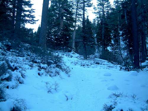
Bruno and his fiancee Chrissy picked me up at a pullout on the Angeles Crest Hwy and we headed up into the San Gabriels for Waterman. We followed the windy paved road about 34 miles north if I-210 to just past the Mt Waterman ski area to the trailhead at 6740'. Yes, there is a ski area on an 8er! We made fun of the signs warning of chains being necessary on the road as there were just a few icy patches.
This is a nice hike if you're pressed for time and only have a few hours to burn in the L.A. area. This peak is on the Sierra Club 100 Peak section list and is ranked. We headed out at 12:51 as the temps were in the upper 40's, a far cry from the mid-teens I was hiking in just the day before in CO.
From near the Buckhorn Guard Station, we hit a fire road that took us to the trail which was well packed from the weekend. Apparently this is a popular hike as we came across a fair amount of folks heading up. Chrissy set a nice pace as the trail climbed gently up to the east ridge of Waterman. The views opened up to the south over to neighboring Twin Peaks and beyond. From here, the trail heads west to the summit, skirting around Pt 7910 to the north. The trail was pretty much hard packed snow most of the way. You never see consolidated snow like this in CO in Dec!
I scrambled up to the benchmark and noticed some rock outcroppings to the east that looked higher, but according to the Sierra Club the benchmark is the highpoint. Bruno led us over to some cool rock outcroppings to the south that afforded some awesome views of Baldy and the ocean glimmering in the distance.
![Mt Wilson and ocean from Waterman]() The Pacific with Mt Wilson in the foreground.
The Pacific with Mt Wilson in the foreground.
After a nice break, we headed back up to the summit where I checked out the other candidate highpoint to the east, which was a cool class 3 scramble. The trail was a bit slick on the way down, but not bad at all. We made it back down around 4:15. It was a great hike to get the blood pumping for a long day tomorrow!
A Long Way to the Top on San Gorgonio
~16 miles RT, 5500' gain
Via Vivian Creek trail (6080')
Bruno and I had slim hopes of climbing 14er White Mtn Peak in the desert, and a big storm about a week before our hike closed the road for the season. San Gorgonio is a tall task in winter conditions, and I knew I would have to get lucky with the timing of the storms to pull this off reasonably as a dayhike. My good luck this year with the weather continued, and a week of dry weather melted quite a bit of the snow from the previous storm. Maybe the trail would be packed down from the weekend!
I left my hotel in Redlands early and found the trailhead in the dark without any problems. After fumbling around with getting my snowshoes on my pack, I set out at 5:47am with a temp of 32 degrees, warm enough to wear my summer Merrell Chameleons. I would have the whole mountain to myself, which is hard to believe considering it's so close to L.A! The route initially parallels Mill Creek from Big Falls campground on a road before crossing the wide but dry creek. I didn't have any trouble finding the trail on the other side as it was well signed.
The Vivian Creek trail wastes no time in getting your lungs burning, as it is initially pretty steep. I tried to control my pace up the switchbacks as I knew it would be a long day. Since this was on a south facing slope, the trail was dry so far. It then mellowed out as it entered the Vivian Creek drainage, and from here it was mostly hard packed snow the rest of the way with a few dry patches.
![Vivian Creek drainage]() Heading up the nicely packed Vivian Creek drainage.
Heading up the nicely packed Vivian Creek drainage.<
It looked like the trail had seen quite a bit of traffic over the weekend, so my prospects of summitting were looking good. After about 3 miles, I reached Halfway Camp, which isn't really halfway! I noticed the trail has likely been re-routed in recent years as it was varying quite a bit from the trail marked on my GPS map. Maybe this used to be halfway! From here, the trail switchbacks up west and south facing slopes to High Creek camp at 9200'. There were nice views of the lower peaks across the valley on this stretch.
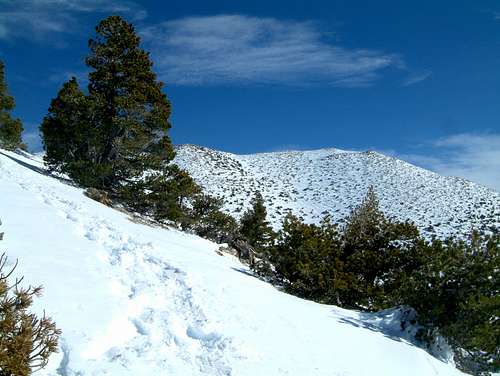
Beyond High Creek camp, the butt kicking commenced. Whoever initially broke trail wasn't able to follow the trail, so it was pretty much a steep 800' beeline to the south ridge. Luckily the snow was well consolidated for me and I was able to get by w/o snowshoes until about 2/3 of the way up when the slip-n-slide was getting annoying. My MSR Denali's did the trick and I left them on all the way to the summit. Once on the south ridge, things got easier and I got my first view of the summit, looking a long ways away!
![San Gorgonio from south ridge]() First view of San Gorgonio along the south ridge.
First view of San Gorgonio along the south ridge.
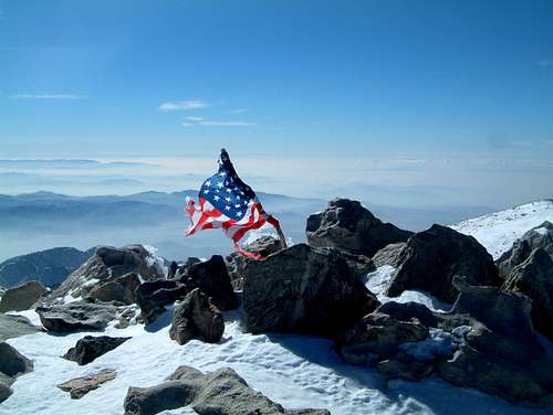
The trail stays on or close to the ridge before skirting below Jepsen Peak and it was easy to follow the rest of the way. I was amazed at how bulletproof the snow was as a thick coat of ice laced it in many spots. It would be a struggle without crampons or snowshoes. The rime ice was beautiful. About 200' below the summit, the winds kicked in but they were to my back. I crested the ridge and the summit was now in site! The winds pushed me up the trail and I topped out at 11:08, greeted by Old Glory getting blasted by the wind.
![Old Glory on San Gorgonio summit]() Old Glory on the summit of San G.
Old Glory on the summit of San G.
I took shelter below some big boulders on the north side as the summit was inhospitable for a break, 36 degrees with probably 30-35mph sustained winds. 36 feels much colder in CA with the humidity! After a much needed 30 minute break, I headed down.
It was now time to get mentally prepared for another 8 miles. San G has a couple false summits and I visited Pt 11490 to the n.w. just to be safe. The views on the way down were surreal as the ice glistened against the slopes and clouds below.
![Ice Capades on San Gorgonio]() Ice capades on San Gorgonio.
Ice capades on San Gorgonio.
Once I was a couple hundred feet below the summit, I was out of the full brunt of the wind for good. My snowshoes did great on the ice. Once back down to 10K' on the ridge, I bombed down the bobsled run back to High Camp. I tried glissading a couple times, but there were too many trees in the area!
The hike back out wasn't as bad as expected as the icy patches melted a bit and I was able to avoid any falls. I crammed enough food down on the summit to keep my energy up and made good time, although the section down Vivian creek drainage seemed to take forever. I was back at the car at 3:28, happy to steal a December hike on mighty San Gorgonio. About 2 hours after I finished, a storm blew in, so San G has probably got a lot of new powder on it now!


Comments
Post a Comment