
-
 9040 Hits
-
 84.82% Score
-
 19 Votes
|
|
Mountain/Rock |
|---|---|
|
|
41.53380°N / 122.27925°W |
|
|
Siskiyou |
|
|
Spring, Summer, Fall, Winter |
|
|
4163 ft / 1269 m |
|
|
Overview
 The Haystack
 The Haystack, with the Trinity Divide in the distance
The Haystack is an all but forgotten volcanic dome in Northern California’s Shasta Valley. Lying in the shadow of mighty Mount Shasta, the valley is an area often overlooked when it comes to outdoor recreation. While the valley has numerous interesting small mountains, most people simply pass on through, intent on getting to the high country to the south. Those looking with interest at the valley’s small mountains are forgiven for assuming they are on private land due to the abundance of cattle ranches visible from the highways. While this is true in most of the Shasta Valley, there area couple of significant exceptions to the rule. The Haystack, found on the north side of Highway 97, is one of the best of these exceptions. Separated from the rest of the Shasta Valley’s small peaks, the Haystack, along with neighboring Yellow Butte, offer great off-season hiking options with astounding views in all directions. When the high country above the Shasta Valley is still blanketed in snow, a trip to the top of the Haystack will quench the thirst for alpine scenery.
 Peaks lining the the eastern edge of the arid Shasta Valley. Seen from the Haystack
The Shasta Valley lies in Mount Shasta’s rainshadow, an area of significantly reduced rainfall caused by the proximity to a major mountain feature. As storm systems pass over Mount Shasta, the moisture is pulled out of the storm. Once past the mountain it does not have much moisture left to contribute significant precipitation to the area. Thus, the Shasta Valley is a high desert. The Valley is marked by Mount Shasta at its southern end. The Klamath Mountains, particularly the Scarface Mountains, mark the western boundary while the Cascade crest composes the eastern wall. The Klamath River, Black Mountain and Paradise Craggy form the northern perimeter of the Valley. The Shasta River drains the whole area. While the valley is generally flat, there are a significant number of hills and small mountains in the center of the valley. These were formed by an ancient rockslide off of Mount Shasta. The Haystack, and its close neighbor, Yellow Butte, are outliers, being much further to the east the rest of the cluster of hills. Moreover, they are created by volcanic activity. The surrounding lava flows and the cinder quarry are evidence that these small mountains are the result of volcanic activity rather than a rockslide.
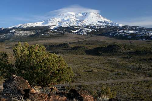 Mount Shasta from the Haystack
Located just north of Mount Shasta, the Haystack is in a transition zone within the mountain’s rainshadow. A short distance to the north is the alpine environment of Mount Shasta. As the lower flanks of the mighty volcano slope down to the north the forest gives way to open brush fields punctuated by occasional ponderosa pines. Highway 97 runs along the northern edge of this area. Just beyond the highway the brush is taken over by dense juniper forests. This area is known as the Juniper Flats. The Haystack is located in the heart of this transition zone. The butte is a distinctively shaped frustum, a neatly truncated cone. It rises 600 feet above the Juniper Flats on three of its sides. On the northern side, the Haystack has only 300 feet of relief, since it is connected to the higher plain sloping off of Mount Shasta. Like most of the peaks in the Shasta Valley, the Haystack is composed of volcanic rock. This is particularly evident on the northern and eastern sides of the mountain, where large bands of the rock are exposed, forming attractive cliffs.
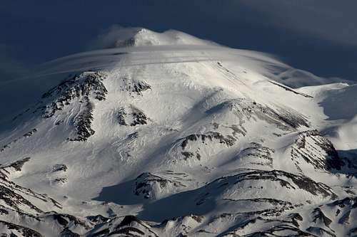 Lenticular clouds forming on Mount Shasta, as seen from the Haystack
The summit of the Haystack is a broad plateau populated by large (for this area at least) juniper trees. A trail follows the perimeter of the summit plateau and offers excellent 360-degree views. Needless to say, Mount Shasta is the highlight and dominates the vista from nearly any position. To the west, Mount Eddy, China Mountain and the Trinity Divide are an immense presence. The Shasta Valley and the Siskiyou Mountains stretch out into Oregon north of the Haystack. To the east, Herd Peak, the fantastic cliffs of Sheep Rock, Yellow Butte, Whaleback and Ash Creek Butte are all visible.
Route
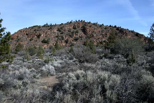 The northern wall of the Haystack, seen from the trailhead
The route to the summit of the Haystack is an old, easily followed dirt road. Generally two-track, the road sees little use and in some places would take a high clearance vehicle and some serious skill to negotiate. It is much better suited to foot travel. From the small pullout off of Highway 97, pass through the gate and follow the road for 1 mile to the summit. On the gate, there is a warning regarding the presence of bees. White boxes typical of apiculture are clearly visible beyond the gate but they have not been used in some time. It is possible that activity could resume in the future.
Beyond the gate, the road heads west, before turning sharply to the east. As it does, it passes through a small canyon, under the rugged cliffs of the north side of the Haystack. Soon the road reaches the precipice of a cliff, high above the Juniper Flats. The road turns to the north, traversing the middle flanks of the butte. After climbing moderately for 0.25 miles, the road switchback, turning to the south and making the final push to the summit. There views to the east are excellent. Once on the summit, the road gets fainter as it makes a 0.6 mile loop around the summit plateau with excellent views in all directions.
Maps
 The Haystack and Yellow Butte area
 Route to the summit of the Haystack
Getting There
 The view north, into the Shasta Valley
From downtown Weed, drive east on Highway 97 for 10.5 miles. A small dirt road blocked by a green gate will be on the left. Park next to the gate. 9.5 miles from Weed, Highway 97 crosses over usually dry Whitney Creek. Visible ahead is the Haystack with Yellow Butte beyond. The dirt road is 0.5 miles beyond Whitney Creek. Be sure to close the gate at the beginning and end of the hike to the Haystack.
Camping
 Sunset over the Shasta Valley, seen from the Haystack
The closest campground is located at Lake Shastina. To get there from Yellow Butte, head west on Highway 97 for 6.5 miles and turn right on Big Springs Road. After 1.7 miles turn left on Jackson Ranch Road. Drive 1.0 miles and turn right on Dwinell. Follow the road to the campground on the lakeshore.
Dispersed camping is allowed throughout the area surrounding Yellow Butte, particularly to the south of Highway 97.
Red Tape
 Sheep Rock, in the Klamath National Forest...sort of
Haystack's proximity to Mount Shasta would lead one to assume it is in the Shasta-Trinity National Forest, it is in fact on the Klamath National Forest, which manages the Forest Service lands north of Highway 97.
Klamath National Forest
1312 Fairlane Road
Yreka, CA 96097-9549
(530) 842-6131
Goosenest Ranger District
37805 Highway 97
Macdoel, CA 96058
(530) 398-4391