
|
|
Canyon |
|---|---|
|
|
38.67420°N / 110.1526°W |
|
|
Hiking, Trad Climbing, Scrambling, Canyoneering |
|
|
Spring, Summer, Fall, Winter |
|
|
Overview
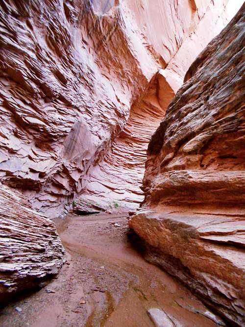
Three Canyon is south of Green River Utah and is a side canyon of Labyrinth Canyon. It is in the greater Robbers Roost area as well, but quite a bit north of the main part of the Roost.Three Canyon is usually ignored by hikers and canyoneers. The entry and exit routes are hard enough to keep out hikers, and since the canyon has few technical obstacles and is mostly a hike, and since there isn’t a real slot, not many technical canyoneers do the canyon either. What the canyon is however, is probably the most beautiful of all the side canyons draining into Labyrinth Canyon of the Green River. The high walls streaked with desert varnish, the oasis in the desert, the small cascades, deep narrows, and crystal clear running water make the trip very pretty.
Three Canyon did get some attention in the late 1990’s and early 2000’s when some of our friends put the canyon in a guidebook and on a website, but as more canyons became known, Three Canyon more or less has dropped off the radar again. Other than near the river, I have seldom seen any footprints.
 Three Canyon
Getting There
Sneak Route TrailheadFrom the main drag in Green River Utah, located Broadway near Rays Tavern and drive south along Broadway before turning left (just before the railroad tracks and Amtrack Station) onto Green River Avenue. Follow Green River Avenue and turn right on Airport Road. (Besides Broadway, you can also turn south on S Cherry Street or S Long Street [at the Chow Hound] to reach Green River Avenue and Airport Road).
Follow Airport Road for 2.3 miles to a signed turnoff and the BLM/NPS bulletin board on the left for Horseshoe Canyon and the San Rafael Desert.
Turn south on this gravel road (usually in good condition for all vehicles, but after a big rainstorm, it can be impassible) and follow it for 19.2 miles to the bridge over the San Rafael River. Continue on the main road south for 3.5 miles to a minor road on the left that has a sign "Designated Off-Road Route". Turn left and follow the faint track up a steep hill (passenger cars may not make it, but I made it OK in my Subaru). Follow the road 0.2 miles or so until you can look south into the Three and Sneak Canyon area.
 Looking down Sneak Canyon from part of the Sneak Route, which isn't far from the trailhead. The steep part is where the route drops over the rim visible.
Upper Three Canyon Trailhead
From the minor intersection mentioned above, instead of following the "Designated Off-Road Route", continue south along the main road for about 3.7 miles to an intersection. There is good parking near the intersection.
Routes Overview
Three Canyon via Upper ThreeThis route accesses the canyon from the head of the canyon. There are some shallow narrows before reaching a 100 foot rappel, the only technical obstacle in the canyon. Below that, there are only minor obstacles including one short and non-exposed class 3 ten foot drop and a short section very minor bushwhacking.
 Looking down the 100' foot rappel in Three Canyon.
Sneak Route
The Sneak Route is my favorite entrance and exit to Lower Three Canyon. The route is rated 5.6 and has a few antique bolts along it. If you are using this as an exit route and you don't want to free solo the 5.6 climb, you can fix a rope, handline, or aider at the crux of the route before you climb up it. This is a very fun route, but has some exposure.
 Part of the 5.6 section of the Sneak Route. I left the aider because I didn't want to freesolo it alone. Notice the chipped Moki step.
 Map showing the Upper Three Canyon Route and Sneak Route. Click for full size.
Junes Bottom
This route won't be discussed in detail here, but you can access Junes Bottom via a very old and washed out road off the canyon rim. An old, faded, and very rugged cattle trail accesses the mouth of Three Canyon by traversing the talus above the Green River. This is the route I used to use to access Three Canyon, but it isn't as fun as the other routes.
Trin Alcove Horse Trail
This route also won't be described in much detail here, but from the end of the "Designated Off-Road Route" beyond the Sneak Route Trailhead, an old horse trail drops off a shallow rim. It has access to the Green River. You can access the mouth of Three Canyon by traversing a small ledge above the river and to the mouth of Three Canyon. This is a good route, but if the route is wet or icy, beware of slipping and falling into the river!
Labyrinth Canyon/Green River
Three Canyon can be and often is accessed from the Green River through Labyrinth Canyon, which makes and excellent multi-day rafting or canoeing (better) trip.
Sneak Canyon
Sneak Canyon itself can be descended and is a nice slot canyon. The biggest rappel is just over 90 feet.
Baby Slot
The Baby Slot is the canyon that drains into Three Canyon east of Sneak Canyon. It can also be descended and is a good, but short slot canyon followed by an 154 foot rappel.
Route Page
Here is a route page describing the descent of Upper Three Canyon and exiting out the Sneak Route and Lower Three Canyon. In my opinion, this is the best route to see the canyon.
Upper Three to Sneak Route
Red Tape
This is Utah. Behave yourself. There is no Red Tape. In addition to no permits required, there is no private land for miles around in any direction either. There is no Red Tape; only red rocks.
 When to Climb
Three Canyon is a good destination year round.Summers are hot with temperatures exceeding 100F degrees (38C) on a regular basis, but Summer usually really isn't that bad because there is shade and water in much of the canyon, with a pool or too to cool off in.
Winter temperatures drop well below 0F (-18C), but winter is usually a good time to visit the canyon since snow cover is generally light.
The best times of the year for this adventure however, are March through May and then again in mid-September through mid-November. There is only minor flash flood potential in this canyon.
This is a land of weather extremes. Temperatures in the nearest town have ranged from -42F (-41C) to 113F (45C) at Green River. Sunny weather predominates and it only rains a few times a year, but when it does rain, it can really pour! Such storms are infrequent however.
 The little bit of May greenery highlights the red rocks.
Camping
There are fair to good scattered throughout this region. The nearest official campground is In Green River State Park, about 25 miles north of here.I'd highly recommend camping at the Chaffin Geyser since you will be assured of seeing an eruption of you camp there. The Chaffin Geyser is located off a side road not for north of the San Rafael River Bridge. The side road heads east and to the geyser.
 The Chaffin Geyser (cold water) is near the San Rafael River just north of Three Canyon. It was having a small eruption when I visited it.
Camping is possible in the canyon. The best campsites are near the Green River.
 A good water source is available in Three Canyon, which makes camping pleasant.
Canyon Conditions
It isn’t always easy checking on current conditions (which are usually not bad). The best bet might be to call the Maze District of Canyonlands if you want to check on road conditions of the Green River Road.Click Here For Weather Forecast
This is a land of temperature extremes, but of little rain or snow. Temperatures have ranged -42F (-41C) to 113F (45C) at Green River. Sunny weather predominates and it only rains a few times a year, but when it does rain, it can really pour!
Weather and climate data for the Green River is below. *National Weather Service Data 1893-2009.
| MONTH | AVE HIGH | AVE LOW | REC HIGH | REC LOW | AVE PRECIP (in) |
| JAN | 38 | 10 | 65 | -42 | 0.42 |
| FEB | 48 | 19 | 71 | -32 | 0.43 |
| MAR | 60 | 28 | 85 | 4 | 0.49 |
| APR | 71 | 36 | 95 | 9 | 0.51 |
| MAY | 81 | 45 | 102 | 23 | 0.64 |
| JUN | 92 | 52 | 110 | 30 | 0.33 |
| JUL | 98 | 60 | 113 | 40 | 0.54 |
| AUG | 95 | 58 | 110 | 37 | 0.81 |
| SEP | 86 | 47 | 102 | 25 | 0.70 |
| OCT | 72 | 35 | 92 | 10 | 0.79 |
| NOV | 55 | 22 | 79 | -6 | 0.44 |
| DEC | 41 | 13 | 65 | -23 | 0.36 |