
|
|
Mountain/Rock |
|---|---|
|
|
43.25189°N / 42.86563°E |
|
|
Download GPX » View Route on Map |
|
|
Mountaineering, Mixed, Scrambling |
|
|
Summer |
|
|
14632 ft / 4460 m |
|
|
Overview
The Tyutyu massif include five independent summits – East 4400m, Main 4460m, Central 4430m, 2d West 4420m and West 4350m. The name from local language means „barberry summit“. The most long exposed and truly alpine route are from the north side. They can be reached only on foot or by helicopter from Tyutyu-sy valley. The most rocky routes are easy reachable from the Adir-sy valley (south side). Not least because of the good rode and stationary alpine base. It's a some kind of simple hostel and camping ground it the same time. It takes only 4-5 hours to access the south face of Tyutyu from here.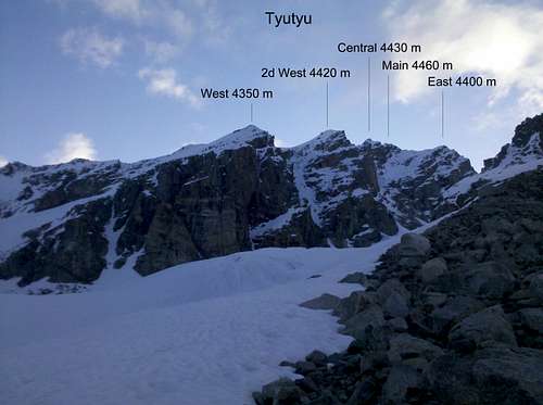
The massif of Tyutyu from South
Getting There
From airport Mineralnye Vody (www.mvairport.ru) by Bus via Naltchik (en.wikipedia.org/wiki/Nalchik) to Verkniy Baksan. From her you can order a transfer to alpine base Ullu-Tau or go on foot (ca. 2,5-3 h).It's possible to take a taxi from airport to Verkniy Baksan or even to alpine base Ullu-Tau.

Region of Adir-Sy valley
Routes
1. Travers from East to West PD2. Travers from West to East PD
3. Tyutyu 2d West, from South, Egor Dulnev TD
4. Tyutyu 2d West, from North, Mikhail Hergiany TD
5. Tyutyu East, from North, B. Garf TD
6. Tyutyu 2d West, West ridge, F
7. Tyutyu 2d West, South ridge, AD
8. Tyutyu Main, North ridge, I. Kahiany TD
9. Tyutyu West, South face, I. Htchkevitch TD
10. Tyutyu Central, West ridge, PD
11. Tyutyu 2d West, South face, Rigikov TD
12. Tyutyu 2d West, South-East face TD
Red Tape
On the Russian side it's forbidden climb on the summits and passes on the mane ridge (Russian-Georgian border). It' sounds stupid but unfortunately is true. But Tyutyu isn't on the border it self. So it's possible to climb those routes. In anyway your have to manage access permission for the border zone.When to Climb
The best time from middle of July till end of August.Camping
Stationary alpine base Ullu-Tau is a some kind of simple hostel and camping ground it the same time.www.ullutau.ru/camp/ullutau/?contacts