
-
 7627 Hits
-
 81.84% Score
-
 14 Votes
|
|
Mountain/Rock |
|---|---|
|
|
46.56783°N / 9.23195°E |
|
|
Hiking, Skiing |
|
|
Spring, Winter |
|
|
9610 ft / 2929 m |
|
|
Overview
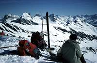
 Valserhorn - Tallihorn - Barenhorn from ESE
On the N side of the Splugen valley, just between Nufenen and Medels, a sequence of well jointed slopes give access to the main ridge hosting 3 summits : Valserhorn - Tallihorn - Barenhorn.
On these slopes 3 fine ski-mountaneering routes, not difficult at all, not too long and with a difference in elevation good enough to train and to amuse while descending.

The short time and distance from Milano, Como or Bellinzona make them a good goal for one-day shots, especially in January and February when the snow (due to the fact that this is the coldest part of the valley) is normally abundant and good just few meters out of the highway.
Later in the season the orientation (SE) can cause a very fast snow melt !
Getting There
From Milano to Como, Chiasso toll then highway to Chur (San Bernardino)Cross the San Bernardino tunnel and exit at the second "aussfart" : Nufenen.
Car parking is absolutely free of problems.
Valserhorn (2885m)
 |  | Cross the built up area along the ascending road and at its end go toward the wide ridge hosting some small huts. Once at the biggest one the slopes toward left pointing to the small saddle right of the summit. Along the short NE ridge to the summit |
time required ~ 4 hours
Tallihorn (2820m)
 |  | As the previous but once at the biggest hut cross toward right then again toward left to get, along a steep final slope, the saddle to the right. Along the short NE ridge to the summit |
time required ~ 3 hours
Barenhorn (2929m)
 |  | from the E border of the built up area cross toward East to get the wide rib in the skiline. Follow it till a wide saddle that allows to enter in a parallel valley on the right (Butznertal). Along the left side then, when the slopes get steeper, cross the high part toward right to get a saddle on the right of the summit and get it along the NE ridge. If the cornice on the ridge is big you better climb the last slopes to get the ridge closer to the summit (left of the saddle) |
time required ~ 4 hours
Descent
along the same routes.I heard about a fine descent along the Butznertal (from Barenhorn) but I haven't done it.