
-
 25941 Hits
-
 90.81% Score
-
 33 Votes
|
|
Area/Range |
|---|---|
|
|
46.41706°N / 8.69294°E |
|
|
Hiking, Mountaineering, Trad Climbing, Sport Climbing, Skiing |
|
|
Spring, Summer |
|
|
11656 ft / 3553 m |
|
|
Overview
between Simplon pass and Splugen passThe name come after the old people of "Leponzi" , an ancient Celtic people living in this area and whose found inscriptions are dated from about 300 BC.
this is a wide range oriented W-E that is the main watershed of Europe, on its northern side the Rhein river basin, on its southern side the Po river basin.
Mountains in this range are not as high as its W neighbours ((Pennine Alps where the ridge is often over the 4000m) nor as its E neighbour (Retiche Alps where the ridge is often over 3600m)
on the other side, this range is normally deep and the distances between N and S main valleys are normally big.
Wide variety of rocks .. starting with the fantastic granite near the St. Gotthard and ending with the crumbly rocks in its eastern part, somewhere, especially in the eastern part some dolomite or limestone banks come out in the main ridge ...
A great variety of climbing difficulties ... extreme climbing on granite, fine alpine climb on most of its summits, a large choice of fine hiking routes, the best range to start mountaneering without big risks.
These summits are sometimes busy, full of Lombardic and Ticinesi climbers or hikers that, starting from home, can climb almost all these summits without having to spend the night in refuge or elsewhere but home ...
... few come from abroad, unknowing what they lose :)
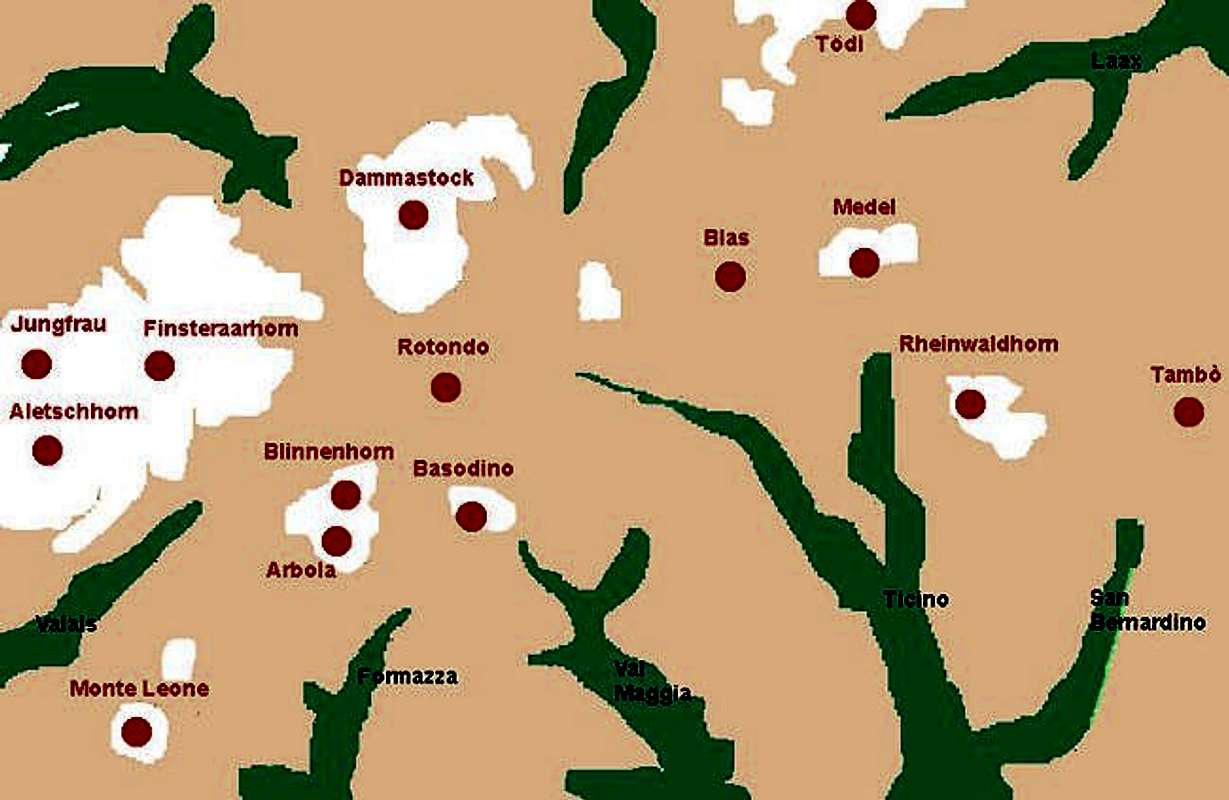
As for geographic and orographic structure we can define here these groups :
Leone group
Blinnenhorn (Corno Cieco) group
Basodino and Ticino
Rotondo group (San Gottardo)
Blas group
Medel group
Adula (Rheinwaldhorn) group
Tambò group
Getting There
from Italy (South)from Switzerland - south access - from West to East
Ticino valley - starting from Locarno
Ticino valley - starting from Bellinzona
from Switzerland - north access - from West to East
Leone group
after the Simplon pass the main ridge goes toward north with the important group of Monte Leone hosting some remarkable summits (from S to N) : Monte Leone - NE side | 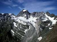 Monte Cervandone - E side |  Punta della Rossa |
Main valleys and accesses
from Switzerland (W side) : the Rhon valley
from Italy (E side) : valle del Toce
Blinnenhorn
Few km North of this group another fine one, the Blinnenhorn with its fine (few summits)the group ends, to the N with the Nufenenpass and to the East with the Passo di S.Giacomo that joins the Val Formazza (Piemonte-Italy) with the Val Bedretto (Canton Ticino-Switzerland)
 Sabbioni lake and the range from Nefelgiù to Sabbioni | 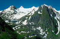 Punta dei Camosci, Blinnenhorn, Fülhorn |
Main valleys and accesses
from Switzerland (W side) : the Rhon valley
from Switzerland (N side) : val Bedretto
from Italy (E side) : valle del Toce (Formazza)
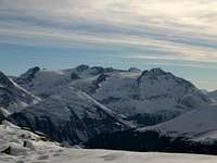
Basodino and Ticino
from P.so S.Giacomo, toward East, a secondary, but important, ridge that divides Italy (S) from Switzerland (N) and is surrounded, first on its N side, then on its SE side by the Ticino river :the Basodino and Ticino group with some remarkable summits
and many more ..
 Basodino from W | 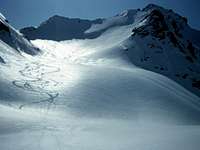 Cristallina fron NW | 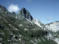 Piz Prevat |
Main valleys and accesses
from Italy (W side)
from Switzerland (S side)
from Switzerland (N side)
Rotondo
North of Nufenen pass the main ridge makes the San Gottardo group aka Rotondo group hosting some very interesting mountainsthe group ends at the S.Gottard pass.
from Poncione di Pesciora, toward N, the ridge, passing through the summits of Leckihorn (3065m) and the Mutterhorn (3067m), goes down to the Furka Pass where the Uri alps start
 Pizzo Rotondo |  Pizzo Rotondo and Poncione di Pesciora from Airolo |
Main valleys and accesses
Blas
East of S.Gottardo and till the Lucomagno Pass we have the northern border of Ticino river and, in background, toward north a small ridge of little importance delimited by the valley descending from Oberalp pass toward west (Andermatt) and East (Disentis), on this ridge some minor but fine summits ... the Pizzo Centrale (Rotstock (3001m), the Badus (2928m). the Piz Blas (3018m) and the Piz Gannaretsch (3039m) - this range is also known as Blas groupMain valleys and accesses
from S - val Leventina (Ticino river)
from E - valle del Lucomagno
from N - the road of Oberalppass
from W - the road of Gotthardpass
Medel group
East of Passo di Lucomagno the ridge rises with thecoming down again to the Passo di Greina.
 the Medel Group from North |  Piz Vallatscha |  il Sosto |
Main valleys and accesses
from W - the road of Lucomagno pass
from S
from E
from N - Surselva
Adula - Rheinwaldhorn
Now the main ridge goes toward S creating the Adula group that starts with thethen becomes the massif of
Adula (Rheinwaldhorn) (3402m)
from this summit a ridge toward NE host, in sequence, the
and goes on with the ridge that is the northern border of Rhein river, till the
 Adula (and Grauhorn), seen from the summit of Pizzo Cassimoi |  the ridge from Lorenzhorn to Beverin seen from Splugenpass |  pizzas d'Anarosa |
... more, from the Adula to SE another important ridge, dividing the Val Calanca (W) from the val S.Bernardino (E) host some fine mountains :
then the ridge goes down toward Bellinzona with a sequence on minor summit, some very fine for Ski-mountaneering.
Main valleys and accesses
from W - val Blènio
from S - val Calanca
from E - San Bernardino pass road
from N
Tambò group
The S.Bernardino Pass (2065m) is the western border of theTambò group
that is the western border of the Vallespluga where the Western Alps end.
main summits of this range are :
on its western (between the Val S.Bernardino and the Val Curciusa)
on the main ridge
this range ends at the Forcola Pass (2675m) wherefrom, to the South, starts the not famous range named Muncech (Forcola-Marmontana group)
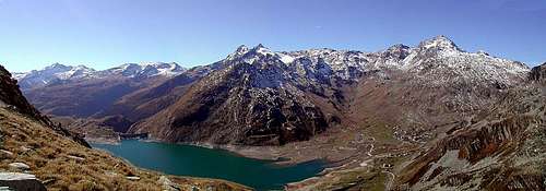
Tambò Group from the slopes of Pizzo Spadolazzo
Main valleys and accesses
from Switzerland ( W)
from Switzerland (N)
from E
see the page of Vallespluga for more detailed info
When To Climb
depending on summits and rangesmany good areas for ski-mountaneering